|
9-1-1.
General
Civil aeronautical charts
for the U.S. and its territories, and possessions are
produced by the National Aeronautical Charting Office (NACO),
which is part of FAA's Office of Aviation Systems
Standards (AVN).
9-1-2.
Obtaining Aeronautical Charts
a.
Most charts and publications described
in this Chapter can be obtained by subscription or
one-time sales from:
NACO Distribution
Division, AVN-530
Federal Aviation Administration
Riverdale, MD 20737-1199
Telephone: 1-800-638-8972 (Toll free within U.S.)
301-436-8301/6990
301-436-6829 (FAX)
b.
Public sales of charts and publications
are also available through a network of FAA chart
agents primarily located at or near major civil
airports. A listing of products and agents is printed
in the free FAA catalog, Aeronautical Charts and
Related Products. (FAA Stock No. ACATSET). A free
quarterly bulletin, Dates of Latest Editions, VFR
Aeronautical Charts (FAA Stock No. 5318), is also
available from NACO.

9-1-3.
Selected Charts and Products Available
VFR Navigation Charts
IFR Navigation Charts
Planning Charts
Supplementary Charts and Publications
Digital Products
9-1-4. General
Description of each Chart Series
a. VFR Navigation
Charts.
1. Sectional
Aeronautical Charts.
Sectional Charts are designed for visual navigation
of slow to medium speed aircraft. The topographic
information consists of contour lines, shaded
relief, drainage patterns, and an extensive
selection of visual checkpoints and landmarks used
for flight under VFR. Cultural features include
cities and towns, roads, railroads, and other
distinct landmarks. The aeronautical information
includes visual and radio aids to navigation,
airports, controlled airspace, special-use airspace,
obstructions, and related data. Scale 1 inch =
6.86nm/1:500,000. 60 x 20 inches folded to 5 x 10
inches. Revised semiannually, except most Alaskan
charts are revised annually.
(See FIG 9-1-1 and FIG 9-1-11.)
2. VFR Terminal
Area Charts (TAC).
TAC's
depict the airspace designated as Class B airspace.
While similar to sectional charts, TAC's have more
detail because the scale is larger. The TAC should
be used by pilots intending to operate to or from
airfields within or near Class B or Class C
airspace. Areas with TAC coverage are indicated by a
· on the Sectional Chart indexes. Scale 1 inch =
3.43nm/1:250,000. Charts are revised semiannually,
except Puerto Rico-Virgin Islands revised annually.
(See FIG 9-1-1 and FIG 9-1-11.)
3. World
Aeronautical Chart (WAC).
WAC's cover land areas for
navigation by moderate speed aircraft operating at
high altitudes. Included are city tints, principal
roads, railroads, distinctive landmarks, drainage
patterns, and relief. Aeronautical information
includes visual and radio aids to navigation,
airports, airways, special-use airspace, and
obstructions. Because of a smaller scale, WAC's do
not show as much detail as sectional or TAC's, and;
therefore, are not recommended for exclusive use by
pilots of low speed, low altitude aircraft. Scale 1
inch = 13.7nm/1:1,000,000. 60 x 20 inches folded to
5 x 10 inches. WAC's are revised annually, except
for a few in Alaska and the Caribbean, which are
revised biennially. (See FIG 9-1-12 and FIG 9-1-13.)
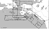
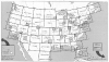
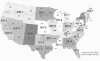
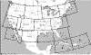
FIG 9-1-1
Sectional and VFR
Terminal Area Charts for the Conterminous U.S.,
Hawaii, Puerto Rico, and Virgin Islands
4. U.S. Gulf Coast
VFR Aeronautical Chart.
The Gulf Coast Chart is designed primarily for
helicopter operation in the Gulf of Mexico area.
Information depicted includes offshore mineral
leasing areas and blocks, oil drilling platforms,
and high density helicopter activity areas. Scale 1
inch = 13.7nm/1:1,000,000. 55 x 27 inches folded to
5 x 10 inches. Revised annually.
5. Grand Canyon
VFR Aeronautical Chart.
Covers the Grand Canyon National Park area and is
designed to promote aviation safety, flight free
zones, and facilitate VFR navigation in this popular
area. The chart contains aeronautical information
for general aviation VFR pilots on one side and
commercial VFR air tour operators on the other side.
6. Helicopter
Route Charts.
A
three-color chart series which shows current
aeronautical information useful to helicopter pilots
navigating in areas with high concentrations of
helicopter activity. Information depicted includes
helicopter routes, four classes of heliports with
associated frequency and lighting capabilities,
NAVAID's, and obstructions. In addition, pictorial
symbols, roads, and easily identified geographical
features are portrayed. Helicopter charts have a
longer life span than other chart products and may
be current for several years. All new editions of
these charts are printed on a durable plastic
material. Helicopter Route Charts are updated as
requested by the FAA. Scale 1 inch =
1.71nm/1:125,000. 34 x 30 inches folded to 5 x 10
inches.
b. IFR Navigation
Charts.
1. IFR Enroute Low
Altitude Charts (Conterminous U.S. and Alaska).
Enroute low altitude
charts provide aeronautical information for
navigation under IFR conditions below 18,000 feet
MSL. This four-color chart series includes airways;
limits of controlled airspace; VHF NAVAID's with
frequency, identification, channel, geographic
coordinates; airports with terminal air/ground
communications; minimum en route and obstruction
clearance altitudes; airway distances; reporting
points; special use airspace; and military training
routes. Scales vary from 1 inch = 5nm to 1 inch =
20nm. 50 x 20 inches folded to 5 x 10 inches. Charts
revised every 56 days. Area charts show
congested terminal areas at a large scale. They are
included with subscriptions to any conterminous U.S.
Set Low (Full set, East or West sets). (See FIG
9-1-2 and FIG 9-1-4.)
|
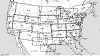
FIG 9-1-2
Enroute Low Altitude
Instrument Charts for
the Conterminous U.S. (Includes Area Charts)
|
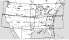
FIG 9-1-3
Enroute High
Altitude Charts for the Conterminous U.S.
|
2. IFR Enroute
High Altitude Charts (Conterminous U.S. and Alaska).
Enroute high altitude
charts are designed for navigation at or above
18,000 feet MSL. This four-color chart series
includes the jet route structure; VHF NAVAID's with
frequency, identification, channel, geographic
coordinates; selected airports; reporting points.
Scales vary from 1 inch = 45nm to 1 inch = 18nm. 55
x 20 inches folded to 5 x 10 inches. Revised every
56 days. (See FIG 9-1-3 and FIG 9-1-5.)
3. U.S. Terminal
Procedures Publication (TPP).
TPP's are published in 20 loose-leaf
or perfect bound volumes covering the conterminous
U.S., Puerto Rico and the Virgin Islands. A Change
Notice is published at the midpoint between
revisions in bound volume format. (See FIG 9-1-9.)
The TPP's include:
(a) Instrument
Approach Procedure (IAP) Charts.
IAP charts portray the
aeronautical data that is required to execute
instrument approaches to airports. Each chart
depicts the IAP, all related navigation data,
communications information, and an airport sketch.
Each procedure is designated for use with a
specific electronic navigational aid, such as ILS,
VOR, NDB, RNAV, etc.
(b) Instrument
Departure Procedure (DP) Charts.
DP charts are designed to expedite
clearance delivery and to facilitate transition
between takeoff and en route operations. They
furnish pilots' departure routing clearance
information in graphic and textual form.
(c) Standard
Terminal Arrival (STAR) Charts.
STAR charts are designed to
expedite ATC arrival procedures and to facilitate
transition between en route and instrument
approach operations. They depict preplanned IFR
ATC arrival procedures in graphic and textual
form. Each STAR procedure is presented as a
separate chart and may serve either a single
airport or more than one airport in a given
geographic area.
(d) Airport
Diagrams. Full page
airport diagrams are designed to assist in the
movement of ground traffic at locations with
complex runway/taxiway configurations and provide
information for updating geodetic position
navigational systems aboard aircraft.
4. Alaska Terminal
Procedures Publication.
This publication contains all terminal flight
procedures for civil and military aviation in
Alaska. Included are IAP charts, DP charts, STAR
charts, airport diagrams, radar minimums, and
supplementary support data such as IFR alternate
minimums, take-off minimums, rate of descent tables,
rate of climb tables and inoperative components
tables. Volume is 5-3/8 x 8-1/4 inch top bound.
Publication revised every 56 days with provisions
for a Terminal Change Notice, as required.
c. Planning Charts.
1. U.S. IFR/VFR
Low Altitude Planning Chart.
This chart is designed for prefight
and en route flight planning for IFR/VFR flights.
Depiction includes low altitude airways and mileage,
NAVAID's, airports, special use airspace, cities,
times zones, major drainage, a directory of airports
with their airspace classification, and a mileage
table showing great circle distances between major
airports. Scale 1 inch = 47nm/1:3,400,000. Chart
revised annually, and is available either folded or
unfolded for wall mounting. (See FIG 9-1-6.)
2. Gulf of Mexico
and Caribbean Planning Chart.
This is a VFR planning chart on the
reverse side of the Puerto Rico - Virgin Islands
VFR Terminal Area Chart. Information shown
includes mileage between airports of entry, a
selection of special use airspace and a directory of
airports with their available services. Scale 1 inch
= 85nm/1:6,192,178. 60 x 20 inches folded to 5 x 10
inches. Chart revised annually. (See FIG 9-1-6.)
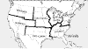
FIG 9-1-6
Planning Charts
3. Charted VFR
Flyway Planning Charts.
This chart is printed on
the reverse side of selected TAC charts. The
coverage is the same as the associated TAC. Flyway
planning charts depict flight paths and altitudes
recommended for use to bypass high traffic areas.
Ground references are provided as a guide for visual
orientation. Flyway planning charts are designed for
use in conjunction with TAC's and sectional charts
and are not to be used for navigation. Chart scale 1
inch = 3.43nm/1:250,000.
d. Supplementary
Charts and Publications.
1.
Airport/Facility Directory (A/FD).
This 7-volume booklet series contains
data on airports, seaplane bases, heliports,
NAVAID's, communications data, weather data sources,
airspace, special notices, and operational
procedures. Coverage includes the conterminous U.S.,
Puerto Rico, and the Virgin Islands. The A/FD shows
data that cannot be readily depicted in graphic
form; e.g. airport hours of operations, types of
fuel available, runway widths, lighting codes, etc.
The A/FD also provides a means for pilots to update
visual charts between edition dates (A/FD is
published every 56 days while sectional and Terminal
Area Charts are generally revised every six months).
Volumes are side-bound 5-3/8 x 8-1/4 inches. (See
FIG 9-1-10.)
2. Supplement
Alaska. This is a
civil/military flight information publication issued
by FAA every 56 days. It is a single volume booklet
designed for use with appropriate IFR or VFR charts.
The Supplement Alaska contains an A/FD, airport
sketches, communications data, weather data sources,
airspace, listing of navigational facilities, and
special notices and procedures. Volume is side-bound
5-3/8 x 8-1/4 inches.
3. Chart
Supplement Pacific.
This
supplement is designed for use with appropriate VFR
or IFR enroute charts. Included in this one-volume
booklet are the A/FD, communications data, weather
data sources, airspace, navigational facilities,
special notices, and Pacific area procedures. IAP
charts, DP charts, STAR charts, airport diagrams,
radar minimums, and supporting data for the Hawaiian
and Pacific Islands are included. The manual is
published every 56 days. Volume is side-bound 5-3/8
x 8-1/4 inches.
4. North Pacific
Route Charts.
These charts
are designed for FAA controllers to monitor
transoceanic flights. They show established
intercontinental air routes, including reporting
points with geographic positions. Composite Chart:
Scale 1 inch = 164nm/1:12,000,000. 48 x 41-1/2
inches. Area Charts: Scale 1 inch =
95.9nm/1:7,000,000. 52 x 40-1/2 inches. All charts
shipped unfolded. Charts revised every 56 days. (See
FIG 9-1-8.)
5. North Atlantic
Route Chart.
Designed for
FAA controllers to monitor transatlantic flights,
this 5-color chart shows oceanic control areas,
coastal navigation aids, oceanic reporting points,
and NAVAID geographic coordinates. Full Size Chart:
Scale 1 inch = 113.1nm/1:8,250,000. Chart is shipped
flat only. Half Size Chart: Scale 1 inch =
150.8nm/1:11,000,000. Chart is 29-3/4 x 20-1/2
inches, shipped folded to 5 x 10 inches only. Chart
revised every 56 weeks. (See FIG 9-1-7.)
6. Airport
Obstruction Charts (OC).
The OC is a 1:12,000 scale graphic depicting 14 CFR
Part 77, Objects Affecting Navigable Airspace,
surfaces, a representation of objects that
penetrate these surfaces, aircraft movement and
apron areas, navigational aids, prominent airport
buildings, and a selection of roads and other
planimetric detail in the airport vicinity. Also
included are tabulations of runway and other
operational data.
7. FAA
Aeronautical Chart User's Guide.
A booklet designed to be used as a
teaching aid and reference document. It describes
the substantial amount of information provided on
FAA's aeronautical charts and publications. It
includes explanations and illustrations of chart
terms and symbols organized by chart type.
e. Digital Products.
1. The NAVAID
Digital Data File.
This
file contains a current listing of NAVAID's that is
compatible with the National Airspace System.
Updated every 56 days, the file contains all
NAVAID's including ILS and its components, in the
U.S., Puerto Rico, and the Virgin Islands plus
bordering facilities in Canada, Mexico, and the
Atlantic and Pacific areas. The file is available by
subscription only, on 3.5-inch, 1.4 megabyte
diskette.
2. The Digital
Obstacle File.
This file
describes all obstacles of interest to aviation
users in the U.S., with limited coverage of the
Pacific, Caribbean, Canada, and Mexico. The
obstacles are assigned unique numerical identifiers,
accuracy codes, and listed in order of ascending
latitude within each state or area. The file is
updated every 56 days. File is available on
3.5-inch, 1.4 megabyte diskettes.
3. The Digital
Aeronautical Chart Supplement (DACS).
The DACS is a subset of the data
provided to FAA controllers every 56 days. It
reflects digitally what is shown on the enroute high
and low charts. The DACS is designed to be used with
aeronautical charts for flight planning purposes
only. It should not be used as a substitute for a
chart. The DACS is available on two 3.5-inch
diskettes, compressed format. The supplement is
divided into nine individual sections.
Section 1: High
altitude airways, conterminous U.S.
Section 2: Low altitude airways, conterminous U.S.
Section 3: Selected instrument approach procedure
NAVAID and fix data
Section 4: Military training routes
Section 5: Alaska, Hawaii, Puerto Rico, Bahamas
and selected oceanic routes
Section 6: STAR's - Standard Terminal Arrivals
Section 7: DP's - Instrument Departure Procedures
Section 8: Preferred IFR routes (low and high
altitude)
Section 9: Air route and airport surveillance radar
facilities
|
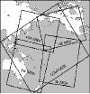
FIG 9-1-9
U.S. Terminal
Publication Volumes
|
FIG 9-1-10
Airport/Facility
Directory Geographic Areas
|
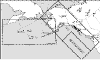
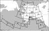
FIG 9-1-11
Sectional and VFR
Terminal Area Charts for Alaska
|
|
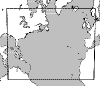
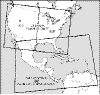
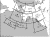
FIG 9-1-12
World Aeronautical
Charts for Alaska
|
FIG 9-1-13
World Aeronautical
Charts for the Conterminous U.S.
Mexico, and the Caribbean Areas
|
|
9-1-5. Where
and How to Get Charts of Foreign Areas
a. National Imagery
and Mapping Agency (NIMA) Products.
An FAA catalog of NIMA Public Sale
Aeronautical Charts and Publications (FAA Stock
No. DMAACATSET), is available from the NACO
Distribution Division. The catalog describes available
charts and publications primarily covering areas
outside the U.S. A free quarterly bulletin, Dates
of Latest Editions - NIMA Aeronautical Charts and
Publications (FAA Stock No. DADOLE), is
also available from NACO.
1. Flight
Information Publication (FLIP) Planning Documents.
General Planning (GP)
Area Planning
Area Planning - Special Use Airspace -
Planning Charts
2. FLIP Enroute
Charts and Chart Supplements.
Pacific, Australasia,
and Antarctica
U.S. - IFR and VFR Supplements
Flight Information Handbook
Caribbean and South America - Low Altitude
Caribbean and South America - High Altitude
Europe, North Africa, and Middle East -
Low Altitude
Europe, North Africa, and Middle East -
High Altitude
Africa
Eastern Europe and Asia
Area Arrival Charts
3. FLIP Instrument
Approach Procedures (IAP's).
Africa
Canada and North Atlantic
Caribbean and South America
Eastern Europe and Asia
Europe, North Africa, and Middle East
Pacific, Australasia, and Antarctica
VFR Arrival/Departure Routes - Europe and Korea
U.S.
4. Miscellaneous
DoD Charts and Products.
Aeronautical Chart
Updating Manual (CHUM)
DoD Weather Plotting Charts (WPC)
Tactical Pilotage Charts (TPC)
Operational Navigation Charts (ONC)
Global Navigation and Planning Charts (GNC)
Global LORAN-C Navigation Charts (GLCC)
LORAN-C Coastal Navigation Charts (LCNC)
Jet Navigation Charts (JNC) and Universal Jet
Navigation Charts (JNU)
Jet Navigation Charts (JNCA)
Aerospace Planning Charts (ASC)
Oceanic Planning Charts (OPC)
Joint Operations Graphics - Air (JOG-A)
Standard Index Charts (SIC)
Universal Plotting Sheet (VP-OS)
Sight Reduction Tables for Air Navigation (PUB249)
Plotting Sheets (VP-30)
Dial-Up Electronic CHUM
b. Canadian Charts.
Information on available
Canadian charts and publications may be obtained from
designated FAA chart agents or by contacting the:
Canada Map Office
Department of Natural Resources
130 Bentley Ave
Nepean, Ontario
K1A 0E9, Canada
Telephone: (613) 952-7000 or
1-800-465-6277
Fax: (613) 957-8861 or
1-800-661-6277
c. Mexican Charts.
Information on available
Mexican charts and publications may be obtained by
contacting:
Dirección de Navigacion
Aereo
Blvd. Puerto Aereo 485
Zona Federal Del Aeropuerto Int'l
15620 Mexico D.F.
Mexico
d. International
Civil Aviation Organization (ICAO).
A free ICAO Publications and
Audio-Visual Training Aids Catalogue is available
from:
International Civil
Aviation Organization
ATTN: Document Sales Unit
999 University Street
Montreal, Quebec
H3C 5H7, Canada
Telephone: (514) 954-8022
Fax: (514) 954-6769
E-mail: sales_unit@icao.org
Internet:
http://www.icao.org/cgi/goto.pl?icao/en/sales.htm
Sitatex: YULCAYA
Telex: 05-24513

|