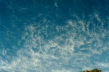
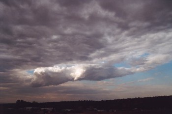
Higher level clouds
Cirrus and
cirrostratus
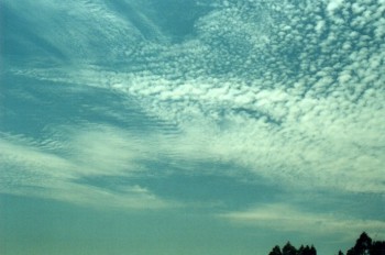
Cirrocumulus
middle
clouds
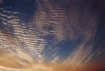
Altocumulus
Altocumulus Castellanus
Altostratus
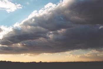
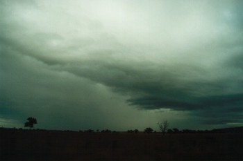
Nimbostratus
low clouds
Stratus
Stratocumulus
Nimbostratus
clouds of vertical development
Cumulus (Cu)
Towering Cumulus (TCu)
Cumulonimbus (Cb)
cloud formation
precipitation
thunderstorms
orographic_lift
convection
frontal lift
convergence
It is
essential that the pilot has a good knowledge of meteorology and that he/she
understands what weather conditions are existing. Cloud formations will give a
clear indication of this.
classifications of clouds
Clouds can occur at any level of the
atmosphere wherever there is sufficient moisture to allow condensation to take
place. The layer of the atmosphere where almost all cloud exists is the
troposphere, although the tops of some severe thunderstorms occasionally
pierce the tropopause.
Because of the large range in temperatures and
air movement in the troposphere, clouds vary in structure and composition (a
combination of ice crystal and water). Consequently, clouds are classified into
three main groups: lower, middle and high level clouds.
Higher level clouds
Higher level clouds represent
the cloud in the highest levels of the troposphere. They mostly appear brilliant
white because of the ice crystals at that level. They tend to develop at or just
above the top part of the troposphere. Higher level clouds can vary in shape,
thickness and cover.
Sunlight can be observed passing
through the higher level clouds most of the time. The amount of light that
penetrates depends on the density and thickness of the layers. The thickness of
such clouds are therefore relatively thin.
In most cases, the direction of
movement of the higher level clouds do not necessarily represent the wind
direction at the ground level. In fact, the wind at upper and ground levels
often differ.
There are three main types of
higher level clouds: cirrus, cirrostratus and cirrocumulus.
The bases of
high clouds range from 16,500 feet to 45,000 feet and average about 25,000
feet in the temperate regions.
Cirrus and cirrostratus
(Cl)(Cs)
Since the characteristics of
cirrus and cirrostratus are similar, they can be discussed together including
any differences.
Cirrus clouds are higher level
clouds that develop in filaments or patches. They are virtually brilliant white
attributed to their ice crystal composition. However, they lack in contrast
between the top and base. They occur in flat sheets with a low height to base
ratio and are usually isolated with large breaks of sky. Cirrus also vary
dramatically in 'shape' or patterns they portray but these represent the
fluctuating wind flow at that level both in the horizontal and vertical
direction.
Cirrostratus represent clouds
that are more widespread than cirrus but containing some similar features. Like
cirrus, they are brilliant white and lack in contrast. Sunlight can pass through
cirrostratus but this again depends on the varying thickness of the clouds.
Both cirrus and cirrostratus
clouds vary in thickness. The sun can easily be observed through both types of
clouds although the intensity of light that is observed depends on the thickness
of their layers. In their thickest form, cirrus and cirrostratus will allow a
similar intensity of light to pass through to that of thin altostratus. They do
not only develop in one complete layer. It may be difficult to observe because
of the lack of contrast but these clouds can consist of several thin layers.
Cirrus and cirrostratus tend to
move in the direction of the wind at that level which differ to that at the
surface. The most common direction of motion of these clouds are from a westerly
direction. This varies with factors such as the latitude, weather conditions and
time of the year. Their apparent velocities are relatively slow as compared to
lower clouds.
Both cirrus and cirrostratus can
occur in conjunction with any of the other cloud types. Obviously, all the lower
and middle level clouds will obscure the view of the higher level clouds, appear
to move faster and appear less defined. They can only be observed above other
clouds when breaks in the clouds occur. Any type of higher level clouds can
develop simultaneously.
Cirrus clouds tend to develop on
days with fine weather and lighter winds at the surface. cirrostratus can
develop on days with light winds but normally increasing in strength. Although
both cirrus and cirrostratus tend to develop in fine weather conditions, they
also acts as a sign of approaching changes in the weather conditions. Such
changes could include any of the various types of cold front situations,
thunderstorms or developing and advancing troughs of low pressure, normally with
preceding cloud masses.
Except in the latter case,
cirrus and cirrostratus will typically precede any other types of clouds as part
of a cloud band. In fact cirrus normally precedes cirrostratus. Nevertheless,
the higher level clouds will persist until the actual change in the weather
occurs. The higher clouds can develop from a few hours up to a few days before
an actual change in the weather conditions occurs. They may develop during one
afternoon and dissipate but redevelop the next day and so on until the actual
change occurs. If the amount of moisture in the lower layers of the atmosphere
increases, other lower clouds may also develop changing the appearance of the
cirrus or the cirrostratus clouds as well as partially or totally hiding them
from view. The same situation occurs in the case where cirrus develop ahead of
thunderstorms. Cirrus normally precede cirrostratus which are then followed by
the anvil of the approaching thunderstorm. In fact, cirrus and cirrostratus in
this case are the remnants downwind of the weakening anvil.
Both cirrus and cirrostratus can
develop and persist after a change has passed through a certain location. In
this situation, cloud will decrease within a few hours up to a few days
following the change. If it persists for longer periods, a jet stream cloud mass
may be involved.
Another situation where cirrus
and cirrostratus can be observed is when lower cloud breaks or clears during
days with showers or rain. This case is far less common but can indicate a few
situations. The higher clouds may be the remnants of the cloud mass that
produced the actual wet weather. They can also be developing ahead of other
cloud masses associated with another system, leading to the situation already
discussed above. It all depends on the weather situation at that time but the
observation of the movement of the higher level clouds can be critical in
determining what weather may follow.
Cirrus generally does not
produce precipitation except when it results from dissipating thunderstorms.
Precipitation from such cirrus usually consists of larger droplets and the cloud
normally dissipates and vanishes completely. cirrostratus does not produce
precipitation.
Cirrus and cirrostratus can
develop and persist at any time of the day despite the perception that it tends
to occur during the day. This perception arises because it is much easier to
observe cirrus during the day as compared to night time. The background darkness
and the fact that the stars can easily be observed through cirrus and
cirrostratus as thin layers allows them to camouflage from the view of the
observer.

Cirrocumulus is a higher level cloud that is brilliant white but with a spotty
appearance created by the many small turrets. The turrets indicate vertical
turbulence within the cloud. Despite this spotty appearance, cirrocumulus
contains many features associated with cirrostratus discussed above. It moves in
directions similar to that of the other higher clouds.
This cloud can develop in
conjunction with any other clouds as well as with cirrostratus clouds. In
Sydney, cirrocumulus is not as common as the other high clouds and mainly
develops during the winter times with west to south westerly air streams. The
development of cirrocumulus sometimes occurs in conditions similar to those
associated with the development lenticular altocumulus. cirrocumulus clouds do
not produce precipitation and are normally associated with fine weather.
middle
clouds
Middle
level clouds are those clouds that develop in the middle layers of the
atmosphere. These clouds are brighter and less fragmented in appearance due to
their distance from the ground and the higher composition of ice crystals.
Middle level clouds vary in thickness from relatively flat sheets of cloud to
a more cumuliform appearance. In fact, the sun (and moon) can be observed
through some thin middle level clouds.
Middle level clouds tend to have apparent
speeds slower than the lower level clouds. (Recall the larger radius and
associated arc length that the higher level clouds must undertake). They move
in the direction of the wind at that level which does not necessarily be the
same of that at the surface.
There are 3 basic types of middle level clouds:
altocumulus, altostratus and nimbostratus.
The bases of middle clouds range from 6500 feet to 23,000 feet.
Altocumulus
(Ac)
As the name suggests,
altocumulus refers to the middle level cloud that exhibit to some extent the
features normally associated with cumulus. This includes cumuliform tops and
bases that are usually relatively darker than the tops. This cloud type can be
widespread or patchy depending on the conditions. It can vary in appearance from
broken to smooth, and vary in thickness.
In its broken form, altocumulus
can be confused with stratocumulus. To distinguish between them requires
examining how defined the cloud appears, whether there other forms of middle
level or upper level clouds present above the layer and the difference in
brightness. Like stratocumulus, the breaks become more visible at a steeper
angle of elevation.
If conditions are unstable in
the middle level of the atmosphere, the air will tend to rise in currents
allowing areas of cumuliform turrets to develop. In fact, altocumulus can
develop from dissipating thunderstorms during the morning and then redevelop
during the day if the air remains unstable. Altocumulus clouds therefore in this
form indicate unstable or unsettled conditions.
Altocumulus can vary in its
apparent movement (speed) depending on the wind and direction at that level.
However, since altocumulus (like most other cloud types) represents an ever
changing system, an observer must be careful in determining cloud motion. On
some days, altocumulus continuously develop as it moves in the direction of the
wind. Upstream, more altocumulus may develop giving the impression that the
cloud is progressing slower than its actual speed. This process can occasionally
create an illusion in terms of direction. Considering an example of altocumulus
observed moving to the south east, because of development on the north and
north-eastern side of the cloud band, the apparent direction may be more to the
east.
Altocumulus can develop in more
than one layer and also in conjunction with other cloud types. The lower layer
will obscure part or all of the higher altocumulus cloud layer. This situation
also applies to higher level clouds. Higher level clouds will be obscured by the
altocumulus. Lower level clouds, however, will obscure part or all of the
altocumulus cloud layer. In fact, it may be impossible to observe altocumulus
above a full stratocumulus, stratus or lower level nimbostratus cover. If a
break occurs, altocumulus can only be distinguished by its different (slower)
speed and direction of movement.
Altocumulus also develop within
the structure of cumulonimbus (thunderstorm producing) clouds. The appearance of
altocumulus within thunderstorms vary depending on the structure, severity and
the amount of moisture drawn into the thunderstorm. The altocumulus usually
develops after the anvil (consisting of cirrostratus and altostratus) develops
and becomes darker as the precipitation cascade approaches. However, on days
where thunderstorms develop with widespread altocumulus conditions, the
altocumulus obscures the thunderstorms and its development observed only through
breaks in the cloud.
If altocumulus develops into
thicker layers, precipitation can develop. The intensity of rainfall most often
expected from altocumulus is light to moderate rainfall. If large cumulus
develop amongst the rain bearing altocumulus, then heavier rainfall will
develop. On days when precipitation from altocumulus becomes widespread and
continuous, the cloud forms a smooth lighter-grey shaded sheet and becomes known
as nimbostratus (at the middle layers).
Precipitation within altocumulus
can develop rapidly at the rear even though the cloud may be moving fairly
rapidly. This will obviously influence the duration of rainfall as well as the
normally large cloud base. This situation often occurs before a cold front with
unstable conditions. Thunderstorms can develop amongst the altocumulus band or
they may develop after the cloud band clears well ahead of the actual change.
As discussed in the case of
other clouds, lower clouds may be present below the altocumulus layer but not
producing the rain. The observer again must consider which cloud is producing
the rain to determine in which direction it is moving.
Another form of altocumulus is
the lenticular type where the altocumulus appears in the form of a lens. They
appear very smooth and flat, often displaying two or more layers. This occurs
due to a wave effect in the air flow. This wave effect normally develops as a
result of a mountain range on windy days. The wave effect forces air to rise
above the condensation level and hence allows cloud to form. Due to the rise and
fall effect (peaks and troughs), the cloud may only exist in areas of peaks and
therefore appear patchy. The most striking feature of this cloud is that it
tends to remain relatively stationary compared with the associated wind at that
level. What is actually happening is that as the air begins to rise above the
level of condensation, cloud forms. When the air falls below this level,
dissipation occurs and the cloud disintegrates back to clear air. So long as the
peak of the air wave remains stationary as compared to the ground, the cloud
will develop and dissipate almost in the same position whilst the wind
conditions persist.
The direction of the wind
associated with lenticular altocumulus can be determined by considering the
sharpest edge as the end of the cloud where the air is flowing in and the
opposite end where the air is flowing out. Sometimes this will be the longest
span of cloud. The most efficient method of determining the direction of the
wind is by closely examining the direction that the patterns and ripples within
the cloud base move. The cloud will also be moving in the direction of the wind
within the cloud region.
Lenticular altocumulus is
generally not associated with precipitation. The conditions associated with the
development of this cloud involves more horizontal rather than vertical flow.
The air masses are also more stable and drier.
Lenticular altocumulus mostly
develop during the day when the atmosphere is most lively in terms of strong
winds at that level. The wind conditions at the surface are often very similar
to the direction of wind at the cloud level. In the case of Sydney, lenticular
altocumulus tend to develop during the morning period and clear off the coast
during the evening. Almost all lenticular altocumulus in Sydney develop under
the influence of south westerly, westerly or north westerly air streams
associated with cold fronts.
Altocumulus can also develop in
the form of ripples. In this case, the altocumulus cloud appears broken but
lined as a result of minor wind wave ripples. In fact it develops in conditions
associated with the development of lenticular altocumulus. This type of cloud
obviously does not produce precipitation.
Altocumulus can develop from the
spreading out of the tops of cumulus. The spreading out occurs as the tops of
the cumulus grows until it reaches an inversion layer (or stronger winds that
cause divergence) situated in the middle levels of the atmosphere. Because the
cumulus updraughts are not strong enough to pierce this layer, the tops begin to
spread in the form similar to that of an anvil facing in the direction of the
wind at that level. Occasionally, this situation may further develop into
thunderstorm or thundery shower conditions.
Altocumulus
Castellanus (Acc)
Altocumulus with a turreted
appearance. Instability is a characteristic. Altocumulus castellanus may develop into cumulonimbus. (below)
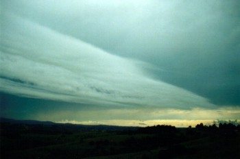
Altostratus (As)
Altostratus refers to middle
level cloud that appears as a flat, smooth dark grey sheet. These clouds are
most often observed as large sheets rather than isolated areas. However, in the
process of development, altostratus may develop in smaller filaments and rapidly
develop to larger sheets. These types of clouds in certain conditions normally
indicate an approaching cloud mass associated with a cold front, a trough system
or a jet stream.
Altostratus can develop into a
thick or thin layer. As a thin layer, the sun can be observed through the cloud.
In its thinner form, the developing altostratus can sometimes be confused with
approaching cirrostratus. In its thicker form, the sun can only occasionally be
observed through the thinner sections if not at all. Obviously, the thicker the
altostratus, the darker it becomes. When observed closely, it becomes apparent
that altostratus is not just one complete layer but a composition of several
thin layers.
Altostratus can produce
precipitation. It will normally develop and then thicken. The precipitation is
observed as relatively thick dark sections since precipitation cascades are very
difficult to observe with the same colour in the background. In this situation,
rain will develop as a light shower and gradually increase to showers, light
rain or moderate rain. If the precipitation becomes persistent, the cloud then
becomes known as nimbostratus. The duration of the precipitation is influenced
by factors similar to those discussed with other types of clouds.
In certain conditions,
altostratus will develop during the afternoon period and increase to cover most
or all of the sky. By late afternoon, evening or during the night, precipitation
will develop. This situation is the most common observation that occurs in
Sydney. However, altostratus can develop at any time as well as the associated
precipitation.
As discussed above, altostratus
can develop in conjunction with other clouds such as cirrostratus, altocumulus
and stratocumulus. Obviously, the lower clouds will obscure the view of
altostratus, appear to move faster and appear less defined. Although altocumulus
is a middle level cloud, it will develop below altostratus. Sometimes,
altocumulus can be observed developing from dissipating altostratus.
cirrostratus can often be observed above altostratus when it does not cover the
sky. On days where altostratus is observed above a stratocumulus cover, it may
indicate a trough with possible rain or even thunderstorms either during the
afternoon or within the next few days.
Like altocumulus, altostratus
also forms part of thunderstorms normally within or below the lower part of the
anvil region. Of course this depends on the height of the thunderstorm anvil.
Different structures of thunderstorms display various forms of altostratus. As
the anvil of the thunderstorm passes overhead, the altostratus begins to appear
normally with a grey base but becoming increasingly dark.
Some altostratus develop in
situations similar to the development of lenticular altocumulus. Altostratus in
this form develops in large sheets and has a patchy base appearance. The cloud
seems to be moving rapidly but because of its development at the rear actually
progresses very slowly in the direction of the wind at that level. This type of
cloud does not produce any rain.
Nimbostratus can be described as
a widespread light grey or white sheet of cloud that produces persistent rain or
showers. Because of its light colours, nimbostratus lacks contrast and in fact
is quite difficult to photograph. Being sufficiently thick to produce
precipitation, the sun or moon can rarely be observed through nimbostratus.
The cloud may be more than 15,000 feet
thick. It is generally associated with warm fronts.
Because of its lack of contrast,
it is difficult to determine the apparent speed and direction of nimbostratus.
This speed can sometimes be determined by observing the movement of a break in
the cloud or observing the cloud's motion against the occasional glimpse of the
sun or the moon that is relatively motionless. Another method involves the
observation of approaching intermittent showers although patterns of
precipitation can sometimes change dramatically.
Generally, precipitation
associated with nimbostratus is long in duration. The intensity can vary from
light to heavy depending on the associated conditions. Normally, light to
moderate rain is associated with nimbostratus. However, the passage of strong
lows and cold fronts can produce moderate to heavy precipitation. In Sydney,
weather associated with flooding rains often contains thick nimbostratus layers.
As discussed in earlier cases,
nimbostratus can develop or occur with most other types of clouds. Stratus and
stratocumulus will often develop below nimbostratus in its middle level form and
obscure the view of the whole cloud base. With approaching precipitation
regions, the lower clouds may appear darker or lighter than the nimbostratus
creating some contrast. This depends on the intensity of the background
nimbostratus. The movement of the lower clouds do not necessarily have to be the
same as the nimbostratus.
Although stratocumulus clouds
can develop below nimbostratus, they can also thicken to develop into a
nimbostratus layer with precipitation. This refers to nimbostratus in its lower
levels of the atmosphere. It can be difficult to distinguish this from
nimbostratus in the middle levels of the atmosphere. It often requires
observation of the initial cloud (stratocumulus or altostratus) or the cloud
that follow. Another useful method is measuring the apparent speed of the cloud
if it can be observed. Of course, the lower the cloud, the less likelihood that
lower clouds will be observed below the nimbostratus.
Nimbostratus can develop from
altostratus if it becomes sufficiently thick to produce precipitation. In fact,
increasing altostratus cloud tends to lead to nimbostratus. Generally, the
altostratus will become darker and gradually rain will develop. This sometimes
leads to a lighter appearance of the cloud base although the cloud still remains
reasonably thick.
Lower level nimbostratus can
develop below altostratus and partially or completely obscure it from view.
However, if the altostratus layer develops into nimbostratus itself, the lower
level nimbostratus will most probably become difficult to see especially if
precipitation begins to fall.
The weather conditions that
produce middle level (and sometimes lower level) nimbostratus also lead to the
development of higher level clouds. Nimbostratus developing or occurring below
higher level clouds will obscure most or all of it from view. The higher clouds
can only be observed through breaks of the nimbostratus if and when they occur.
These breaks often occur when the cloud is decreasing in intensity and
conditions are beginning to clear.
low clouds
Lower level clouds consist of
those clouds in the lower layers of the atmosphere. Because of the relatively
low temperatures at this level of the atmosphere, lower level clouds usually
reflect lower amounts of light and therefore usually exhibit low contrast. The
clouds at this level also appear not as well defined. When observed closely,
it is easy to observe the turbulent motions and hence the ever-changing
structure.
Being closer to the ground,
lower level clouds appear to move or progress faster than other clouds. The
clouds generally move in the direction of the wind very similar to the direction
of the wind on the ground.
The most efficient method used
to recognise lower clouds is when observed in conjunction with other clouds. The
lower clouds will obscure part or all the view of the upper level clouds if they
pass in between the observer's line of sight. In other words, all the observer
can see is the lower clouds as well as parts of the higher level clouds through
breaks of the lower clouds. What is observed will vary due to the different
directions and relative wind speeds associated with the different layers of
clouds.
There are 3 main types of lower
level clouds: cumulus, stratocumulus and stratus.
The bases of low clouds range
from surface height to about 6500 feet.
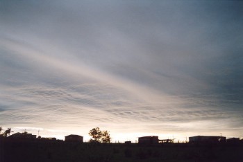
Stratus (St)
Stratus is defined as low cloud
that appears fragmented and thin. It can also occur in the form of a layer or
sheet. The sun, moon and generally the sky can usually be observed through
stratus clouds, especially at a steep angle of elevation. Stratus lacks the
vertical growth of cumulus and stratocumulus, and therefore lacks the
contrast. This is more evident when observed as one layer as compared to
patchy stratus. Being closest to the ground, stratus clouds normally move
fairly rapidly in the direction of the wind depending of course on the wind
speed.
Like stratocumulus, stratus
develops under several conditions or weather situations. Stratus mostly
develop under the influence of wind streams where moisture condenses in the
lower layers of the atmosphere. Wind changes during the summer months often
lead to the development of stratus as the wind evaporates moisture from the
ocean and condensing as turbulence mixes the surface air with the cooler air
above. In these conditions, stratus develop in patches and gradually may
become widespread forming into stratocumulus.
On days with nimbostratus and rain, stratus cloud develop simply due to the
amount of moisture in the air. With light winds, stratus are normally observed
in sheets. In stronger wind conditions, stratus develops in patches, similar
in appearance to stratocumulus. Both the direction and appearance of stratus
can change rapidly with changing weather conditions. It can clear and
redevelop several times during certain conditions usually appearing when rain
approaches, and clearing as the rain clears. Being the lowest cloud layer, it
obscures at least partially the view of stratocumulus or other types of clouds
above.
Stratus, like stratocumulus, can develop in weather conditions associated with
thunderstorms and thunderstorm development. In this case, stratus is observed
moving rapidly towards the storms and thickening in the region of the
updraughts, especially those of severe thunderstorms. The stratus is only the
visible condensed water vapour feeding into the thunderstorm. One good example
of a thunderstorm illustrating this behaviour is the violent hailstorm that
occurred on the 18th of March, 1990 in Sydney (This storm is not illustrated
here). Earlier in the day, stratus had developed with a south to
south-easterly change and was moving rapidly with the air stream. As the
thunderstorms developed and approached, the stratus thickened to form
stratocumulus. As the storm (which was a supercell) with the updraught region
moved almost overhead, the stratocumulus cleared rapidly. The major rain band
then moved through with strong winds, heavy rain and medium to large hail in
some areas.
Stratus can develop in the various types of weather conditions associated with
stratocumulus discussed above. However, the characteristics of stratus do not
vary as much as stratocumulus and therefore they are easily distinguishable.
Therefore, there is no real need to discuss further the weather conditions
associated with stratus clouds.
Stratocumulus (Sc)
Stratocumulus are low clouds
that generally move faster than cumulus and are not as well defined in
appearance (recall the techniques of observing clouds). They tend to spread more
horizontally rather than vertically. Like cumulus, the bases of stratocumulus
are normally darker than the tops. However, they can vary in terms of
characteristics.
Depending on the weather
conditions, stratocumulus can appear like cumulus since stratocumulus can
develop from cumulus. They may also appear as large flat areas of low, grey
cloud. Sometimes stratocumulus appear in the form of rolling patches of cloud
aligned parallel to each other. Stratocumulus can also appear in the form of
broken clouds or globules. The sun, moon and generally the sky can be observed
through the breaks in broken stratocumulus clouds. Of course, this depends on
how large the breaks are, how high the clouds rise and the angle of elevation of
the breaks with respect to the observer. This generally applies to all clouds
but is more notable with clouds in broken form.
Stratocumulus mostly develop in
wind streams moving in the direction of the wind similar to the direction of the
wind at the surface. The friction created by the earth causes turbulence in the
form of eddies. With sufficient moisture, condensation will occur in the lower
layers of the atmosphere visible as clouds. The amount of stratocumulus covering
the sky depends on the amount of moisture concentrated at that level of the
atmosphere. The speed that the cloud moves varies according to the wind speed at
that level.

Stratocumulus cloud also can
develop in the form of lenticularis. The only method that can be used to
distinguish between these clouds is that stratocumulus will not appear as well
defined, will tend to move more quickly. Sometimes they develop below cumulus or
cumulonimbus which means that it must be low cloud.
Nimbostratus (Ns)
A low layer of uniform, dark
grey cloud. When it gives precipitation, it is in the form of continuous rain
or snow. The cloud may be more than 15,000 feet thick. It is generally
associated with warm fronts.
Little turbulence occurs in
stratus. The low cloud bases and poor visibility make VFR operations
difficult to impossible.
clouds of vertical development
The bases of this type of cloud
may form as low as 1500 feet. They are composed of water droplets when the
temperature is above freezing and of ice crystals and supercooled water
droplets when the temperature is below freezing.
Cumulus (Cu)
Cumulus are cauliflower-shaped
low level clouds with dark bases and bright tops. When observing cumulus, you
are actually observing the condensation process of rising thermals or air
bubbles at a certain level in the atmosphere known as the condensation level.
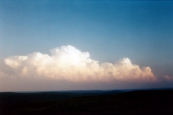
The air rising above this level
condenses and cloud is observed. Since the height of this level is fairly
constant at any particular time, then the bases of cumulus are usually flat.
The appearance of cumulus like
other clouds can be illusive. If stratus formed at the same level as cumulus,
the cumulus will appear different observed from different perspectives with
respect to the sun's position. (If light from the sun must reflect to get to the
observer, then the cloud will tend to appear brighter and display more contrast
than cloud reflecting very little direct sunlight. In fact, the latter case
indicates that the shadow area of the cloud is facing the observer). A similar
situation may occur when observing cumulus below a much darker background such
as a thunderstorm. The cumulus clouds appear as a uniform white or at least much
lighter with little or no contrast. The same cumulus clouds observed away from
this cloud band will appear darker, with more contrast.
With practice, an observer can
easily determine the size of cumulus clouds (or any clouds in general) by
considering the following factors; their apparent distances, coverage of the sky
(density), their angle of elevation (how much of their base can be observed),
how much overlapping occurs, and their base to height ratio. Cumulus often
occurs in conjunction with other clouds and may vary in appearance. If cumulus
is observed below other clouds, the shadow effect of other clouds can decrease
contrast of the cumulus.
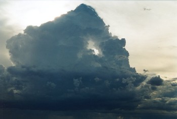
Towering Cumulus
(TCu)
Cumulus clouds that build up
into high towering masses. They are likely to develop into cumulonimbus.
Rough air will be encountered underneath this cloud. Heavy icing may occur in
this cloud type. (below)

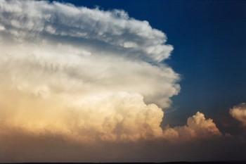
Cumulonimbus (Cb)
Heavy masses of cumulus
clouds that extend well above the freezing level. The summits often
spread out to form an anvil shaped top that is characteristic of thunderstorm.
(below)
cloud formation
Generally upward motion of
moist air is a prerequisite for cloud formation, downward motion dissipates
it. Ascending air expands, cools adiabatically and, if sufficiently moist,
some of the water vapour condenses to form cloud droplets. Fog is
likely when moist air is cooled, not by expansion but by contact with a colder
surface.
The diameter of the condensation
nuclei is typically 0.02 microns but a relatively small number may have a
diameter up to 10 microns. Maritime air contains about one billion nuclei per
cubic metre, polluted city air contains many more. The diameter of a cloud
droplet is typically 10 to 25 microns and the spacing between them is about 50
times diameter, perhaps one mm, with maybe 100 million droplets per cubic metre
of cloud. The mass of liquid in an average density cloud approximates 0.5 gram
per cubic metre.
Above the freezing level in the
cloud some of the droplets will freeze if disturbed by contact with suitable
freezing nuclei, or an aircraft. Freezing nuclei are mainly natural clay mineral
particles, bacteria and volcanic dust, perhaps 0.1 microns in diameter. There
are rarely more than one million freezing particles per cubic metre thus there
are only sufficient to act as a freezing catalyst for a small fraction of the
cloud droplets. Most freezing occurs at temperatures between –10 °C and –15 °C.
The balance of the droplets
above freezing level remains in a supercooled liquid state, possibly down
to temperatures colder than –20 °C, but eventually, at some temperature warmer
than –40 °C, all droplets will freeze by self-nucleation into ice
crystals, forming the high level cirrus clouds. In some cases fractured or
splintered ice crystals will act as freezing nuclei. The ice crystals are
usually shaped as columnar hexagons or flat plate hexagons, refer 3.5.2 below
and 12.2.2.
Condensation of atmospheric
moisture occurs when:
 the volume of air remains
constant but temperature is reduced to dewpoint, e.g. contact cooling, mixing
of different layers
the volume of air remains
constant but temperature is reduced to dewpoint, e.g. contact cooling, mixing
of different layers
the volume of an air parcel is
increased through adiabatic expansion
evaporation increases the
vapour partial pressure beyond the saturation point
a change of both temperature
and volume reduces the saturation vapour partial pressure.
precipitation
Rain [RA] and drizzle [DZ]
Cloud droplets tend to fall but
their terminal velocity is so low, about 0.01 metres/sec, that they are kept
aloft by the vertical currents associated with the cloud construction process,
but will evaporate when coming into contact with the drier air outside the
cloud. Some of the droplets are larger than others and consequently their
falling speed is greater. Larger droplets catch up with smaller and merge or
coalesce with them eventually forming raindrops. Raindrops grow with the
coalescence process reaching maximum diameters, in tropical conditions, of 4 – 7
mm before air resistance disintegrates them into smaller raindrops, which start
a self perpetuating process. It takes about one million cloud droplets to form
one raindrop.
The terminal velocity of a 4 mm
raindrop is about 9 metres/sec. Only clouds with extensive depth, 3000 feet
plus, will produce rain (rather than drizzle) but very small high clouds,
generating heads, may produce trails of snow crystals which evaporate at lower
levels – fall streaks or virga.
Drizzle
forms by coalescence in stratiform clouds with depths possibly less than 1000
feet and with only weak vertical motion, otherwise the small ( 0.2 – 0.5 mm)
drops would be unable to fall. It also requires only a short distance or a high
relative humidity between the cloud base and the surface, otherwise the drops
will evaporate before reaching the surface. Terminal velocity approximates 1 – 2
metres/sec.
Light drizzle [–DZ]: visibility greater than 1000 metres
Moderate drizzle [DZ]: 500 to 1000 metres
Heavy drizzle [+DZ]: less than 500 metres
Light rain showers: precipitation rate under 2.0 mm/hour
Moderate rain showers: 2.0 to 10 mm/hour
Heavy rain showers: more than 10 mm/hour
Light rain [–RA]:
under 0.5 mm/hour, individual drops easily seen
Moderate rain [RA]: 0.5 to 4 mm/hour, drops not easily seen
Heavy rain [+RA]: more than 4 mm/hour, rain falls in sheets
Weather radar reports precipitation into six
reflectivity levels:
light
precipitation
light to moderate rain
moderate to heavy rain
heavy rain
very heavy rain, hail possible
very heavy rain and hail, large hail possible
Scotch mist
is a mixture of thick cloud and heavy drizzle on rising ground, formed in
conditions of weak uplift of almost saturated stable air.
Snow [SN]
At cloud temperatures colder than –10 °C where
both ice and supercooled liquid water exist, the saturation vapour pressure over
water is greater than that over ice. Air that is just saturated with respect to
the supercooled water droplets will be supersaturated with respect to the ice
crystals, resulting in vapour being deposited onto the crystal. The reduction in the amount of water vapour means that the air is
no longer saturated with respect to the water droplets and, to achieve
saturation equilibrium again, the water droplets begin to evaporate. Thus ice
crystals grow by sublimation and water droplets lessen, i.e. in mixed cloud the
ice crystals grow more rapidly than the water droplets. Snow is frozen
precipitation resulting from ice crystal growth and falls in any form between
small crystals and large flakes. This is known as the Bergeron-Findeison theory
and probably accounts for most precipitation outside the tropics. Snow may fall
to the surface or, more often, melt below the freezing level and fall as rain.
Snowflakes
are built by snow crystals colliding and sticking together in clusters of
several hundred – aggregation. Most aggregation occurs at temperatures just
below freezing, the snow crystals tending to remain separate at colder
temperatures.
Hail and other ice forms
The growing snow crystals
acquire a fall velocity relative to the supercooled droplets and growth also
continues by collision and coalescence with supercooled droplets forming ice
pellets [PE], the process being termed accretion,or opaque riming
if the freezing is instantaneous incorporating trapped air, glazing if
the supercooled water freezes more slowly as a clear layer. The ice pellets in
turn grow by coalescence with other pellets and further accretion and are termed
hail [GR] when the diameter exceeds 5 mm. The size reached by hailstones
before falling out of the cloud depends on the velocity and frequency of
updraughts within the cloud. Hail is of course an hazard to aviation,
particularly when it is unexpected, for example hail falling from a Cb anvil can
appear to fall from a clear sky. Snow grains [SG] are very small,
flattened, opaque ice grains, less than 1 mm and equivalent to drizzle.
Snowflakes that, due to accretion, become opaque, rounded and brittle pellets, 2
– 5 mm diameter, are called snow pellets or graupel [GS]. Sleet
is transparent ice pellets less than 5 mm diameter that bounce on impact with
the ground. Sleet starts as snow, partially melting into rain on descent through
a warm layer, then refreezing in a cold near-surface layer. The term is
sometimes applied to a snow/rain mixture or just wet snow. Diamond dust [IC]
is minute airborne ice crystals that only occur under very cold (Antarctic)
conditions.
When
raindrops form in cloud top temperatures
warmer than –10 °C the rain falls as supercooled drops. Such freezing rain
or drizzle striking a frozen surface, or an aircraft flying in OAT at or below
zero, will rapidly freeze into glaze ice. Freezing rain is responsible for the
ice storms of North America and northern Europe, but the formative conditions
differ from the preceding.
The seeder – feeder mechanism
Any large scale air flow over mountain areas
produces, by orographic effect, ice crystals in cold cloud tops. By themselves
the falling crystals would cause only light drizzle at the ground. However as
the crystals fall through the low level mountain top clouds they act as seed
particles for raindrops formed by cloud droplet coalescence with the falling
crystals, producing substantial orographic rainfall in mountain areas.
Aerial cloud seeding involves introducing
freezing nuclei (silver-oxide crystals with a similar structure to ice crystals)
into parts of the cloud where few naturally exist, in order to initiate the
Bergeron-Findeison process.
fog
Fog is defined as an obscurity
in the surface layers of the atmosphere which is caused by a suspension of
water droplets, with or without smoke particles, and which is defined by
international agreement as being associated with visibility less than 1000
metres. If the visibility exceeds 1000 metres then the obscurity is mist
– met. code BR.
Radiation fogs
are the prevalent fogs in Australia, with occurrence peaking in winter; caused
by lowering of ground temperature by re-radiation into space of absorbed solar
radiation from the earth’s surface. Radiation fogs mainly occur in moist air
on cloudless nights within a high pressure system, particularly after
rainfall. The moist air closest to the colder surface will quickly cool to
dewpoint with condensation occurring. As air is a poor conductor a light wind,
2 – 6 knots, will best facilitate the mixing of the cold air throughout the
surface layer, creating fog. The fog itself becomes the radiating surface in
turn, encouraging further cooling and deepening of the fog. An increase in
atmospheric pollution products supplies extra condensation nuclei to enhance
the formation of fog or smog.
A low level inversion forms
containing the fog which may vary from scattered pools in surface depressions
to a general layer 1000 feet in depth. Calm conditions will result in a very
shallow fog layer or just dew or frost. Surface winds greater than 10 knots
may prevent formation of the inversion, the cooled air is mixed with the
warmer air above and not cooling to dewpoint. If the forecast wind at 3000
feet is 25 knots plus the low level inversion may not form and fog is
unlikely. In winter radiation fog may start to form in the evening and persist
to mid-day, or later if the sun is cut off by higher level cloud and/or the
wind does not pick up sufficiently to break up the low level inversion.
Advection fog
may occur when warm, moist air is carried over a surface which is cooler than
the dewpoint of the air. Cooling and some turbulence in the lower layer lowers
temperature to dewpoint and fog forms. Sea fogs drifting into coastal
areas are advection fogs forming when the sea surface temperature is lower
than the dewpoint but with a steady breeze to promote air mixing. Dewpoint can
be reached both by temperature reduction and by increased water vapour content
through evaporation. Advection fogs will form in valleys open to the sea when
temperature falls in the evening combined with a sea breeze of 5 to 15 knots
to force the air upslope. Thick advection fogs may be persistent in winter,
particularly under a mid-level cloud layer.
Shallow evaporation fogs
or steaming fogs result from the immediate condensation of water vapour
that has just evaporated from the surface into near saturated air. Steaming
from a sun warmed road surface after a rain shower demonstrates the process.
Sea smoke or frost smoke is an evaporation fog occurring in
frigid Antarctic air moving over relatively warm waters and prompting
evaporation into the cold air which, in turn, quickly produces saturation.
Freezing fog
is a fog composed of supercooled water droplets which freeze on contact with
solid objects, e.g. parked aircraft. When near saturated air is very cold,
below –24 °C at sea level to –45 °C at 50 000 feet, the addition of only a
little moisture will produce saturation. Normally little evaporation takes
place in very cold conditions but release of water vapour from engine
exhausts, for instance, can quickly saturate calm air, even though the engine
exhaust heat tends to lower the relative humidity, and will produce ice fog
at the surface or contrails at altitude. If the temperature is below
–40 °C ice crystals form directly on saturation. Contrails persist if relative
humidity is high but evaporate quickly if low. Distrails occur when the
engine exhaust heat of an aircraft flying through a thin cloud layer
dissipates a trail.
Frontal fog
or rain-induced fog occurs when warm rain evaporates at surface level
in light wind conditions and then condenses forming fog.
orographic
lift
An airstream reaching a mountain
barrier is forced to rise, both at the surface and the upper levels, and cools
adiabatically. If the lift and the moisture content are adequate condensation
occurs at the lifting condensation level and cloud is formed on or above the
barrier. Stratus is formed if the air is stable, cumulus if the air is slightly
unstable. If there is instability in depth, coupled with high moisture, CB may
develop. Refer 3.6 below. Solar heating of mountain ridges causes the adjacent
air to be warmer than air at the same level over the valleys, thus the ridge
acts as a high level heat source, increasing buoyancy and accentuating the
mechanical lifting.
Orographic cloud – cap cloud –
in stable conditions tends to form continuously on the windward side, clearing
on the lee side. Lenticular cloud may also form a high cap above a hill when
there is a layer of near saturated air aloft, orographic lifting causing
condensation, descent causing evaporation. A mountain wave may form,
particularly in a sandwiched stable layer resulting in the formation of a series
of lenticular clouds.
convection
Warm air rises. Owing to the
heating of the ground by the sun, rising currents of air occur. The upward
movement of air is known as convection. (The downward movement of air is known
as subsidence. ) As currents of air rise due to convection, they expand. The
expansion is accompanied by cooling. The cooling produces condensation' and a
cumuliform cloud forms at the top of each rising column of air. The cloud will
grow in height as long as the rising air within it remains warmer than the air
surrounding it. The height of the cloud, however, is also dependent on the
stability of the air in the mid levels of the troposphere.
Convection also occurs when air moves over a surface that is warmer than
itself. The air is heated by advection and convective currents develop.
Warming of air by advection does not depend on daytime heating. Convection
will, therefore, continue day or night so long as the airflow remains the
same.
frontal
lift
When a mass of warm air is
advancing on a colder mass, the warm air rises over the cold air on a long
gradual slope. This slope is called a warm frontal surface. The ascent of the
warm air causes it to cool, and clouds are formed, ranging from high cirrus through altostratus
down to thick nimbostratus
from which continuous steady rain may fall over a wide area.
When a mass of cold air is
advancing on a mass of warm air. The cold air undercuts the warm air and
forces the latter to rise. The slope of the advancing wedge of cold air is
called a cold frontal surface. The clouds which form are heavy cumulus or cumulonimbus.
Heavy rain, thunderstorms, turbulence and icing are associated with the
latter.
convergence
Synoptic scale atmospheric
vertical motion is found in cyclones and anticyclones, mainly caused by air mass
convergence or divergence from horizontal motion. Meteorological convergence
indicates retardation in air flow with increase in air mass in a given volume
due to net three dimensional inflow. Meteorological divergence, or negative
convergence, indicates acceleration with decrease in air mass. Convergence is
the contraction and divergence is the spreading of a field of flow.
If, for example, the front end of moving air mass layer slows down, the air in
the rear will catch up – converge, and the air must move vertically to avoid
local compression. If the lower boundary of the moving air mass is at surface
level all the vertical movement must be upward. If the moving air mass is just
below the tropopause all the vertical movement will be downward because the
tropopause inhibits vertical motion. Conversely if the front end of a moving air
mass layer speeds up then the flow diverges. If the air mass is at the surface
then downward motion will occur above it to satisfy mass conservation
principles, if the divergence is aloft then upward motion takes place.
Rising air must diverge before it reaches the tropopause and sinking air must
diverge before it reaches the surface. As the surface pressure is the weight per
unit area of the overlaying column of air, and even though divergences in one
part of the column are largely balanced by convergences in another, the slight
change in mass content (thickness) of the over-riding air changes the pressure
at the surface.
The following diagrams illustrate some examples of convergence and divergence:
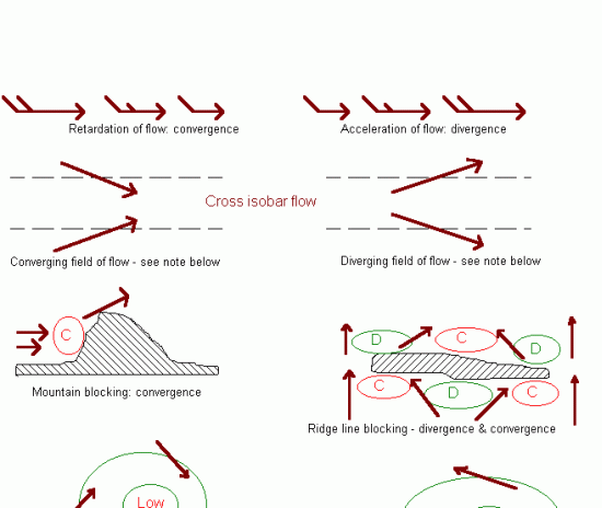
Note: referring to the field of
flow diagrams above, the spreading apart (diffluence) and the closing together
(confluence) of streamlines alone do not imply existence of divergence or
convergence as there is no change in air mass if there is no cross isobar flow
or vertical flow. (An isobar is a curve along which pressure is constant and
is usually drawn on a constant height surface such as mean sea level.)
Divergence or convergence may be induced by a change in surface drag, for
instance when an airstream crosses a coastline. An airstream being forced up by
a front will also induce convergence. For convergence / divergence in upper
level waves. Some divergence / convergence effects may cancel each other out
e.g. deceleration associated with diverging streamlines.
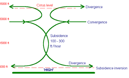
Developing anti-cyclones – “highs” and high pressure ridges, are associated with
converging air aloft and consequent wide area subsidence with diverging air
below . This subsidence usually occurs between 20 000 and 5000 feet typically at
the rate of 100 – 200 feet per hour. The subsiding air is compressed and warmed
adiabatically at the DALR, or an SALR, and there is a net gain of mass within
the developing high. Some of the converging air aloft rises and, if sufficiently
moist, forms the cirrus cloud often associated with anti-cyclones.
As the
pressure lapse rate is exponential and
the DALR is linear the upper section of a block of subsiding air usually sinks
for a greater distance and hence warms more than the lower section and if the
bottom section also contains layer cloud the sinking air will only warm at a
SALR until the cloud evaporates. Also when the lower section is nearing the
surface it must diverge rather than descend and thus adiabatic warming stops.
With these circumstances it is very common for a subsidence inversion to
consolidate at an altitude between 3000 and 6000 feet. The weather associated
with large scale subsidence is almost always dry, but in winter persistent low
cloud and fog can readily form in the stagnant air due to low thermal activity
below the inversion, producing ‘anti-cyclonic gloom’. In summer there may be a
haze layer at the inversion level which reduces horizontal visibility at that
level although the atmosphere above will be bright and clear. Aircraft climbing
through the inversion layer will usually experience a wind velocity change.
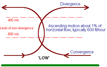
Developing cyclones, “lows” or "depressions",
and low pressure troughs are associated with diverging air aloft and uplift of
air leading to convergence below. There is a net loss of mass within an
intensifying low as the rate of vertical outflow is greater than the horizontal
inflow, but if the winds continue to blow into a low for a number of days,
exceeding the vertical outflow, the low will fill and disappear. The same does
not happen with anti-cyclones which are much more persistent.
A trough may move with pressure falling ahead of
it and rising behind it giving a system of pressure tendencies due to the motion
but with no overall change in pressure, i.e. no development, no deepening and no
increase in convergence.
thunderstorms
Like CU, surface heating, may
provide the initial trigger to create isolated CB within an air mass but the
initial lift is more likely to be provided by orographic ascent or convergence
effects.
In the formative stages of a CB
the cloud may have an updraught pulse of 1000 – 2000 feet/min, the rising parcel
of air reaches altitudes where it is much warmer than the surrounding air, by as
much as 10 °C, and buoyancy forces accelerate the parcel aloft possibly reaching
speeds of 3000 – 7000 feet/min. Precipitation particles grow with the cloud
growth, the upper levels of the cloud gaining additional energy from the latent
heat released from the freezing of droplets and the growth of snow crystals and
hailstones. When the growth of the particles is such that they can no longer be
suspended in the updraught, precipitation, and its associated drag downdraught,
occurs.
If the updraught path is tilted,
by wind shear or veer, rather than vertical, then the precipitation and its
downdraught will fall away from the updraught rather than back down through it
(consequently weakening, or stopping, the updraught) and a co-existing updraught/downdraught
may become established. An organised cell system controlling its environment and
lasting several hours may evolve.
Middle level dry air from
outside the cloud is entrained into the downdraught of an organised cell. The
downdraught is further cooled by the dry inflow air evaporating some of its
water and ice crystals and tends to accelerate downwards in vertical gusts and,
at the same time, maintaining the higher horizontal momentum it gained at upper
levels from the higher forward speed of the storm at that height. When the cold
plunging air nears the surface the downburst spreads out in all
directions as a cold gust front or squall, strongest at the leading edge of the
storm, weakest towards the trailing edge.
Anvils may take several forms:
Cumuliform: forms when a very strong updraught spreads rapidly and
without restriction.
Incus: a severe storm attains maximum vertical development when the
updraught reaches a stable layer which it is unable to break through, often the
tropopause, and the cloud top spreads horizontally in all directions forming an
overhanging anvil.
Back-sheared: the cloud top spreads upwind, against the high level
flow and indicating a very strong updraught.
Mushroom: a rollover or lip around the underside of an overhanging
anvil indicating rapid expansion.
Overshooting top: a dome-like protusion through the top of an anvil
indicating a very strong updraught pulse. The overshooting top in large tropical
storms has been known to develop into a 'chimney' towering maybe 10 000 feet
into the stratosphere with an extensive plume cloud extending downwind from its
top. Such clouds transfer moisture to the stratosphere.
Each organised cell system
contains an updraught / downdraught core beneath which is the outflow
region containing the rain shield and bounded by the downdraught gust
front, a flanking line with a dark flat base underneath which is the
inflow region of warm moist air and a spreading anvil. The CU and
TCU generated by the inflow within the flanking line are the genesis of new
cells. Within the core the condensation of moisture from the inflow region
produces rain, hail and snow and the associated downdraught to the outflow
region. When the cool air outflow exceeds and finally smothers ,or undercuts and
chokes off, the inflow the storm dissipates.
High moisture content in the low
level air with dry mid level air plus atmospheric instability are required to
maintain CB development. The amount of precipitation from a large storm is
typically 200 000 tonnes but severe storms have produced 2 million tonnes.
