
humidity, temperature and stability
our thanks
www.raa.asn.au
(Copyright John Brandon)
Insolation
The
earth’s surface and the atmosphere are mainly warmed by insolation –
incoming solar electromagnetic radiation. The amount of insolation energy
reaching the outer atmosphere is about 1.36 kilowatts per m². About 10% of the
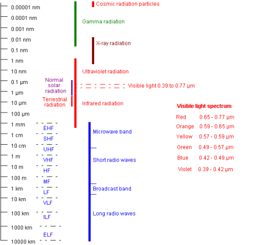
radiation is in the near end of the ultraviolet range ( 0.1 to 0.4
microns), 40% in the visible light range ( 0.4 to 0.7 µm ), 49% in the
short wave infra-red range ( 0.7 to 3.0 µm ) and 1% is higher energy and
X-ray radiation. Refer 1.8 below. The X-rays are blocked at the outer atmosphere
and most of the atmospheric absorption of insolation takes place in the upper
stratosphere and the thermosphere; with little direct insolation warming in the
troposphere, which is mostly warmed by contact with the surface and subsequent
convective and mechanical mixing: refer 1.7.4 below.
On a sunny day 75% of insolation may reach the earth’s surface; on an overcast
day only 15%. On average 51% of insolation is absorbed by the surface as thermal
energy – 29% as direct radiation and 22% as diffused radiation; i.e. scattered
by atmospheric dust , water vapour and air molecules, refer 12.1. About 4% of
the radiation reaching the surface is directly reflected, at the same
wavelength, from the surface back into space. Typical surface reflectance values
(albedo) are shown below:
|
Soils |
5–10% |
|
Snow, dependent on age |
40–90% |
|
Desert |
20–40% |
|
Water, sun high in sky |
2–10% |
|
Forest |
5–20% |
|
Water, sun low in sky |
10–80% |
|
Grass |
15–25% |
|
|
|
In the insolation input diagram shown below it can be seen that about 26% of
insolation is directly reflected back into space by the atmosphere but 19% is
absorbed within it as thermal energy with much of the UV radiation being
absorbed within the stratospheric ozone layer. Clouds reflect 20% and absorb 3%,
atmospheric gases and particles reflect 6% and absorb 16%.
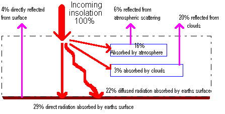
Altogether some 70% of
insolation is absorbed at the earth’s surface and in the upper atmosphere but
eventually all this absorbed radiation is re-radiated back into space as long
wave ( 3 to 30 µm ) infra-red. The result of radiation absorption and
re-radiation is that the mean atmospheric surface temperature is maintained at
15 °C.
Terrestrial radiation
The surface/atmosphere
radiation emission diagram below shows that some 6% of input is lost directly to
space as long wave IR from the surface. Atmospheric O², N², and Ar cannot absorb
the long wave radiation, also there is a window in the radiation spectrum
between 8.5 µm and 11 µm where IR radiation is not absorbed to any great extent
by the other gases. About 15% of the received energy is emitted from the surface
as long wave radiation and absorbed by water vapour and cloud droplets within
the troposphere and by CO² in the mesosphere. This is actually a net 15%, the
total being much greater but the remainder is counter balanced by downward long
wave emission from the atmosphere.
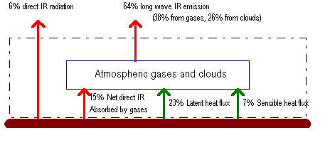
Radiation emitted upwards into space,
principally nocturnal cooling, is re-radiated from clouds (26%) plus water
vapour, O³ and CO² (38%). The atmosphere then has a net long wave energy
deficit, after total upwards emission (64%) and absorption (15%), equivalent to
49% of solar input and a short wave insolation excess of 19% (16% + 3% absorbed)
resulting in a total atmospheric energy deficit equivalent to 30% of insolation.
Energy balance
The surface has a radiation
surplus of 30% of solar input, 51% short wave absorbed less 21% long wave
emitted. This surplus thermal energy is convected to the atmosphere by sensible
heat flux (7%) and by latent heat flux (23%). The latent heat flux is greater
because the ratio of global water to land surface is about 3:1 and over oceans
possibly 90% of the heat flux from the surface is in the form of latent heat.
Conversely over arid land practically all heat transfer to the atmosphere is in
the form of sensible heat.
Overall the earth-atmosphere radiation/re-radiation system is in balance but
between latitudes 35°N and 35°S more energy is stored than re-radiated, thus an
energy surplus, while between the 35° latitudes and the poles there is a
matching energy deficit. There is also a diurnal and a seasonal variation in the
radiation balance. The average daily solar radiation measured at the surface in
Australia is 7.5 kW hours/m² in summer and 3.5 kW hours/m² in winter.
All substances emit electromagnetic
radiation in amounts and wavelengths dependent on their temperature. The hotter
the substance the shorter will be the wavelengths at which maximum emission
takes place. The sun, at 6000 K gives maximum emission at about 0.5 µm in the
visible light band. The earth at 288 K gives maximum emission at about 9 µm in
the long wave IR band.
Tropospheric transport of
surface heating and cooling
The means by which surface
heating or cooling is transported to the lower troposphere are:
 by conduction – air
molecules coming into contact with the heated (cooled) surface are themselves
heated (cooled) and have the same effect on adjacent molecules, thus an air
layer only a few centimetres thick becomes less (more) dense than the air
above.
by conduction – air
molecules coming into contact with the heated (cooled) surface are themselves
heated (cooled) and have the same effect on adjacent molecules, thus an air
layer only a few centimetres thick becomes less (more) dense than the air
above.
by convective mixing –
arising when the heated air layer tries to rise and the denser layer above
tries to sink, thus small turbulent eddies build and the heated layer expands
from a few centimetres to a layer hundreds, or thousands, of feet deep
depending on the intensity of solar heating. Convective mixing is more
important than mechanical mixing for heating air and is usually dominant
during daylight hours.
by mechanical mixing –
where wind flow creates frictional turbulence. Mechanical mixing dominates
nocturnally when surface cooling and conduction create a cooler, denser layer
above the surface thus stopping convective mixing. If there is no wind
mechanical mixing can’t occur.
The term (planetary) boundary
layer is used to describe the lowest layer of the atmosphere, roughly 1000
to 6000 feet thick, in which the influence of surface friction on air motion is
important. It is also referred to as the friction layer or the mixed layer.
The boundary layer will equate with the mechanical mixing layer if the air is
stable and with the convective mixing layer if the air is unstable. The term
surface boundary layer or surface layer is applied to the thin layer
immediately adjacent to the surface, and part of the planetary boundary layer,
within which the friction effects are more or less constant throughout, rather
than decreasing with height, and the effects of daytime heating and night time
cooling are at a maximum. The layer is roughly 50 feet deep, varying with
conditions.
1.7.5 Heat advection
Advection is transport of heat,
moisture and other air mass properties by horizontal winds.
-
Warm advection
brings warm air into a region.
-
Cold advection
brings cold air into a region.
-
Moisture advection
brings moister air and is usually combined with warm advection.
-
Advection is positive
if higher values are being advected towards lower, negative if lower
values are being advected towards higher, e.g. cold air moving into a warmer
region.
Advection into a region may vary
with height, e.g. warm, moist advection from surface winds while upper winds are
advecting cold, dry air.
Electromagnetic wave spectrum
The electromagnetic spectrum
stretches over 60 octaves, the wavelengths double 60 times from the shortest to
the longest. In a vacuum electromagnetic waves propagate at a speed close to 300
000 km/sec. The frequency can be calculated from the wavelength ( frequency x
wavelength = 108 m/sec ) thus:
-
Frequency in kHz = 300
000/wavelength in metres
-
Frequency in MHz =
300/wavelength in metres or 30 000/ wavelength in centimetres
-
Frequency in GHz =
30/wavelength in centimetre
The very high frequency [VHF]
band used in civil aviation radio communications lies in the 30 to 300 MHz
frequency range thus the 10 metre to 1 metre wavelength range. The other civil
aviation voice communications band is in the high frequency [HF] range; 3 – 30
MHz or 100 –10 metre.
The amplitude of the wave is
proportional to the energy of vibration. The table below shows the wave length
ranges – beginning in nanometres [nm] and progressing through micrometres,
millimetres, metres and kilometres – and the associated radiation bands.
Tropospheric global heat transfer
Precipitation is less than
evaporation between 10° and 40° latitudes, the difference being greatest at
about 20°. Polewards and equatorwards of these bands precipitation is greater than
evaporation. The transfer of atmospheric water vapour, containing latent heat,
is polewards at latitudes greater than 20° and equatorwards at lower latitudes.
Most of the vertical heat transfer is in the form of latent heat but possibly
65% of the atmospheric horizontal transfer is in the form of sensible heat
following condensation of water vapour. Horizontal latent heat transfer occurs
primarily in the lower troposphere.
The general wind circulation within the troposphere ( refer 4.1 ) and the water
circulation within the oceans transfer heat from the energy surplus zones (
refer 1.7 ) to the energy deficit zones thereby maintaining the global heat
balance. About 70% is transferred by the atmosphere and 30% by the oceans. The
large mid-latitude eddies, the cyclones and anti-cyclones in the broad westerly
wind band that flows around the Southern Hemisphere, play a particularly
important part in the transfer of the excess heat energy from low to high
latitudes and in the mixing of cold Antarctic or arctic air into the
mid-latitudes.
Temperature lapse rates in the troposphere
The temperature lapse rates in
the troposphere vary by latitude, climatic zone and season, varying between less
than 0 °C/km (i.e. increasing with height) at the winter poles to more than 8
°C/km over a summer sub-tropical ocean. In the mid-latitudes the temperature
reduces with increasing height at varying rates but averaging 6.5 °C/km or about
2 °C per 1000 feet, although within any tropospheric layer temperature may
actually increase with increasing height. This reversal of the norm is a
temperature inversion condition. Should the temperature in a layer remain
constant with height then an isothermal layer condition exists. At night,
particularly under clear skies, the air in the mixed layer cools considerably
but the long wave radiation from the higher levels is weak and the air there
cools just 1 °C or so. Consequently a nocturnal inversion forms over the
the mixed layer, the depth of which depends on the temperature drop and the
amount of mechanical mixing.
Tropospheric average temperature lapse rate
profile
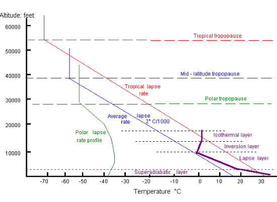
The altitude of the tropopause,
and thus the thickness of the troposphere, varies considerably. Typical
altitudes are 55 000 feet in the tropics with a temperature of –70 °C and 29 000
feet in polar regions with a temperature of –50 °C. Because of the very low
surface temperatures in polar regions and the associated low level inversion,
the temperature lapse profile is markedly different to the mid-latitude norms.
In mid-latitudes the height of the troposphere varies seasonally and daily with
the passage of high and low pressure systems.
In the chart above an exaggerated environmental temperature lapse rate profile
has been superimposed to illustrate the temperature layer possibilities starting
with a superadiabatic lapse layer at the surface, a normal lapse rate layer
above it then a temperature inversion layer and an isothermal layer.
Adiabatic processes and lapse
rates
An adiabatic process is a
thermodynamic process where a change occurs without loss or addition of heat, as
opposed to a diabatic process in which heat enters or leaves the system.
Examples of the latter are evaporation from the ocean surface, radiation
absorption and turbulent mixing.
An adiabatic temperature change occurs in a vertically displaced parcel of air
due to the change in pressure and volume occurring during a short time period,
with little or no heat exchange with the environment. Upward displacement and
consequent expansion causes cooling, downward displacement and subsequent
compression causes warming. In the troposphere the change in temperature
associated with the vertical displacement of a parcel of dry ( i.e. not
saturated ) air is very close to 3 °C per 1000 feet, or 9.8 °C / km, of vertical
motion; this is known as the dry adiabatic lapse rate [DALR]. As
ascending moist air expands and cools in the adiabatic process the excess water
vapour condenses after reaching dewpoint and the latent heat of condensation is
released into the parcel of air as sensible heat thus slowing the pressure
induced cooling process. This condensation process continues whilst the parcel
of air continues to ascend and expand. The process is reversed as an evaporation
process in descent and compression. The adiabatic lapse rate for saturated air,
the saturated adiabatic lapse rate [SALR], is dependent on the amount of
moisture content which in itself is dependent on temperature and pressure. The
chart below shows the SALR at pressures of 500 and 1000 mb and temperatures
between –40 °C and +40 °C.
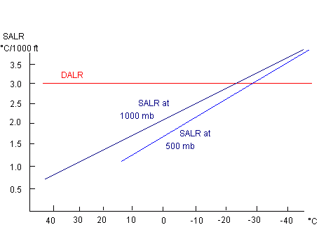
The chart shows that on a warm
day the SALR near sea level is about 1.2 °C / 1000 feet while at about 18 000
feet, the 500 mb level, the rate doubles to about 2.4 °C / 1000 feet.
The environment lapse rate [ELR] is ascertained by measuring the actual
vertical distribution of temperature at that time and place. The ELR may be
equal to or differ from the DALR or SALR of a parcel of air moving within that
environment. In the atmosphere parcels of air are stirred up and down by
turbulence and eddies that may extend several thousand feet vertically in most
wind conditions. These parcels mix and exchange heat with the surrounding air
thus distorting the adiabatic processes.
If the rate of ground heating by solar radiation is rapid the mixing of heated
bubbles of air may be too slow to induce a well mixed layer with a normal DALR.
The ELR, up to 2000 – 3000 feet agl, may be much greater than the DALR. Such a
layer is termed a superadiabatic layer and will contain strong thermals
and downdraughts.
Atmospheric stability
Atmospheric stability is the
air’s resistance to any disturbing effect but might be defined as the ability to
resist the narrowing of the spread between air temperature and dewpoint.
Stable air cools slowly with height and vertical movement is limited. If a
parcel of air, after being lifted, is cooler than the environment, the parcel
being more dense than the surrounding air will tend to sink back and conditions
are stable.
The temperature of unstable air drops more rapidly with increase in altitude
i.e. the ELR is steep. If a lifted parcel is warmer, and thus less dense than
the surrounding air, the parcel will continue to rise and conditions are
unstable. Unstable air, once it has been lifted to the lifting
condensation level ( refer 3.3 ) keeps rising through free convection.
Instability can cause upward or downward motion. When saturated air containing
little or no condensation is made to descend then adiabatic warming causes the
air to become unsaturated almost immediately and further descent warms it at the
DALR.
If the ELR lies between the DALR and the SALR a state of conditional
instability exists. Thus if an unsaturated parcel of rises from the surface
it will cool at the DALR and so remain cooler than the environment and
conditions are stable. However if the parcel passes dewpoint during the ascent
it will then cool at a slower rate and, on further uplift, become warmer than
the environment and so become unstable. High dewpoints are an indication of
conditional instability. The figure below demonstrates some ELR states with the
consequent stability condition:
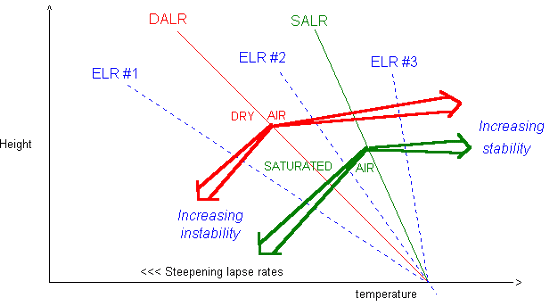
-
ELR #1 is much greater than
the DALR (and the SALR) providing absolute instability. This condition is
normally found only near the ground in a superadiabatic layer.
-
ELR # 2 between the DALR and
the SALR demonstrates conditional instability. It is stable when the air
parcel is unsaturated, i.e. the ELR is less than the DALR, and unstable when
it is saturated, i.e. the ELR is greater than the SALR.
-
ELR #3 indicates absolute
stability, the ELR is less than the SALR (and the DALR).
-
Neutral equilibrium
would exist if the ELR equalled the SALR and the air was saturated or if the
ELR equalled the DALR and the air was unsaturated.
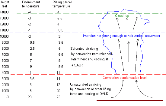
The following diagram is an
example of atmospheric instability and cloud development, comparing environment
temperature and that of a rising air parcel with dewpoint of 11 °C.
The amount of energy that could
be released once surface based convection is initiated in humid air is measured
as convective available potential energy [CAPE]. CAPE is measured in
joules per kilogram of dry air and may be assessed by plotting the vertical
profile of balloon radio-sonde readings for pressure, temperature and humidity
on a tephigram and also plotting the temperatures that a rising parcel of air
would have in that environment.. On the completed tephigram the area between the
plot for environment temperature profile and the plot for the rising parcel
temperature profile is directly related to the CAPE, which in turn is directly
related to the maximum vertical speed in a Cb updraught.
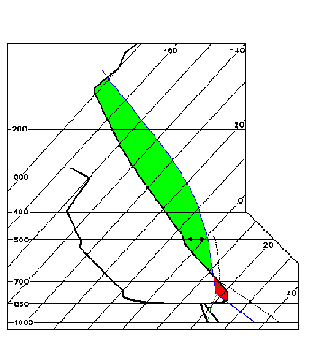
A tephigram is a
thermodynamic graph used by meteorologists for plotting atmospheric temperature
and moisture profiles. The name is a combination of T, for temperature and the
Greek letter phi, for entropy, the latter roughly meaning, in this context, the
potential energy of a gas. A simplified tephigram is shown below with just
isobars – the horizontal lines and isotherms – the diagonal lines, and a plot of
dewpoint on the left. The observed temperature profile is in the centre and the
expected rising parcel temperature profile is to the right of it with the amount
of CAPE related to the area between the plots.
Convergence, divergence and subsidence
Synoptic scale atmospheric
vertical motion is found in cyclones and anticyclones, mainly caused by air mass
convergence or divergence from horizontal motion. Meteorological convergence
indicates retardation in air flow with increase in air mass in a given volume
due to net three dimensional inflow. Meteorological divergence, or
negative convergence, indicates acceleration with decrease in air mass.
Convergence is the contraction and divergence is the spreading of a field of
flow.
If, for example, the front end of moving air mass layer slows down, the air in
the rear will catch up – converge, and the air must move vertically to avoid
local compression. If the lower boundary of the moving air mass is at surface
level all the vertical movement must be upward. If the moving air mass is just
below the tropopause all the vertical movement will be downward because the
tropopause inhibits vertical motion. Conversely if the front end of a moving air
mass layer speeds up then the flow diverges. If the air mass is at the surface
then downward motion will occur above it to satisfy mass conservation
principles, if the divergence is aloft then upward motion takes place.
Rising air must diverge before it reaches the tropopause and sinking air must
diverge before it reaches the surface. As the surface pressure is the weight per
unit area of the overlaying column of air, and even though divergences in one
part of the column are largely balanced by convergences in another, the slight
change in mass content (thickness) of the over-riding air changes the pressure
at the surface.
The following diagrams illustrate some examples of convergence and divergence:
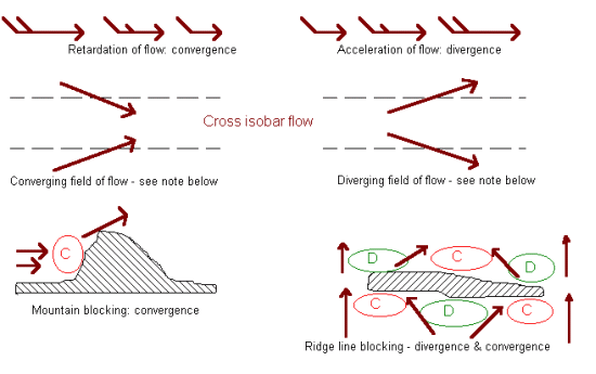
Note: referring to the field of
flow diagrams above, the spreading apart (diffluence) and the closing
together (confluence) of streamlines alone do not imply existence of
divergence or convergence as there is no change in air mass if there is no cross
isobar flow or vertical flow. (An isobar is a curve along which
pressure is constant and is usually drawn on a constant height surface such as
mean sea level.)
Divergence or convergence may be induced by a change in surface drag, for
instance when an airstream crosses a coastline. An airstream being forced up by
a front will also induce convergence. For convergence / divergence in upper
level waves. Some divergence / convergence effects may cancel each other out
e.g. deceleration associated with diverging streamlines.
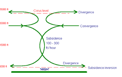
Developing anti-cyclones – “highs” and high pressure ridges, are
associated with converging air aloft and consequent wide area subsidence with
diverging air below . This subsidence usually occurs between 20 000 and 5000
feet typically at the rate of 100 – 200 feet per hour. The subsiding air is
compressed and warmed adiabatically at the DALR, or an SALR, and there is a net
gain of mass within the developing high. Some of the converging air aloft rises
and, if sufficiently moist, forms the cirrus cloud often associated with
anti-cyclones.
As the
pressure lapse rate is exponential and
the DALR is linear the upper section of a block of subsiding air usually sinks
for a greater distance and hence warms more than the lower section and if the
bottom section also contains layer cloud the sinking air will only warm at a
SALR until the cloud evaporates. Also when the lower section is nearing the
surface it must diverge rather than descend and thus adiabatic warming stops.
With these circumstances it is very common for a subsidence inversion to
consolidate at an altitude between 3000 and 6000 feet. The weather associated
with large scale subsidence is almost always dry, but in winter persistent low
cloud and fog can readily form in the stagnant air due to low thermal activity
below the inversion, producing ‘anti-cyclonic gloom’. In summer there may be a
haze layer at the inversion level which reduces horizontal visibility at that
level although the atmosphere above will be bright and clear. Aircraft climbing
through the inversion layer will usually experience a wind velocity change.
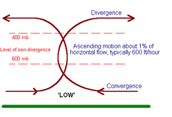
Developing cyclones,
“lows” or "depressions" and low pressure troughs are associated with diverging
air aloft and uplift of air leading to convergence below. There is a net loss of
mass within an intensifying low as the rate of vertical outflow is greater than
the horizontal inflow, but if the winds continue to blow into a low for a number
of days, exceeding the vertical outflow, the low will fill and disappear. The
same does not happen with anti-cyclones which are much more persistent.
A trough may move with pressure
falling ahead of it and rising behind it giving a system of pressure tendencies
due to the motion but with no overall change in pressure, i.e. no development,
no deepening and no increase in convergence.
Thermal
gradients and the thermal wind concept
The rate of fall in pressure
with height is less in warm air than in cold and columns of warm air have a
greater vertical extent than columns of cold air. Consider two adjacent air
columns having the same msl pressure; the isobaric surfaces (surfaces of
constant pressure) are at higher levels in the warm air column which result in a
horizontal pressure gradient from the warm to the cold air, which
increases with height, i.e. the temperature gradient causes increasing wind to
higher levels. The horizontal pressure gradient increases as the horizontal
thermal gradient increases, the process being known as the thermal wind
mechanism.
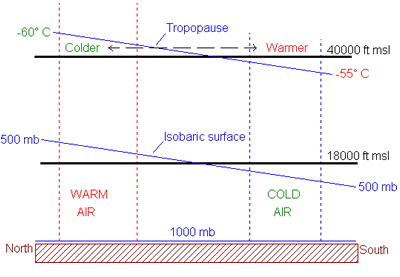
The isobaric surface contours
vary with height so the geostrophic wind velocity above a given point also
varies with height. The wind vector difference between the two levels above the
point, the vertical wind shear, is called the thermal wind, i.e. the wind
vector component caused by temperature difference rather than pressure
difference. On an upper air thickness chart which indicates the heat
content of the troposphere, the thermal wind is aligned with the geopotential
height lines or with the isotherms on an upper air constant pressure level
chart (isobaric surface chart), and the thicker (warmer) air is to
the left looking downwind.
A geopotential height line is a
curve of constant height, i.e. the height/thickness contours relating to an
isobaric surface, usually shown in decametres or metres above the 1000 mb
surface or msl on an upper air chart. An isotherm is a curve connecting
points of equal temperature and usually drawn on a constant pressure surface or
a constant height surface An isopleth is the generic name for all iso-lines
or contour lines.
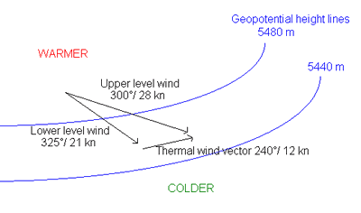
The speed of the thermal wind is
proportional to the thermal gradient, the closer the contour spacing the
stronger the thermal wind. If the horizontal thermal gradient maintains much the
same direction through a deep atmospheric layer, for instance there are no upper
level highs or lows, and the gradient is strong with the colder air to the
south, then the thermal wind will increase with height eventually becoming a
constant westerly vector. The resultant high level wind will be high speed and
nearly westerly.
Generally colder air is to the south so that the thermal wind vector tends
westerly but if the horizontal thermal gradient reverses direction with height
an easterly thermal wind will occur above that level and the upper level
westerly geostrophic wind speed will decrease with height. Since the direction
of the thermal gradient is reversed above the tropopause the thermal wind
reverses to easterly. The horizontal thermal gradient is at maximum just below
the tropopause, where the jet stream occurs.
At latitude 45° S a temperature difference of 1 °C in 100 km will cause an
increase in thermal wind of 10 m/sec, or about 20 knots, for every 10 000 feet
of altitude, giving jet stream speeds at 30 000 feet, ignoring geostrophic wind.
Temperature contrasts between air masses at the polar front will be greatest
during winter, giving the strongest jet stream.
|
