
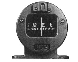
magnetic compass
The
magnetic compass is the only instrument in the aircraft by which the
pilot determines the direction of flight. Magnets in the compass cause
it to align with the Magnetic North Pole. It is nearly always fitted on
top of the visor that shades the instrument panel or is hung from the
top of the windshield frame in order to keep it as far away from
electrical gear as possible.
The compass
card has the four cardinal headings shown as N, E, S, and W. Numbers appear
every 30 degrees. Long vertical marks occur in 10 degree increments, with
intervening short marks at 5 degree points. The compass card containing the
magnets are mounted on a small pivot point in the centre of the card assembly.
This allows the compass card to rotate and float freely. It is somewhat like
suspending a paper cup, upside down, on a pencil point located at the centre of
the cup bottom.
The
enclosure is filled with white kerosene to provide a medium to dampen out some
vibration and unwanted oscillations. A "lubber line" in etched on the glass face
of the instrument to enable exact reading of the compass.
Magnets in
the compass align themselves along a Magnetic North-South orientation. Whenever
the aircraft is headed toward magnetic North, the compass will indicate N. If
the aircraft turns from this direction, the magnets in the compass still
align to this N-S direction. Similar to a gyro, the case of the compass and the
lubber line is fixed to the aircraft. Thus when the airplane turns, the the case
turns about the compass card. The lubber line will then show a reading other
than North.
Compass
Errors
Magnetic lines of force surround the Earth, flowing from the North to
South Magnetic poles. The magnetic field strength is greatest near the
magnetic poles and weakest at the Equator. Several compass errors can
occur.
These are:
1.
Magnetic Variation
2. Compass Deviation
3. Magnetic dip
4. Compass Card oscillation
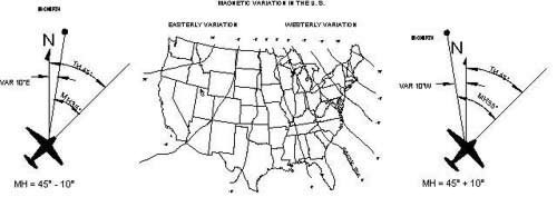
Magnetic Variation
The
Magnetic North Pole and the True North Pole are not at the
same location on the surface of the earth. Magnetic Variation at
any given location on the earth’s surface is the difference between the
Compass North and True North. The map below shows the
magnetic variation at various locations in the US.
The
Agonic Line is the line of zero degree variation. It proceeds from upper
Michigan through central South Carolina. Variation values to the East of the
agonic line are called Westerly Variation; i.e. the magnetic north pole
is West of True North. Likewise, the variation values west of the agonic
line are known as Easterly Variation; i.e. the Magnetic North Pole is
East of True North.
Magnetic
North changes in small amounts each year. Aeronautical charts are updated
periodically to correct for this yearly change.
When
plotting a course on an aeronautical chart, the degrees of heading are measured
against latitude and longitude lines. This is called a True Course (TC)
because it is being measured relative to the True North Pole. Since the
pilot relies on the magnetic compass for direction, the pilot will be steering
the aircraft relative to the Magnetic North Pole. Therefore, the pilot
must convert the True Course (TC), as plotted on the navigation chart, to a
Magnetic Course (MC) by which to steer using the compass. . To convert from TC
to MC, Westerly Variations must be ADDED to TC to get MC (see right hand
example below). MC = TC + VAR. (MC = 45° + 10° = 55°). In other words, the pilot
must steer 55° magnetic to fly over a true course of 45°. Likewise, Easterly
Variation must be SUBTRACTED from TC to get MC (see left hand example below).
Compass Deviation
Magnetic deviation is the difference between the compass indications
when installed in the aircraft compared to the indications when the
compass is outside the aircraft. The cause of this difference is that
the compass magnets can be influenced by magnetic fields within the
aircraft due to electronic equipment and other factors. These magnetic
disturbances may cause the compass readings to be slightly in error.
Such errors are called Compass Deviation.. In other words, the
compass reading when inside the aircraft "deviates" from a normal
reading.
To determine
compass deviation, the aircraft is parked on a compass rose painted on a level
surface such as a ramp or taxiway. All of the electronic equipment is powered on
as in normal operation. The nose of the aircraft is placed on the Magnetic North
marking on the ground. Deviation in the compass reading (from North) is
recorded. The aircraft is then rotated to 30 degrees to the right, and the
deviation noted. The aircraft is turned in increments of thirty degrees through
the 360 degrees, and deviation from the proper reading is noted. This procedure
is called swinging the compass. These errors are posted on a Deviation
Card placed at the lower portion of the compass. For example, it may state
for a course of 180, steer 178°.
Usually the
errors are only a few degrees, but should be taken into consideration by the
pilot then tracking a given magnetic course.
Compass Dip Errors
Any time the
compass card is not perfectly level, the magnets dip downward toward the
earth. The result is that the compass does not correctly align with Magnetic
North the same as when the card is level. This results in erroneous indication
while in the non-level state. Dip occurs under 2 conditions.
1. During turns from the north and south. (i.e. Plane is in a bank.
2. During acceleration or deceleration while on an East or West heading.
Compass Turning Errors
When
the aircraft initiates a right turn from the North, the dip of the
compass causes the compass to initially indicate a turn IN THE
OPPOSITE DIRECTION (i.e. the compass turns left). The amount of
initial error is approximately equal to the Latitude position of the
aircraft. If at a 30 degree latitude, and a right turn from North is
initiated, the compass card will initially turn LEFT to 330 degrees.
As the right turn to the EAST proceeds, the compass will start to
catch up, so that when EAST (090) degrees is reached the compass
will indicate correctly, even though the aircraft is still banked.
If the turn
is LEFT from NORTH, the compass will turn right to 030 degrees,
and will catch up by the time WEST (270) degrees is reached.
THEREFORE,
WHEN TURNING FROM NORTH, THE COMPASS LAGS. If turning to the North, you will
have to roll back to straight and level approximately 30 degrees prior to
reaching North on the compass.
When turning
from SOUTH, the opposite action occurs; the compass LEADS by the amount of the
degrees Latitude. If at 30 degrees Latitude, the lead will be approximately 30
degrees. If you are turning to the South, you will have to roll back to straight
and level approximately 30 degrees past South reading.
MEMORY
AID: Turn to N, Under Shoot. Turn to South, Over Shoot.
Compass Acceleration Errors
When
the aircraft is on an East or West heading, acceleration or deceleration
of the aircraft causes the compass card to tilt forward or backward,
respectively. This tilting causes the compass card magnets to swing
downward toward the earth, which in turn causes the compass to rotate to
an incorrect indication.
This error
is maximum when on an East or West heading, and gradually diminishes to zero
when a North or South heading is reached. Acceleration of the aircraft
causes the compass to erroneously swing to the North. Deceleration
causes erroneous rotation toward the South.
Again, the
error is approximately equal to the Latitude degrees of the aircraft location.
At 30 degrees Latitude, acceleration causes the swing to a northerly reading to
be approximately 30 degrees. Once the acceleration ceases, and the aircraft
assumes a constant forward velocity, the compass will return to it’s original
East or West reading.
In like
manner, deceleration of he aircraft causes an erroneous swing to a southerly
reading of approximately 30 degrees at the same Latitude..
MEMORY
AID: A N D S - Accelerate North, Decelerate South
|
