
problems in the mountainsOccasionally the wind defies all common sense
reasoning and visualization. When this occurs it is usually due to one or
a combination of the following:
- subsidence
- inversion
- terrain modification
- valley
breeze
- mountain
breeze
Circulation
(This discussion is
limited to the northern hemisphere)
A quick review of some basic weather
phenomena helps make the point. Circulation refers simply to the
movement of air about the earth's surface. The sun heats the Earth's
surface unevenly. The most direct rays strike near the equator, heating
the equatorial regions more than the polar regions. The equatorial region
re-radiates to space less heat than is received from the sun, while the
reverse is true at the poles.
Yet the equator does not continue to get hotter
and hotter, nor does the polar region get colder. The only explanation is
that heat is transferred from one latitude to another by the actual
transport of air.
Warm air forced aloft at the equator begins to
move north at high elevation. Coriolis force turns it to the right (east).
This turning develops a strong band of winds, "prevailing westerlies," at
about 30º north latitude.
Similarly, cool air from the poles begins a
low-elevation journey toward the equator. It is also deflected to its
right by Coriolis force creating a belt of low-level "polar easterlies."
The result is to create an temporary impasse that disrupts simple,
convective transfer.
The atmosphere seeks stability and in an
attempt to reach equilibrium, huge masses of air overturn in the middle
latitudes. Cold air masses break through the barriers, plunging southward.
The result is a mid-latitude bank of migratory storms with ever-changing
weather.
Air Mass
The large air masses are high pressure areas.
In the northern hemisphere, high pressure areas circulate in a clockwise
direction. The high pressure system depicted on weather maps should be
visualized as a mountain of air. The mountain is composed of isobars or
lines of equal pressure. Consider the isobars as topographic in nature. If
they are far apart, the high pressure area has a shallow topography. When
close together, there is a very steep slope to the mountain of
air.
Where isobars are close together it indicates
the air is squeezed into a smaller, more confined area with a steep slope
creating a rapid flow of air and strong surface winds.
Between the high pressure areas will be areas
of low pressure where the air flows counter-clockwise. Visualize the low
pressure area as a valley between air masses.
None of the pressure areas are stagnant. The
earth's atmosphere is in a constant state of imbalance, but there is
always a tendency to regain a state of balance.
Wind
Three forces act on wind. The pressure gradient
force drives the wind. Pressure gradient is the decrease
of pressure with distance and is in the direction of greatest decrease,
thus, pressure gradient is from higher to lower pressure and perpendicular
to the isobars. If pressure gradient was the only force acting on the
wind, wind would always blow perpendicular to the isobars.
Rotation of the earth generates a force that
deflects from a straight path any mass moving relative to the earth's
surface. Coriolis force is zero at the equator and
increases with latitude to a maximum at the poles. It is at a right angle
to wind direction and is directly proportional to wind speed. Air in
motion, due to pressure gradient, blows straight across the isobars from
higher to lower pressure. When the air is in motion, Coriolis force begins
to act at right angles to the wind, turning it to the right. Coriolis
force continues to deflect the wind until is is blowing parallel to the
isobars. Coriolis force and pressure gradient force balance, and above
surface friction (about 2,000 feet), causes the wind to blow parallel to
the isobars.
The winds at the earth's surface do not blow
parallel to the isobars. Instead, they cross the isobars at an angle from
higher to lower pressure.
Frictional
force always acts opposite to wind direction.
As friction slows the wind speed, Coriolis force decreases; however,
friction has no effect on pressure gradient force. Pressure gradient and
Coriolis forces are no longer in balance. Above 2,000 feet AGL the wind
blows parallel to isobars. Below that altitude, friction causes the
surface wind to blow 45º inward toward a low pressure area and 45º outward
from a high pressure area.
Subsidence
Variations in temperature and humidity create a
contrast in pressure and density. The pressure differences drive a complex
system of air currents in a never-ending attempt to attain
equilibrium.
Suppose an air mass (high pressure area)
arrives over the plateau area of the upper Arkansas River Valley near
Leadville, Colorado. The down flow, sinking are may be a stronger force
than the prevailing winds aloft. The pilot departing Aspen and flying up
the Roaring Fork River toward Independence Pass will be hard pressed to
find an updraft in the face of this down flow. Yet it's always been there
before. This pilot may be an accident waiting to happen.
According to Aviation Space
Environment Medicine, 232 airplanes crashed within 50 nautical miles
of Aspen, CO, between 1964 and 1987. A total of 202 people died and 69
were seriously injured. This points out the need for better training in
mountain flying.
Inversion
Often there is a layer of air within the
troposphere that is characterized by an increase of temperature with
altitude. It is called an inversion and is usually confined to a shallow
layer.
Widespread sinking air (subsidence) is heated
by compression and may become warmer than the air below it causing the
inversion. The most frequent type of inversion over land is that produced
immediately above the ground on a clear, still night. The ground loses
heat rapidly through terrestrial radiation, cooling the layer of air next
to it. Frontal inversions are also found in association with movement of
colder air under warm air or the movement of warm air over cold
air.
In a valley, expect the prevailing westerly
winds to flow down the east-facing side of the mountain on the downwind
side, pass through the valley and flow up on the west-facing upwind side
of the next mountain. An inversion may place a cap over the area
preventing the wind from flowing down the mountain. But when the wind
strikes the terrain on the downwind side of the valley, it may tuck and
move down the mountain side. With enough velocity, it may continue across
the valley and up the other side.
Terrain
Modification
fig.1
Figure 1 – Anabatic Lift
Uneven terrain features may cause the air
flow to be deflected downslope on what is considered the updraft side of
the mountain. In the absence of wind, the sun's heating of the surface
will produce convection currents known as anabatic
lift.
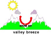
fig. 2
Figure 2 – Valley Breeze
During the day, the sun warms the valley
walls and its adjacent air. The heated air being less dense will—lacking
strong prevailing winds—rise gently upslope and is known as a
valley breeze. The east facing mountain will receive
the benefit of the sun's rays first and may cause a downslope wind on
the west-facing slope as air rushes down to fill the evacuated
air.
The valley breeze begins early in the morning
and depending on the elevation of the mountain and the heat of the sun,
may reach a peak speed of around 10 knots by noon. The significance of
this is that when landing on an airstrip in a drainage, there will be a
tailwind to contend with. The average wind speed is 6-8
knots.
fig. 3
Figure 3 - Mountain
Breeze
During the late afternoon and evening the
valley walls cool quickly, cooling a layer of air next to the slope.
This more dense air moves downslope into the valley causing the mountain breeze (gravity or drainage wind). The slopes
cool at a rate faster than they heat up, so the mountain breeze may be
stronger than the valley breeze, averaging 10-12 knots. Departing
downslope will mean the airplane may be subject to the
tailwind.
Coping
We tend to think in constants when
contemplating the weather and associate whatever is happening as affecting
a large area. Often a phenomena is isolated or may crop up in various
isolated areas. Despite what is happening or where it is happening, it is
important to visualize what is going on.
Air is fluid, similar to water—although less
dense. Ask "What would water do in this situation?" More often than not
the picture becomes clear, you will know where there are areas of lift,
sink and turbulence.
So what will happen to the pilot heading up the
Roaring Fork River toward Independence Pass? As long as he remains in a
position where he can turn to lowering terrain and does not fly beyond the
point of no return, Mother Nature will not have a chance to
perform a "got-cha."
The "point of no return" is
defined as a point on the ground of rising terrain where the terrain out
climbs the aircraft. The turn-around point is determined as the position
where, if the throttle is reduced to idle, the aircraft can be turned
around during a glide without impacting the terrain.
Never fly beyond
this point of no return. Turn around and manoeuvre for additional altitude
prior to continuing.
|
