
navigation enroute (area navigation)
RNAV
This type of navigation allows a
pilot to fly a selected course to a predetermined point without the need to
overfly ground-based navigation stations. Flight can be from waypoint to
waypoint. A waypoint is a position determined either by Latitude/Longitude or
Radial and distance from a VORTAC or VOR/DME station.
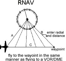
These navigation receivers
use VOR/DME or VORTAC stations as a base point. A waypoint is defined as a
distance along a radial of the VOR. The RNAV equipment electronically
translates (moves) the VOR station to the waypoint position. You then fly
the VOR as though it were located at the waypoint’s geographical location.
Through triangulation, the
navigation unit measures the radial and distance of leg A. By knowing the
entered data for leg B, the azimuth and distance to the waypoint along path C is
repeatedly calculated calculated. It is as though the VOR were located at the
waypoint position.
Long
Range Navigation (LORAN)
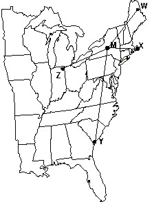
LORAN operates on the
principle of time measurement. A Master station and up to to 4 secondary
stations transmit a synchronized pulse. The time differential between the
master station pulse and the secondary pulses is measured. From this data,
the communication receiver can calculate the position of the aircraft within
0.25 Nm or better. The North East LORAN chain is shown. A database of
airports and navigational facilities can be loaded into the memory of the
LORAN unit.
The
LORAN unit can indicate:
 Present Position - in
Latitude/Longitude and/or relative to a destination, waypoint or checkpoint.
Present Position - in
Latitude/Longitude and/or relative to a destination, waypoint or checkpoint.
Bearing and distance to your
destination.
Groundspeed and estimated time
enroute.
Course Deviation Indicator.
Storage in memory of all US
airports, pilot selected fixes, minimum enroute and obstruction clearance
altitudes, and Class B and C airspace warnings.
Continuous computation of
bearings and distances to the nearest airports. Computation of wind direction
and velocity.
Add ons, such as fuel flow
analyzers to estimate fuel needed to reach destination and alternates; ELT’s
to transmit exact location of ELT.
Add-on programmable and
updatable databases.
Since LORAN operates on a
low-frequency signal, it is subject to the same disturbances that AM radio
sustains. It is possible to loose signal when operating near thunderstorm and in
heavy rain areas.
The LORAN receivers know the
frequency of the Master and secondary stations; no tuning by the pilot is
necessary.
Global Positioning System (GPS)
The GPS system is the latest in
technology that can be used by aircraft. It has many of the attributes of LORAN.
The complete system will contain up to 21 satellites in earth orbit. The
"clocks" and "positional data" is updated periodically to insure accuracy of the
data from the satellites. It sense 4 or more satellites in orbit. The system is
maintained by the US Department of Defence.
Like LORAN, it operates on a
time-based methodology. Each satellite transmits coded pulses indicating it’s
position, and the precise time the pulses are sent. The GPS unit listens to the
satellite’s signal, and measures the time between the satellites transmission
and receipt of the signal. By the process of triangulation among the several
satellites being received, the unit computes the location of the GPS receiver.
Not only can Latitude and Longitude be calculated, but altitude as well.
Like LORAN, the GPS unit
contains data about all the commercial airports in the US, including runway
lengths, directions, and location. There are numerous forms of display among the
various manufacturer. The units can range from “hand held” to “panel mount” with
altitude information input from an encoding altimeter. They can warn of Class B,
C, and Prohibited and Restricted airspace. They can calculate direction and time
to nearest suitable alternate airports in event of emergency.
The database in most units can
be updated via a connection to a Personal Computer. The maximum error is within
100 meters (0.05 Nm). Work is in progress to give the GPS system adequate
precision for instrument approaches.
No frequency tuning is required,
as the frequency of the satellite transmissions are already known by the
receiver.
Work is currently underway to
provide sufficient accuracy for use of GPS for instrument approaches.
|
