
navigation ... no easy answers (UK)
Dick Flute's recommendations for easier
and better navigation.
reproduced from GASCO
Have you ever got lost even if only
slightly? ... (Sorry, I should know better as we pilots never ever get
lost do we?). I'll start again ... have you ever been temporarily
uncertain of your position? If you can honestly answer "No" to this
question then I'll bet a penny to a pound you need to get out and about
more and consider leaving the circuit! Some pilots never leave the local
area although in my opinion the whole of southern England, or Wales or
Scotland for example can or perhaps should be regarded as a `local' area.
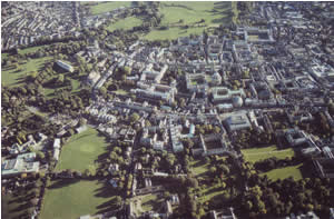
Smaller cities like Oxford with it's very
distinctive University bang in the centre
can provide ideal waypoints but there's a
lot of restricted airspace nearby to be wary
of
I was never entirely
happy with the way navigation was taught
when undergoing the PPL syllabus. It seemed
so very, very over-complicated ... surely
there was an easier way? Today of course,
(although it's sensibly
still not approved as a primary navigation
device), many dig deep into already depleted
pockets and buy a GPS. Quite frankly I think
that pretty much the whole approach to the
subject of back to basics navigation in many
flying schools let alone the PPL syllabus
leaves a lot to be desired. I approach
navigation as very much part and parcel of
the sheer fun and enjoyment of flying small
aeroplanes and you certainly won't find me
getting scorch marks on my fingers from a
quickly revolving 'Dalton' type spin-wheel
when in flight.
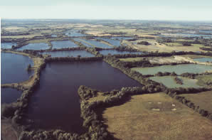
A large group of lakes like these manmade examples spread east to
south-east of Kemble airfield make brilliant navigation features, visible
when miles away (All photographs by Dick Flute.)
It's a huge problem area to say the least, much
exacerbated perhaps by junior flight instructors yearning for airline jobs
where the basics of navigation by sight, or drawing lines on charts, have
really no place at all in their thinking about navigation. They know full
well they will have copulating INS systems, cohabiting GPS, VOR etc, etc.
Why should they care about the benefits of the Didcot power station, the
Humber estuary, the Malvern Hills or the A1M/M62 interchange as primary
navigation aids? In England and Wales, (Scotland can pose different
problems of course), surely one of the big benefits is our abundance of
strong features that can be used as natural waypoints whenever possible,
even if it means flying off a straight line track to do so. The real
problem very often is recognising these features but why not plan
flights to find them deliberately?
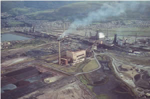
The few remaining large industrial sites in the UK, like the Port Talbot
steel works in South Wales, make excellent VFR waypoints.
Aerial Navigation isn't easy
The history of aerial navigation is a bewildering
subject at best. How on earth did Amy Johnson manage to fly to Australia?
... she could barely be regarded as even a semi-competent pilot when she
embarked on that fantastic voyage. But she didn't have areas of controlled
airspace to contend with of course. It would seem that basically Amy took
the attitude that if you fly south from Paris you'll eventually reach the
Med hopefully near Marseilles, that sort of stuff. This simple approach to
navigation can often still apply today and I still try to use it whenever
possible although she did sometimes get a bit lost trying to find her
intended landing ground. I certainly know about this problem!
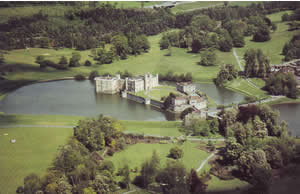
Leeds Castle in Kent near Maidstone is hard to beat, being in the middle
of a lake, but it's best if you already knew of this feature.
On the other hand, at round about the same point in
history, Francis Chichester was embarking on a project to fly a floatplane
DH Moth from New Zealand to Australia which required incredibly accurate
navigation using a sextant to get sun bearings. This is akin to proving
that bumble-bees can fly ... although it can be proved mathematically that
they can't! Surely nobody can fly a DH Moth and at the same time take
accurate bearings using a sextant? Not only did he have to find two small
islands, his compass failed whilst en route. His first leg to Norfolk
Island took 5hr 50min and to the tiny Lord Howe Island 7hr 40min and all
across a featureless ocean. He developed his own method for navigating by
the sun and after his Nautical Almanac became time expired due to other
very serious problems en route he calculated and wrote his own.
In the 1920s and early 1930s Alan Cobham was pioneering
Empire airline routes and finding fuel dumps in the middle of `nowhere' in
Africa for example without, it seems, any big problems at all. How on
earth did he achieve that?

When you can combine two, three, four or more distinctive features like
the coast plus large river estuary, railway viaduct AND a town with two
road bridges, in this case Berwick-upon-Tweed, you've usually really got
it cracked! Nothing remotely similar exists in this entire region. But
would you know this?
In the 1930s many RAF aircraft made forced landings
after embarking on navigation exercises, unable to find their way home. At
the same time commercial airlines were running pretty much scheduled
services around the UK and throughout Europe in often very marginal
weather, and with a high degree of safety. The airlines in those days
believed that learning the route in precise detail visually was if
anything more important than simply relying on the early radio navigation
aids.
The Learning Curve
I have flown with some
flying instructors who quite frankly can't
navigate unless they're playing with all the
knobs and buttons on the centre of the
instrument panel. Instructors who, it seems,
probably couldn't distinguish Aylesbury from
Zeals if their life depended on it. Surely
this is no way to go about flying little
aeroplanes VFR? Flying at fairly low
altitudes must be the real reason and
ultimate attraction for most pilots wishing
to fly, you get to see all the sights and
really appreciate the immense privilege of
being a pilot. It therefore follows that a
systematic process of deliberately planning
flights to increase your basic knowledge of
the terrain and the valuable waypoints is
surely a very sensible way to proceed.
Advice gleaned from older pilots always
seems worthwhile, like always look towards
the horizon; ranges of hills, let alone
mountains, can easily give valuable clues to
your whereabouts providing of course you've
taken the time and trouble to know a bit
about where these are and what they might
look like.
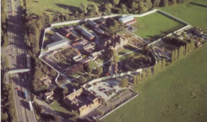
Prisons can also provide first-class waypoints. Foston Hall is alongside
and south of the A50 in Derbyshire, making it very useful ...except
there's another prison about two miles west on the north side of the A50.
Here again local knowledge, gained perhaps by regularly driving along the
A50 even though you may live a long distance away, is often essential to
avoid confusion
A coastline has long been a favourite navigation
feature to follow. But here again attention to detail is invariably needed
today as restricted airspace will probably be encountered sooner or later
which requires avoidance and/or permission to transit. As a general rule
the further you fly inland the harder navigation becomes and fixing easily
identified waypoints becomes a distinct priority. Taking care to study
charts to make sure that similar features don't exist nearby is part and
parcel of this. Here again major features on the chart like power stations
and disused airfields often need to be treated with care unless you are
already very familiar with the region. This is especially so in poor
visibility. I can testify to making a few bloomers in this regard when
utterly convinced I was dead on track. For example a helpful pilot
once told me to look out for the cooling towers, as the aerodrome was
just beyond. What he didn't I say or realise was that two sets of
cooling towers could be seen from the suggested waypoint and, at the
time I was flying, the nearest and most obvious were completely obscured
by a very heavy rain shower!
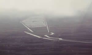
A major feature like this in the East Anglian
Fens, especially in these murky conditions, might seem very appealing and
obvious on the chart. In fact 1 can't now remember where this was exactly
but localised flooding made it look ten times more significant than it was
on the chart
Fortunately I had taken the precaution of asking a
major regional airport to provide a flight information service and the
controller very sensibly and politely asked me to verify my position....
as he could see I seemed intent on busting his airspace. The fact of the
matter was I didn't know where I was at all, although utterly convinced I
did. I had pretty much given up on the chart, could see the wrong
cooling towers and was heading straight for them. Using VOR and DME, which
is now part of the JAA PPL syllabus, can often confirm or disprove your
provisional position fix.
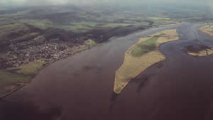
A huge river estuary such as the Tay really can't be beaten. This shot was
taken near Erroll ' airfield, now used mainly for parachuting well inland
from the coast. But what a feature!
Conclusion
I suppose the real
point I'm trying to make is that surely we
should all be taught to understand and take
advantage of every navigation method
or device available. Obviously nothing can
beat looking down, recognising unique
features and knowing from experience exactly
where we are. In real life that's not likely
to happen especially when flying well away
from home territory. For the PPL is this
problem being properly addressed in a
practical and sensible manner?
|
