
track error
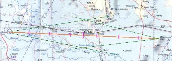
adjustmentsThe track plot below shows the first leg
of our planned flight between Oxford and Tottenham. The green lines are
the 10° drift lines and the pink marks along the track are the 10 nm
distance marks. In this example the first three marks are distance from
Oxford, the last three are distance from Warraway Mountain, and the longer
mark is the track midpoint. For the colour blind amongst us the track is
orange.
Instead of distance marks some navigators favour time marks at, say, 10
minute intervals. However time marks really don't co-relate that well with
charts – time notations are more properly confined to the log.
As it is remarkably easy to set off in the
wrong direction – reversed application of variation for instance – it is
advisable to note a landmark as a means of verifying that, at the set
course point, you really are setting off along the required track. The
sun's position provides a gross indication of heading which will at least
confirm that you are not flying the reciprocal course. Starting off in the
wrong direction, without realisation, really makes progress monitoring
difficult when you are flying over relatively featureless terrain. In
addition a position fix must be acquired within 15 to 20 minutes of the
set heading time.
At any time after departure, when the aircraft's position has been
pinpointed and found to be off track, heading adjustments will be
necessary: initially to regain the required track and then to maintain it
or, alternatively, for a new heading to track directly to the next turning
point. There are several methods for calculating and applying heading
adjustments – and I suggest you may now find pencil and paper handy.
Double track error
method
This is the recommended method if the
position fix shows the aircraft to be less than halfway along the leg –
hence the reason for marking that midpoint on the chart. The procedure is
as follows:
1. Using the diverging 10° drift lines estimate the
track error – the difference in degrees between the track required and
the track made good. The track error is also referred to as the opening
angle or sometimes as the drift angle. (The term 'drift
angle' in this context is deprecated as it normally refers to the angular
difference between the heading flown and the track made good.)
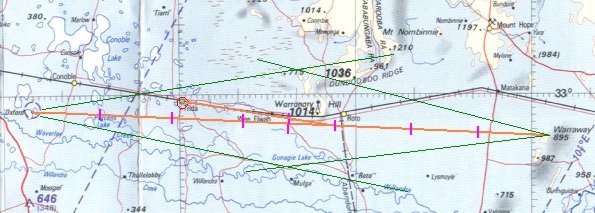
For example let's say, on our Oxford to Warraway
Mountain segment, we find ourselves crossing the railway line at Trida and
estimate the track error as 6° north of required track. i.e. the track
made good is 077° magnetic. We log the time and note 24 minutes have
lapsed since departing the set-course point.
2. Double the track error and add or subtract that value
from the planned heading to arrive at the heading to regain track
or the intercept. If the drift was to the right of track the new
heading must be to the left of the original heading and, conversely, if
drift was to the left the new heading must be to the right of the old. The
time we must remain on this new heading, until intercepting the required
track, is roughly equivalent to the time flown on the original heading.
Although we have used the terms
'left' and 'right' you will find it more helpful, when considering
position, to think in terms of 'north', 'south', south-west' etc.
For example track error is 6° north [left]
and original heading 079° magnetic, thus the heading to regain track is
079 plus 12 = 091° magnetic [096° compass] and we fly that for 24 minutes
– the same time as that flown on the original heading.
3. After it is visually evident that the required track has
been reached, or the required time has passed, subtract the track error
and turn onto the new heading to maintain the required track and log the
event.
For example the track error was 6° and the heading to regain track is 091°
magnetic, thus the heading to maintain track is 091 minus 6 = 085°
magnetic [090° compass] and we fly that until either a new position fix is
obtained or we reach the waypoint.
Theoretically this method doesn't work if the position fix is past the
halfway point because the point at which the required track is finally
regained would be past the waypoint.
Track error/closing
angle method
The recommended method if the position fix
shows the aircraft to be more than halfway along the leg, or if you choose
to fly directly to the waypoint at any time, is as follows:-
1. Using the diverging 10° drift lines estimate the track
error or opening angle – the difference in degrees between the track
required and the track made good. Then using the converging drift lines
estimate the direct track to the waypoint and the angle between that track
(the new required track) and the original required track. This is usually
called the closing angle.
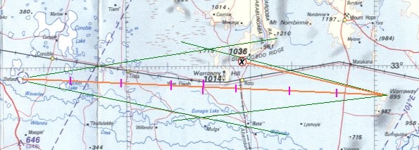
For example let's say, on our Oxford to
Warraway Mountain segment, we fix our position as one mile south of the
Dundooboo Ridge with an estimated track error of 7° north of required
track and the closing angle to the waypoint is about 9°.
2. Add the track error and closing angle and apply the
value as a correction to the original heading. If the drift was to the
left of the required track the new heading will be to the right and vice
versa.
For example 7 plus 9 is 16°, drift was to the left of the original heading
079° magnetic, thus the heading – to track directly to the waypoint – is
095° magnetic [100° compass] .
Flight direct to
landmark
A third method might be employed if after
getting a position fix a landmark known to be on, or close to, the
required track is positively identified.
Having pinpointed your position use the diverging 10° drift
lines to estimate the track error, then fly directly to the identified
on-track landmark. To maintain the required track it will be necessary to
turn onto a new heading when overhead the landmark. The new heading will
of course be the original heading plus/minus the track error.
Utilising the 1-in-60
rule
The 1-in-60 rule provides
a rule of thumb based on the reasonably accurate assumption that the sine
of any angle, up to about 45°, is equal to 0.1666 times (or 1/60) the
number of degrees. e.g sine 30° is 0.1666 x 30=0.5 or 30/60 = 0.5.
The sine is the ratio – in any roughly right angle triangle – of the
length of the side opposite the angle, to that of the hypotenuse (the
longest side), thus the 1-in-60 rule is handy in the mental arithmetic of
flight theory and basic navigation as the angles involved are usually less
than 45°. For angles up to 15° or 20° the tangent (opposite side/adjacent
side) is practically the same value as the sine.
This rule of thumb can be used to determine track error, given distance
travelled and distance off track. It replaces the use of drift lines but
the latter is much the easier method to use in flight because the angle is
easier to estimate than the on-chart distance off track, and the mental
arithmetic is easier. However, just to keep you informed, here is the
1-in-60 method for track error calculation.
1. Having pinpointed the aircraft's position, estimate the
distance off track and the distance travelled along the leg. The track
error = the distance off track [DO] divided by the distance travelled [DT]
× 60. i.e. The track error = DO/DT × 60.
Or conversely the distance off track [DO] = track error/60 × DT
For example let's revert to our Oxford to Warraway Mountain segment where,
after 24 minutes flight, we pinpoint our position at Trida. Trida is about
3 nm north of required track and 22 nm distant from the departure point.
Thus 3/22 × 60 = 8° track error. The track error we estimated using the
drift lines was 6°, but that's basic navigation for you.
2. To regain the required track double the track error and
when the required track is reached, or the time has elapsed, subtract half
the error and take up the new heading. In this aspect it's the same
technique as the double track error method.
3. Or to track direct to the next waypoint calculate the
closing angle – which will equal the distance off track [DO] divided by
the distance to go [DTG] × 60. i.e.closing angle = DO/DTG × 60.
For example Trida is 52 nm distant from Warraway Mountain. Thus 3/52 × 60
= 3° closing angle. The new heading is the original heading plus track
error plus closing angle = 079 + 8 +3 = 090° magnetic – as in the track
error/closing angle method.
Each time the aircraft's position is pinpointed and the heading is
adjusted, a re-calculation of the ground speed and ETI for the segment
should be made on the running log: the 1-in-60 rule has use in this aspect
of navigation, see section 7.4 below.
Diversions – 30° and 60° dog-legs
There is another
navigation adjustment technique occasionally mentioned as a standard
method of diversion around hazards or no-fly areas such as towns. As no
such diversions would be necessary if the flight plan is properly prepared
such techniques should be of practical use only when something of interest
is spotted off track and you divert for a little sight-seeing.
The method is as follows:
• When you judge the point of interest is about 30° off your
current heading alter course 30° towards the target. Note the time when
the target is reached and then turn 60° in the reverse direction and fly
that heading for the same time as the first part of the dog-leg, then
revert to the original heading. The time lost during the two legs, and
which has to be added to the ETI for the segment, is one third of the time
flown on the first [or either] leg, and of course you have to add to the
ETI any time spent circling over the target.
• The 60°dog-leg is much the same except that you alter course
when the target is 60° off the original heading, the alteration to return
is 120° and the time lost flying the dog-leg is the time spent on the
first [or either] leg.
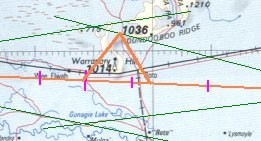
For example if we were about halfway
along our track from Oxford to Warraway Mountain and we thought it a good
idea to have a look around the Warranary Hill. Thus we turn 60° left from
our original heading of 079° magnetic to 019° magnetic, fly that for say 6
minutes then turn right 120° to 139° magnetic and fly that heading for 6
minutes. Then turn left 60° back on to our original heading of 079° and
add 6 minutes to our ETI and/or ETA.
|
