|
|
|
Both the US and the Kingdom of Hawaii
annexed Johnston Atoll in 1858, but it was the US that mined the guano
deposits until the late 1880s. Johnston and Sand Islands were designated
wildlife refuges in 1926. The US Navy took over the atoll in 1934, and
subsequently the US Air Force assumed control in 1948. The site was used for
high-altitude nuclear tests in the 1950s and 1960s, and until late in 2000
the atoll was maintained as a storage and disposal site for chemical
weapons. Munitions destruction is now complete. Cleanup and closure of the
facility is progressing, with completion anticipated in 2004. Oceania, atoll in the North Pacific Ocean
717 nm (1328 km) southwest of Honolulu, Hawaii, about one-third of the way
from Hawaii to the Marshall Islands 16 45 N, 169 31 W total: 2.8 sq
km territorial sea:
12 nm tropical, but generally dry; consistent
northeast trade winds with little seasonal temperature variation
mostly flat lowest point:
Pacific Ocean 0 m guano deposits worked until depletion
about 1890, terrestrial and aquatic wildlife no natural fresh water resources
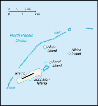
strategic location in the North Pacific
Ocean; Johnston Island and Sand Island are natural islands, which have been
expanded by coral dredging; North Island (Akau) and East Island (Hikina) are
manmade islands formed from coral dredging; the egg-shaped reef is 34 km in
circumference; closed to the public; a former US nuclear weapons test site;
site of now-closed Johnston Atoll Chemical Agent Disposal System (JACADS);
most facilities dismantled and cleanup complete in 2004; some low-growing
vegetation 396 no indigenous inhabitants unincorporated territory of the US;
administered from Honolulu, HI, by Pacific Air Forces, Hickam Air Force
Base, and the Fish and Wildlife Service of the US Department of the Interior
as part of the National Wildlife Refuge system the laws of the US, where applicable,
apply Economic activity is limited to providing
services to US military personnel and contractors located on the island. All
food and manufactured goods must be imported. general assessment:
NA Johnston Island 1 (2003 est.) total: 1 defense is the responsibility of the US
|
|
|