|
|
|
First settled
by the French in the early 17th century, the islands represent the sole
remaining vestige of France's once vast North American possessions. Northern North
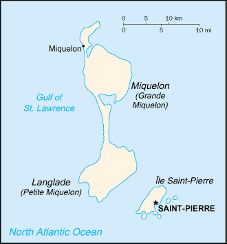
America, islands in the North Atlantic Ocean, south of Newfoundland (Canada)
46 50 N, 56 20
W total:
242 sq km territorial
sea: 12 nm cold and wet,
with much mist and fog; spring and autumn are windy mostly barren
rock lowest
point: Atlantic Ocean 0 m fish,
deepwater ports arable
land: 13.04% persistent fog
throughout the year can be a maritime hazard recent test
drilling for oil in waters around Saint Pierre and Miquelon may bring future
development that would impact the environment vegetation
scanty 6,995 (July
2004 est.) Basques and
Bretons (French fishermen) Roman Catholic
99% French
(official) self-governing
territorial collectivity of France Saint-Pierre
none
(territorial collectivity of France); note - there are no first-order
administrative divisions as defined by the US Government, but there are two
communes - Saint Pierre, Miquelon at the second order 28 September
1958 (French Constitution) French law
with special adaptations for local conditions, such as housing and taxation
The
inhabitants have traditionally earned their livelihood by fishing and by
servicing fishing fleets operating off the coast of Newfoundland. The
economy has been declining, however, because of disputes with Canada over
fishing quotas and a steady decline in the number of ships stopping at Saint
Pierre. In 1992, an arbitration panel awarded the islands an exclusive
economic zone of 12,348 sq km to settle a longstanding territorial dispute
with Canada, although it represents only 25% of what France had sought. The
islands are heavily subsidized by France to the great betterment of living
standards. The government hopes an expansion of tourism will boost economic
prospects. Recent test drilling for oil may pave the way for development of
the energy sector. 3,261 (1999)
fishing 18%,
industry (mainly fish-processing) 41%, services 41% (1996 est.) vegetables;
poultry, cattle, sheep, pigs; fish fish
processing and supply base for fishing fleets; tourism fish and fish
products, soybeans, animal feed, mollusks and crustaceans, fox and mink
pelts Zambia 35.7%,
US 24.4%, Ecuador 19.7%, France 7.3%, Canada 5.6% (2003) meat,
clothing, fuel, electrical equipment, machinery, building materials
Zambia 61.5%,
France 20%, Canada 12.3%, Italy 4.6% (2003 est.) approximately
$60 million in annual grants from France euro (EUR)
4,800 (2002)
0 (1994)
general
assessment: adequate total:
114 km Saint Pierre
none
2 (2003 est.)
total:
2 defence is the
responsibility of France |
||||||||||||||||||||||||||||||||||||||||||||||||||||||||||||||||||||||||||||||||||||||
|
|