|
|
|
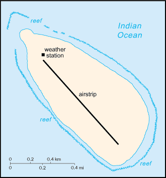
First explored by the French in 1776, the
island came under the jurisdiction of Reunion in 1814. At present, it serves
as a sea turtle sanctuary and is the site of an important meteorological
station. Southern Africa, island in the Indian
Ocean, east of Madagascar 15 52 S, 54 25 E total: 1 sq
km territorial sea:
12 nm tropical low, flat, and sandy; likely volcanic
lowest point:
Indian Ocean 0 m fish climatologically important location for
forecasting cyclones; wildlife sanctuary (seabirds, tortoises) uninhabited, except for visits by
scientists (July 2004 est.) possession of France; administered by a
high commissioner of the Republic, resident in Reunion the laws of France, where applicable,
apply no economic activity important meteorological station
none; offshore anchorage only 1 (2003 est.) |
||||||||||||||||||||||||||||||||||||
|
|