|
4-1-1.
Air Route Traffic Control Centers
Centers are established
primarily to provide air traffic service to aircraft
operating on IFR flight plans within controlled
airspace, and principally during the en route phase of
flight.
4-1-2.
Control Towers
Towers have been
established to provide for a safe, orderly and
expeditious flow of traffic on and in the vicinity of an
airport. When the responsibility has been so delegated,
towers also provide for the separation of IFR aircraft
in the terminal areas.
REFERENCE-
AIM, Approach Control, Paragraph 5-4-3.

4-1-3.
Flight Service Stations
a.
Flight Service Stations (FSS's) are air
traffic facilities which provide pilot briefings, en
route communications and VFR search and rescue
services, assist lost aircraft and aircraft in
emergency situations, relay ATC clearances, originate
Notices to Airmen, broadcast aviation weather and
National Airspace System (NAS) information, receive
and process IFR flight plans, and monitor navigational
aids (NAVAID's). In addition, at selected locations
FSS's provide En Route Flight Advisory Service (Flight
Watch), take weather observations, issue airport
advisories, and advise Customs and Immigration of
transborder flights.
b.
Supplemental Weather Service Locations
(SWSL's) are airport facilities staffed with contract
personnel who take weather observations and provide
current local weather to pilots via telephone or
radio. All other services are provided by the parent
FSS.
4-1-4.
Recording and Monitoring
a.
Calls to air traffic control (ATC)
facilities (ARTCC's, Towers, FSS's, Central Flow, and
Operations Centers) over radio and ATC operational
telephone lines (lines used for operational purposes
such as controller instructions, briefings, opening
and closing flight plans, issuance of IFR clearances
and amendments, counter hijacking activities, etc.)
may be monitored and recorded for operational uses
such as accident investigations, accident prevention,
search and rescue purposes, specialist training and
evaluation, and technical evaluation and repair of
control and communications systems.
b.
Where the public access telephone is
recorded, a beeper tone is not required. In place of
the "beep" tone the FCC has substituted a mandatory
requirement that persons to be recorded be given
notice they are to be recorded and give consent.
Notice is given by this entry, consent to record is
assumed by the individual placing a call to the
operational facility.
4-1-5.
Communications Release of IFR Aircraft Landing at an
Airport Without an Operating Control Tower
Aircraft operating on an
IFR flight plan, landing at an airport without an
operating control tower will be advised to change to the
airport advisory frequency when direct communications
with ATC are no longer required. Towers and centers do
not have nontower airport traffic and runway in use
information. The instrument approach may not be aligned
with the runway in use; therefore, if the information
has not already been obtained, pilots should make an
expeditious change to the airport advisory frequency
when authorized.
REFERENCE-
AIM, Advance Information on Instrument Approach,
Paragraph 5-4-4.
4-1-6.
Pilot Visits to Air Traffic Facilities
Pilots are encouraged to
visit air traffic facilities (Towers, Centers and FSS's)
and familiarize themselves with the ATC system. On rare
occasions, facilities may not be able to approve a visit
because of ATC workload or other reasons. It is,
therefore, requested that pilots contact the facility
prior to the visit and advise of the number of persons
in the group, the time and date of the proposed visit
and the primary interest of the group. With this
information available, the facility can prepare an
itinerary and have someone available to guide the group
through the facility.
4-1-7.
Operation Take-off and Operation Raincheck
Operation Take-off is a
program that educates pilots in how best to utilize the
FSS modernization efforts and services available in
Automated Flight Service Stations (AFSS), as stated in
FAA Order 7230.17, Pilot Education Program - Operation
Takeoff. Operation Raincheck is a program designed to
familiarize pilots with the ATC system, its functions,
responsibilities and benefits.
4-1-8. Approach
Control Service for VFR Arriving Aircraft
a.
Numerous approach control facilities
have established programs for arriving VFR aircraft to
contact approach control for landing information. This
information includes: wind, runway, and altimeter
setting at the airport of intended landing. This
information may be omitted if contained in the
Automatic Terminal Information Service (ATIS)
broadcast and the pilot states the appropriate ATIS
code.
NOTE-
Pilot use of "have numbers" does not indicate receipt
of the ATIS broadcast. In addition, the controller
will provide traffic advisories on a workload
permitting basis.
b.
Such information will be furnished upon
initial contact with concerned approach control
facility. The pilot will be requested to change to the
tower frequency at a predetermined time or
point, to receive further landing information.
c.
Where available, use of this procedure
will not hinder the operation of VFR flights by
requiring excessive spacing between aircraft or
devious routing.
d.
Compliance with this procedure is not
mandatory but pilot participation is encouraged.
REFERENCE-
AIM, Terminal Radar Services for VFR Aircraft,
Paragraph
4-1-17.
NOTE-
Approach control services for VFR aircraft are
normally dependent on ATC radar. These services are
not available during periods of a radar outage.
Approach control services for VFR aircraft are limited
when CENRAP is in use.
4-1-9. Traffic
Advisory Practices at Airports Without Operating Control
Towers
(See TBL 4-1-1.)
a. Airport
Operations Without Operating Control Tower
1.
There is no substitute for alertness
while in the vicinity of an airport. It is essential
that pilots be alert and look for other traffic and
exchange traffic information when approaching or
departing an airport without an operating control
tower. This is of particular importance since other
aircraft may not have communication capability or,
in some cases, pilots may not communicate their
presence or intentions when operating into or out of
such airports. To achieve the greatest degree of
safety, it is essential that all radio-equipped
aircraft transmit/receive on a common frequency
identified for the purpose of airport advisories.
2.
An airport may have a full or
part-time tower or FSS located on the airport, a
full or part-time UNICOM station or no aeronautical
station at all. There are three ways for pilots to
communicate their intention and obtain
airport/traffic information when operating at an
airport that does not have an operating tower: by
communicating with an FSS, a UNICOM operator, or by
making a self-announce broadcast.
3.
Many airports are now providing
completely automated weather, radio check capability
and airport advisory information on an automated
UNICOM system. These systems offer a variety of
features, typically selectable by microphone clicks,
on the UNICOM frequency. Availability of the
automated UNICOM will be published in the
Airport/Facility Directory and approach charts.
b. Communicating on
a Common Frequency
1.
The key to communicating at an
airport without an operating control tower is
selection of the correct common frequency. The
acronym CTAF which stands for Common Traffic
Advisory Frequency, is synonymous with this program.
A CTAF is a frequency designated for the purpose of
carrying out airport advisory practices while
operating to or from an airport without an operating
control tower. The CTAF may be a UNICOM, MULTICOM,
FSS, or tower frequency and is identified in
appropriate aeronautical publications.
TBL 4-1-1
Summary of Recommended
Communication Procedures
|
|
|
|
Communication/Broadcast Procedures
|
|
|
Facility at Airport
|
Frequency Use
|
Outbound
|
Inbound
|
Practice
Instrument
Approach |
|
1. |
UNICOM (No Tower or
FSS) |
Communicate with
UNICOM station on published CTAF frequency (122.7;
122.8; 122.725; 122.975; or 123.0). If unable to
contact UNICOM station, use self-announce
procedures on CTAF. |
Before taxiing and
before taxiing on the runway for departure.
|
10 miles out.
Entering downwind, base, and final. Leaving the
runway. |
|
|
2. |
No Tower, FSS, or
UNICOM |
Self-announce on
MULTICOM frequency 122.9. |
Before taxiing and
before taxiing on the runway for departure.
|
10 miles out.
Entering downwind, base, and final. Leaving the
runway. |
Departing final
approach fix (name) or on final approach segment
inbound. |
|
3. |
No Tower in
operation, FSS open |
Communicate with
FSS on CTAF frequency. |
Before taxiing and
before taxiing on the runway for departure.
|
10 miles out.
Entering downwind, base, and final. Leaving the
runway. |
Approach completed/
terminated. |
|
4. |
FSS Closed (No
Tower) |
Self-announce on
CTAF. |
Before taxiing and
before taxiing on the runway for departure.
|
10 miles out.
Entering downwind, base, and final. Leaving the
runway. |
|
|
5. |
Tower or FSS not in
operation |
Self-announce on
CTAF. |
Before taxiing and
before taxiing on the runway for departure.
|
10 miles out.
Entering downwind, base, and final. Leaving the
runway. |
|
2. The CTAF frequency for
a particular airport is contained in the A/FD,
Alaska Supplement, Alaska Terminal Publication,
Instrument Approach Procedure Charts, and Instrument
Departure Procedure (DP) Charts. Also, the CTAF
frequency can be obtained by contacting any FSS. Use
of the appropriate CTAF, combined with a visual
alertness and application of the following
recommended good operating practices, will enhance
safety of flight into and out of all uncontrolled
airports.
c. Recommended
Traffic Advisory Practices
1.
Pilots of inbound traffic should
monitor and communicate as appropriate on the
designated CTAF from 10 miles to landing. Pilots of
departing aircraft should monitor/communicate on the
appropriate frequency from start-up, during taxi,
and until 10 miles from the airport unless the CFR's
or local procedures require otherwise.
2.
Pilots of aircraft conducting other
than arriving or departing operations at altitudes
normally used by arriving and departing aircraft
should monitor/communicate on the appropriate
frequency while within 10 miles of the airport
unless required to do otherwise by the CFR's or
local procedures. Such operations include parachute
jumping/dropping, en route, practicing maneuvers,
etc.
REFERENCE-
AIM, Parachute Jump Aircraft Operations, Paragraph
3-5-4.
d. Airport
Advisory/Information Services Provided by a FSS
1.
There are three advisory type
services provided at selected airports.
(a)
Local Airport Advisory (LAA) is
provided at airports that have a FSS physically
located on the airport, which does not have a
control tower or where the tower is operated on a
part-time basis. The CTAF for LAA airports is
disseminated in the appropriate aeronautical
publications.
(b)
Remote Airport Advisory (RAA) is
provided at selected very busy GA airports, which
do not have an operating control tower. The CTAF
for RAA airports is disseminated in the
appropriate aeronautical publications.
(c)
Remote Airport Information Service
(RAIS) is provided in support of special events at
nontowered airports by request from the airport
authority.
2.
In communicating with a CTAF FSS,
check the airport's automated weather and establish
two-way communications before transmitting
outbound/inbound intentions or information. An
inbound aircraft should initiate contact
approximately 10 miles from the airport, reporting
aircraft identification and type, altitude, location
relative to the airport, intentions (landing or over
flight), possession of the automated weather, and
request airport advisory or airport information
service. A departing aircraft should initiate
contact before taxiing, reporting aircraft
identification and type, VFR or IFR, location on the
airport, intentions, direction of take-off,
possession of the automated weather, and request
airport advisory or information service. Also,
report intentions before taxiing onto the active
runway for departure. If you must change frequencies
for other service after initial report to FSS,
return to FSS frequency for traffic update.
(a)
Inbound
EXAMPLE-
Vero Beach radio, Centurion Six Niner Delta Delta
is ten miles south, two thousand, landing Vero
Beach. I have the automated weather, request
airport advisory.
(b)
Outbound
EXAMPLE-
Vero Beach radio, Centurion Six Niner Delta Delta,
ready to taxi to runway 22, VFR, departing to the
southwest. I have the automated weather, request
airport advisory.
3.
Airport advisory service includes
wind direction and velocity, favored or designated
runway, altimeter setting, known airborne and ground
traffic, NOTAM's, airport taxi routes, airport
traffic pattern information, and instrument approach
procedures. These elements are varied so as to best
serve the current traffic situation. Some airport
managers have specified that under certain wind or
other conditions designated runways be used. Pilots
should advise the FSS of the runway they intend to
use.
CAUTION-
All aircraft in the vicinity of an airport may not
be in communication with the FSS.
e. Information
Provided by Aeronautical Advisory Stations (UNICOM)
1.
UNICOM is a nongovernment air/ground
radio communication station which may provide
airport information at public use airports where
there is no tower or FSS.
2.
On pilot request, UNICOM stations may
provide pilots with weather information, wind
direction, the recommended runway, or other
necessary information. If the UNICOM frequency is
designated as the CTAF, it will be identified in
appropriate aeronautical publications.
f. Unavailability of
Information from FSS or UNICOM
Should LAA by an FSS or
Aeronautical Advisory Station UNICOM be unavailable,
wind and weather information may be obtainable from
nearby controlled airports via Automatic Terminal
Information Service (ATIS) or Automated Weather
Observing System (AWOS) frequency.
g. Self-Announce
Position and/or Intentions
1. General.
Self-announce is a
procedure whereby pilots broadcast their position or
intended flight activity or ground operation on the
designated CTAF. This procedure is used primarily at
airports which do not have an FSS on the airport.
The self-announce procedure should also be used if a
pilot is unable to communicate with the FSS on the
designated CTAF.
2.
If an airport has a tower and it is
temporarily closed, or operated on a part-time basis
and there is no FSS on the airport or the FSS is
closed, use the CTAF to self-announce your position
or intentions.
3.
Where there is no tower, FSS, or
UNICOM station on the airport, use MULTICOM
frequency 122.9 for self-announce procedures. Such
airports will be identified in appropriate
aeronautical information publications.
4. Practice
Approaches.
Pilots
conducting practice instrument approaches should be
particularly alert for other aircraft that may be
departing in the opposite direction. When conducting
any practice approach, regardless of its direction
relative to other airport operations, pilots should
make announcements on the CTAF as follows:
(a)
Departing the final approach fix,
inbound (nonprecision approach) or departing the
outer marker or fix used in lieu of the outer
marker, inbound (precision approach);
(b)
Established on the final approach
segment or immediately upon being released by ATC;
(c)
Upon completion or termination of
the approach; and
(d)
Upon executing the missed approach
procedure.
5.
Departing aircraft should always be
alert for arrival aircraft coming from the opposite
direction.
6.
Recommended self-announce
phraseologies: It should be noted that aircraft
operating to or from another nearby airport may be
making self-announce broadcasts on the same UNICOM
or MULTICOM frequency. To help identify one airport
from another, the airport name should be spoken at
the beginning and end of each self-announce
transmission.
(a)
Inbound
EXAMPLE-
Strawn traffic, Apache Two Two Five Zulu,
(position), (altitude), (descending) or entering
downwind/base/final (as appropriate) runway one
seven full stop, touch-and-go, Strawn.
Strawn traffic Apache Two Two Five Zulu clear of
runway one seven Strawn.
(b)
Outbound
EXAMPLE-
Strawn traffic, Queen Air Seven One Five Five
Bravo (location on airport) taxiing to runway two
six Strawn.
Strawn traffic, Queen Air Seven One Five Five
Bravo departing runway two six. Departing the
pattern to the (direction), climbing to (altitude)
Strawn.
(c)
Practice Instrument Approach
EXAMPLE-
Strawn traffic, Cessna Two One Four Three Quebec
(position from airport) inbound descending through
(altitude) practice (name of approach) approach
runway three five Strawn.
Strawn traffic, Cessna Two One Four Three Quebec
practice (type) approach completed or terminated
runway three five Strawn.
h. UNICOM
Communications Procedures
1.
In communicating with a UNICOM
station, the following practices will help reduce
frequency congestion, facilitate a better
understanding of pilot intentions, help identify the
location of aircraft in the traffic pattern, and
enhance safety of flight:
(a)
Select the correct UNICOM
frequency.
(b)
State the identification of the
UNICOM station you are calling in each
transmission.
(c)
Speak slowly and distinctly.
(d)
Report approximately 10 miles from
the airport, reporting altitude, and state your
aircraft type, aircraft identification, location
relative to the airport, state whether landing or
overflight, and request wind information and
runway in use.
(e)
Report on downwind, base, and final
approach.
(f)
Report leaving the runway.
2.
Recommended UNICOM phraseologies:
(a)
Inbound
PHRASEOLOGY-
FREDERICK UNICOM CESSNA EIGHT ZERO ONE TANGO
FOXTROT 10 MILES SOUTHEAST DESCENDING THROUGH
(altitude) LANDING FREDERICK, REQUEST WIND AND
RUNWAY INFORMATION FREDERICK.
FREDERICK TRAFFIC CESSNA EIGHT ZERO ONE TANGO
FOXTROT ENTERING DOWNWIND/BASE/ FINAL (as
appropriate) FOR RUNWAY ONE NINER (full
stop/touch-and-go) FREDERICK.
FREDERICK TRAFFIC CESSNA EIGHT ZERO ONE TANGO
FOXTROT CLEAR OF RUNWAY ONE NINER FREDERICK.
(b)
Outbound
PHRASEOLOGY-
FREDERICK UNICOM CESSNA EIGHT ZERO ONE TANGO
FOXTROT (location on airport) TAXIING TO RUNWAY
ONE NINER, REQUEST WIND AND TRAFFIC INFORMATION
FREDERICK.
FREDERICK TRAFFIC CESSNA EIGHT ZERO ONE TANGO
FOXTROT DEPARTING RUNWAY ONE NINER. "REMAINING IN
THE PATTERN" OR "DEPARTING THE PATTERN TO THE
(direction) (as appropriate)" FREDERICK.
4-1-10. IFR Approaches/Ground
Vehicle Operations
a. IFR Approaches.
When operating in accordance
with an IFR clearance and ATC approves a change to the
advisory frequency, make an expeditious change to the
CTAF and employ the recommended traffic advisory
procedures.
b. Ground Vehicle
Operation. Airport ground
vehicles equipped with radios should monitor the CTAF
frequency when operating on the airport movement area
and remain clear of runways/taxiways being used by
aircraft. Radio transmissions from ground vehicles
should be confined to safety-related matters.
c. Radio Control of
Airport Lighting Systems.
Whenever possible, the CTAF will be used to control
airport lighting systems at airports without operating
control towers. This eliminates the need for pilots to
change frequencies to turn the lights on and allows a
continuous listening watch on a single frequency. The
CTAF is published on the instrument approach chart and
in other appropriate aeronautical information
publications. For further details concerning radio
controlled lights, see AC 150/5340-27, Air-to-Ground
Radio Control of Airport Lighting Systems.
4-1-11. Designated UNICOM/MULTICOM
Frequencies
a. Communications
between aircraft
CAUTION-
The Federal Communications Commission (FCC) requires
an aircraft station license to operate on UNICOM/MULTICOM
frequencies and usage must be in accordance with Part
87 of the FCC rules (see Section 87.29 regarding
license applications). Misuse of these frequencies may
result in either the imposition of fines and/or
revocation/suspension of FCC aircraft station license.
b. Frequency use
1.
The following listing depicts UNICOM
and MULTICOM frequency uses as designated by the
Federal Communications Commission (FCC). (See TBL
4-1-2.)
TBL 4-1-2
Unicom/Multicom Frequency
Usage
|
Use
|
Frequency
|
|
Airports without an
operating control tower. |
122.700
122.725
122.800
122.975
123.000
123.050
123.075 |
|
(MULTICOM
FREQUENCY) Activities of a temporary, seasonal,
emergency nature or search and rescue, as well as,
airports with no tower, FSS, or UNICOM.
|
122.900
|
|
(MULTICOM
FREQUENCY) Forestry management and fire
suppression, fish and game management and
protection, and environmental monitoring and
protection. |
122.925
|
|
Airports with a
control tower or FSS on airport. |
122.950
|
NOTE-
1. In some areas
of the country, frequency interference may be
encountered from nearby airports using the same
UNICOM frequency. Where there is a problem, UNICOM
operators are encouraged to develop a "least
interference" frequency assignment plan for airports
concerned using the frequencies designated for
airports without operating control towers. UNICOM
licensees are encouraged to apply for UNICOM 25 kHz
spaced channel frequencies. Due to the extremely
limited number of frequencies with 50 kHz channel
spacing, 25 kHz channel spacing should be
implemented. UNICOM licensees may then request FCC
to assign frequencies in accordance with the plan,
which FCC will review and consider for approval.
2.
Wind
direction and runway information may not be
available on UNICOM frequency 122.950.
2.
The following listing depicts other
frequency uses as designated by the Federal
Communications Commission (FCC). (See TBL 4-1-3.)
TBL 4-1-3
Other Frequency Usage
Designated by FCC
|
Use
|
Frequency
|
|
Air-to-air
communications & private airports (not open to the
public). |
122.750
122.850 |
|
Air-to-air
communications (general aviation helicopters).
|
123.025
|
|
Aviation
instruction, Glider, Hot Air Balloon (not to be
used for advisory service). |
123.300
123.500 |
4-1-12. Use of UNICOM for ATC
Purposes
UNICOM service may be
used for ATC purposes, only under the following
circumstances:
1.
Revision to proposed departure time.
2.
Takeoff, arrival, or flight plan
cancellation time.
3.
ATC clearance, provided arrangements
are made between the ATC facility and the UNICOM
licensee to handle such messages.
4-1-13.
Automatic Terminal Information Service (ATIS)
a.
ATIS is the continuous broadcast of
recorded noncontrol information in selected high
activity terminal areas. Its purpose is to improve
controller effectiveness and to relieve frequency
congestion by automating the repetitive transmission
of essential but routine information. The information
is continuously broadcast over a discrete VHF radio
frequency or the voice portion of a local NAVAID. ATIS
transmissions on a discrete VHF radio frequency are
engineered to be receivable to a maximum of 60 NM from
the ATIS site and a maximum altitude of 25,000 feet
AGL. At most locations, ATIS signals may be received
on the surface of the airport, but local conditions
may limit the maximum ATIS reception distance and/or
altitude. Pilots are urged to cooperate in the ATIS
program as it relieves frequency congestion on
approach control, ground control, and local control
frequencies. The A/FD indicates airports for which
ATIS is provided.
b.
ATIS information includes the time of
the latest weather sequence, ceiling, visibility,
obstructions to visibility, temperature, dew point (if
available), wind direction (magnetic), and velocity,
altimeter, other pertinent remarks, instrument
approach and runway in use. The ceiling/sky condition,
visibility, and obstructions to vision may be omitted
from the ATIS broadcast if the ceiling is above 5,000
feet and the visibility is more than 5 miles. The
departure runway will only be given if different from
the landing runway except at locations having a
separate ATIS for departure. The broadcast may include
the appropriate frequency and instructions for VFR
arrivals to make initial contact with approach
control. Pilots of aircraft arriving or departing the
terminal area can receive the continuous ATIS
broadcast at times when cockpit duties are least
pressing and listen to as many repeats as desired.
ATIS broadcast shall be updated upon the receipt of
any official hourly and special weather. A new
recording will also be made when there is a change in
other pertinent data such as runway change, instrument
approach in use, etc.
EXAMPLE-
Dulles International information Sierra. 1300 zulu
weather. Measured ceiling three thousand overcast.
Visibility three, smoke. Temperature six eight. Wind
three five zero at eight. Altimeter two niner niner
two. ILS runway one right approach in use. Landing
runway one right and left. Departure runway three
zero. Armel VORTAC out of service. Advise you have
Sierra.
c.
Pilots should listen to ATIS broadcasts
whenever ATIS is in operation.
d.
Pilots should notify controllers on
initial contact that they have received the ATIS
broadcast by repeating the alphabetical code word
appended to the broadcast.
EXAMPLE-
"Information Sierra received."
e.
When a pilot acknowledges receipt of
the ATIS broadcast, controllers may omit those items
contained in the broadcast if they are current.
Rapidly changing conditions will be issued by ATC and
the ATIS will contain words as follows:
EXAMPLE-
"Latest ceiling/visibility/altimeter/wind/(other
conditions) will be issued by approach control/tower."
NOTE-
The absence of a sky condition or ceiling and/or
visibility on ATIS indicates a sky condition or
ceiling of 5,000 feet or above and visibility of 5
miles or more. A remark may be made on the broadcast,
"the weather is better than 5000 and 5," or the
existing weather may be broadcast.
f.
Controllers will issue pertinent
information to pilots who do not acknowledge receipt
of a broadcast or who acknowledge receipt of a
broadcast which is not current.
g.
To serve frequency limited aircraft,
FSS's are equipped to transmit on the omnirange
frequency at most en route VOR's used as ATIS voice
outlets. Such communication interrupts the ATIS
broadcast. Pilots of aircraft equipped to receive on
other FSS frequencies are encouraged to do so in order
that these override transmissions may be kept to an
absolute minimum.
h.
While it is a good operating practice
for pilots to make use of the ATIS broadcast where it
is available, some pilots use the phrase "have
numbers" in communications with the control tower. Use
of this phrase means that the pilot has received wind,
runway, and altimeter information ONLY and the tower
does not have to repeat this information. It does not
indicate receipt of the ATIS broadcast and should
never be used for this purpose.
4-1-14. Radar
Traffic Information Service
This is a service
provided by radar ATC facilities. Pilots receiving this
service are advised of any radar target observed on the
radar display which may be in such proximity to the
position of their aircraft or its intended route of
flight that it warrants their attention. This service is
not intended to relieve the pilot of the responsibility
for continual vigilance to see and avoid other aircraft.
a. Purpose of the
Service
1.
The issuance of traffic information
as observed on a radar display is based on the
principle of assisting and advising a pilot that a
particular radar target's position and track
indicates it may intersect or pass in such proximity
to that pilot's intended flight path that it
warrants attention. This is to alert the pilot to
the traffic, to be on the lookout for it, and
thereby be in a better position to take appropriate
action should the need arise.
2.
Pilots are reminded that the
surveillance radar used by ATC does not provide
altitude information unless the aircraft is equipped
with Mode C and the radar facility is capable of
displaying altitude information.
b. Provisions of the
Service
1.
Many factors, such as limitations of
the radar, volume of traffic, controller workload
and communications frequency congestion, could
prevent the controller from providing this service.
Controllers possess complete discretion for
determining whether they are able to provide or
continue to provide this service in a specific case.
The controller's reason against providing or
continuing to provide the service in a particular
case is not subject to question nor need it be
communicated to the pilot. In other words, the
provision of this service is entirely dependent upon
whether controllers believe they are in a position
to provide it. Traffic information is routinely
provided to all aircraft operating on IFR flight
plans except when the pilot declines the service, or
the pilot is operating within Class A airspace.
Traffic information may be provided to flights not
operating on IFR flight plans when requested by
pilots of such flights.
NOTE-
Radar ATC facilities normally display and monitor
both primary and secondary radar when it is
available, except that secondary radar may be used
as the sole display source in Class A airspace, and
under some circumstances outside of Class A airspace
(beyond primary coverage and in en route areas where
only secondary is available). Secondary radar may
also be used outside Class A airspace as the sole
display source when the primary radar is temporarily
unusable or out of service. Pilots in contact with
the affected ATC facility are normally advised when
a temporary outage occurs; i.e., "primary radar out
of service; traffic advisories available on
transponder aircraft only." This means simply that
only the aircraft which have transponders installed
and in use will be depicted on ATC radar indicators
when the primary radar is temporarily out of
service.
2.
When receiving VFR radar advisory
service, pilots should monitor the assigned
frequency at all times. This is to preclude
controllers' concern for radio failure or emergency
assistance to aircraft under the controller's
jurisdiction. VFR radar advisory service does not
include vectors away from conflicting traffic unless
requested by the pilot. When advisory service is no
longer desired, advise the controller before
changing frequencies and then change your
transponder code to 1200, if applicable. Pilots
should also inform the controller when changing VFR
cruising altitude. Except in programs where radar
service is automatically terminated, the controller
will advise the aircraft when radar is terminated.
NOTE-
Participation by VFR pilots in formal programs
implemented at certain terminal locations
constitutes pilot request. This also applies to
participating pilots at those locations where
arriving VFR flights are encouraged to make their
first contact with the tower on the approach control
frequency.
c. Issuance of
Traffic Information.
Traffic
information will include the following concerning a
target which may constitute traffic for an aircraft
that is:
1. Radar
identified
(a)
Azimuth from the aircraft in terms
of the 12 hour clock, or
(b)
When rapidly maneuvering civil test
or military aircraft prevent accurate issuance of
traffic as in (a) above, specify the direction
from an aircraft's position in terms of the eight
cardinal compass points (N, NE, E, SE, S, SW, W,
NW). This method shall be terminated at the
pilot's request.
(c)
Distance from the aircraft in
nautical miles;
(d)
Direction in which the target is
proceeding; and
(e)
Type of aircraft and altitude if
known.
EXAMPLE-
Traffic 10 o'clock, 3 miles, west-bound (type
aircraft and altitude, if known, of the observed
traffic). The altitude may be known, by means of
Mode C, but not verified with the pilot for
accuracy. (To be valid for separation purposes by
ATC, the accuracy of Mode C readouts must be
verified. This is usually accomplished upon
initial entry into the radar system by a
comparison of the readout to pilot stated
altitude, or the field elevation in the case of
continuous readout being received from an aircraft
on the airport.) When necessary to issue traffic
advisories containing unverified altitude
information, the controller will issue the
advisory in the same manner as if it were verified
due to the accuracy of these readouts. The pilot
may upon receipt of traffic information, request a
vector (heading) to avoid such traffic. The vector
will be provided to the extent possible as
determined by the controller provided the aircraft
to be vectored is within the airspace under the
jurisdiction of the controller.
2. Not radar
identified
(a)
Distance and direction with respect
to a fix;
(b)
Direction in which the target is
proceeding; and
(c)
Type of aircraft and altitude if
known.
EXAMPLE-
Traffic 8 miles south of the airport
northeastbound, (type aircraft and altitude if
known).
d.
The examples depicted in the following
figures point out the possible error in the position
of this traffic when it is necessary for a pilot to
apply drift correction to maintain this track. This
error could also occur in the event a change in course
is made at the time radar traffic information is
issued.
FIG 4-1-1
Induced Error in
Position of Traffic
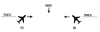
EXAMPLE-
In FIG 4-1-1 traffic information would be issued to
the pilot of aircraft "A" as 12 o'clock. The actual
position of the traffic as seen by the pilot of
aircraft "A" would be 2 o'clock. Traffic information
issued to aircraft "B" would also be given as 12
o'clock, but in this case, the pilot of "B" would see
the traffic at 10 o'clock.
FIG 4-1-2
Induced Error in
Position of Traffic
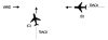
EXAMPLE-
In FIG 4-1-2 traffic information would be issued to
the pilot of aircraft "C" as 2 o'clock. The actual
position of the traffic as seen by the pilot of
aircraft "C" would be 3 o'clock. Traffic information
issued to aircraft "D" would be at an 11 o'clock
position. Since it is not necessary for the pilot of
aircraft "D" to apply wind correction (crab) to remain
on track, the actual position of the traffic issued
would be correct. Since the radar controller can only
observe aircraft track (course) on the radar display,
traffic advisories are issued accordingly, and pilots
should give due consideration to this fact when
looking for reported traffic.
4-1-15. Safety Alert
A safety alert will be
issued to pilots of aircraft being controlled by ATC if
the controller is aware the aircraft is at an altitude
which, in the controller's judgment, places the aircraft
in unsafe proximity to terrain, obstructions or other
aircraft. The provision of this service is contingent
upon the capability of the controller to have an
awareness of a situation involving unsafe proximity to
terrain, obstructions and uncontrolled aircraft. The
issuance of a safety alert cannot be mandated, but it
can be expected on a reasonable, though intermittent
basis. Once the alert is issued, it is solely the
pilot's prerogative to determine what course of action,
if any, to take. This procedure is intended for use in
time critical situations where aircraft safety is in
question. Noncritical situations should be handled via
the normal traffic alert procedures.
a. Terrain or
Obstruction Alert
1.
Controllers will immediately issue an
alert to the pilot of an aircraft under their
control when they recognize that the aircraft is at
an altitude which, in their judgment, may be in an
unsafe proximity to terrain/obstructions. The
primary method of detecting unsafe proximity is
through Mode C automatic altitude reports.
EXAMPLE-
Low altitude alert, check your altitude immediately.
The, as appropriate, MEA/MVA/MOCA in your area is
(altitude) or, if past the final approach fix (nonprecision
approach) or the outer marker or fix used in lieu of
the outer marker (precision approach), the, as
appropriate, MDA/DH (if known) is (altitude).
2.
Terminal ARTS IIA, III, AND IIIA
facilities have an automated function which, if
operating, alerts controllers when a tracked Mode C
equipped aircraft under their control is below or is
predicted to be below a predetermined minimum safe
altitude. This function, called Minimum Safe
Altitude Warning (MSAW), is designed solely as a
controller aid in detecting potentially unsafe
aircraft proximity to terrain/obstructions. The ARTS
IIA, III, and IIIA facility will, when MSAW is
operating, provide MSAW monitoring for all aircraft
with an operating Mode C altitude encoding
transponder that are tracked by the system and are:
(a)
Operating on an IFR flight plan; or
(b)
Operating VFR and have requested
MSAW monitoring.
3.
Terminal AN/TPX-42A (number beacon
decoder system) facilities have an automated
function called Low Altitude Alert System (LAAS).
Although not as sophisticated as MSAW, LAAS alerts
the controller when a Mode C transponder equipped
aircraft operating on an IFR flight plan is below a
predetermined minimum safe altitude.
NOTE-
Pilots operating VFR may request MSAW or LAAS
monitoring if their aircraft are equipped with Mode
C transponders.
EXAMPLE-
Apache Three Three Papa request MSAW/LAAS.
b. Aircraft Conflict
Alert.
1.
Controllers will immediately issue an
alert to the pilot of an aircraft under their
control if they are aware of another aircraft which
is not under their control, at an altitude which, in
the controller's judgment, places both aircraft in
unsafe proximity to each other. With the alert, when
feasible, the controller will offer the pilot the
position of the traffic if time permits and an
alternate course(s) of action. Any alternate
course(s) of action the controller may recommend to
the pilot will be predicated only on other traffic
being worked by the controller.
EXAMPLE-
American Three, traffic alert, (position of traffic,
if time permits), advise you turn right/left heading
(degrees) and/or climb/descend to (altitude)
immediately.
4-1-16. Radar Assistance to
VFR Aircraft
a.
Radar equipped FAA ATC facilities
provide radar assistance and navigation service
(vectors) to VFR aircraft provided the aircraft can
communicate with the facility, are within radar
coverage, and can be radar identified.
b.
Pilots should clearly understand that
authorization to proceed in accordance with such radar
navigational assistance does not constitute
authorization for the pilot to violate CFR's. In
effect, assistance provided is on the basis that
navigational guidance information issued is advisory
in nature and the job of flying the aircraft safely,
remains with the pilot.
c.
In many cases, controllers will be
unable to determine if flight into instrument
conditions will result from their instructions. To
avoid possible hazards resulting from being vectored
into IFR conditions, pilots should keep controllers
advised of the weather conditions in which they are
operating and along the course ahead.
d.
Radar navigation assistance (vectors)
may be initiated by the controller when one of the
following conditions exist:
1.
The controller suggests the vector
and the pilot concurs.
2.
A special program has been
established and vectoring service has been
advertised.
3.
In the controller's judgment the
vector is necessary for air safety.
e.
Radar navigation assistance (vectors)
and other radar derived information may be provided in
response to pilot requests. Many factors, such as
limitations of radar, volume of traffic,
communications frequency, congestion, and controller
workload could prevent the controller from providing
it. Controllers have complete discretion for
determining if they are able to provide the service in
a particular case. Their decision not to provide the
service in a particular case is not subject to
question.
4-1-17.
Terminal Radar Services for VFR Aircraft
a. Basic Radar
Service:
1.
In addition to the use of radar for
the control of IFR aircraft, all commissioned radar
facilities provide the following basic radar
services for VFR aircraft:
(a)
Safety alerts.
(b)
Traffic advisories.
(c)
Limited radar vectoring (on a
workload permitting basis).
(d)
Sequencing at locations where
procedures have been established for this purpose
and/or when covered by a Letter of Agreement.
NOTE-
When the stage services were developed, two basic
radar services (traffic advisories and limited
vectoring) were identified as "Stage I." This
definition became unnecessary and the term "Stage
I" was eliminated from use. The term "Stage II"
has been eliminated in conjunction with the
airspace reclassification, and sequencing services
to locations with local procedures and/or letters
of agreement to provide this service have been
included in basic services to VFR aircraft. These
basic services will still be provided by all
terminal radar facilities whether they include
Class B, Class C, Class D or Class E airspace.
"Stage III" services have been replaced with
"Class B" and "TRSA" service where applicable.
2.
Vectoring service may be provided
when requested by the pilot or with pilot
concurrence when suggested by ATC.
3.
Pilots of arriving aircraft should
contact approach control on the publicized frequency
and give their position, altitude, aircraft call
sign, type aircraft, radar beacon code (if
transponder equipped), destination, and request
traffic information.
4.
Approach control will issue wind and
runway, except when the pilot states "have numbers"
or this information is contained in the ATIS
broadcast and the pilot states that the current ATIS
information has been received. Traffic information
is provided on a workload permitting basis. Approach
control will specify the time or place at which the
pilot is to contact the tower on local control
frequency for further landing information. Radar
service is automatically terminated upon being
advised to contact the tower.
5.
Sequencing for VFR aircraft is
available at certain terminal locations (see
locations listed in the Airport/Facility Directory).
The purpose of the service is to adjust the flow of
arriving VFR and IFR aircraft into the traffic
pattern in a safe and orderly manner and to provide
radar traffic information to departing VFR aircraft.
Pilot participation is urged but is not mandatory.
Traffic information is provided on a workload
permitting basis. Standard radar separation between
VFR or between VFR and IFR aircraft is not provided.
(a)
Pilots of arriving VFR aircraft
should initiate radio contact on the publicized
frequency with approach control when approximately
25 miles from the airport at which sequencing
services are being provided. On initial contact by
VFR aircraft, approach control will assume that
sequencing service is requested. After radar
contact is established, the pilot may use pilot
navigation to enter the traffic pattern or,
depending on traffic conditions, approach control
may provide the pilot with routings or vectors
necessary for proper sequencing with other
participating VFR and IFR traffic en route to the
airport. When a flight is positioned behind a
preceding aircraft and the pilot reports having
that aircraft in sight, the pilot will be
instructed to follow the preceding aircraft. THE
ATC INSTRUCTION TO FOLLOW THE PRECEDING AIRCRAFT
DOES NOT AUTHORIZE THE PILOT TO
COMPLY WITH ANY ATC CLEARANCE OR
INSTRUCTION ISSUED TO THE PRECEDING AIRCRAFT. If
other "nonparticipating" or "local" aircraft are
in the traffic pattern, the tower will issue a
landing sequence. Radar service will be continued
to the runway. If an arriving aircraft does not
want the service, the pilot should state "NEGATIVE
RADAR SERVICE" or make a similar comment, on
initial contact with approach control.
(b)
Pilots of departing VFR aircraft
are encouraged to request radar traffic
information by notifying ground control on initial
contact with their request and proposed direction
of flight.
EXAMPLE-
Xray ground control, November One Eight Six,
Cessna One Seventy Two, ready to taxi, VFR
southbound at 2,500, have information bravo and
request radar traffic information.
NOTE-
Following takeoff, the tower will advise when to
contact departure control.
(c)
Pilots of aircraft transiting the
area and in radar contact/communication with
approach control will receive traffic information
on a controller workload permitting basis. Pilots
of such aircraft should give their position,
altitude, aircraft call sign, aircraft type, radar
beacon code (if transponder equipped),
destination, and/or route of flight.
b. TRSA Service
(Radar Sequencing and Separation Service for VFR
Aircraft in a TRSA).
1.
This service has been implemented at
certain terminal locations. The service is
advertised in the Airport/Facility Directory. The
purpose of this service is to provide separation
between all participating VFR aircraft and all IFR
aircraft operating within the airspace defined as
the Terminal Radar Service Area (TRSA). Pilot
participation is urged but is not mandatory.
2.
If any aircraft does not want the
service, the pilot should state "NEGATIVE TRSA
SERVICE" or make a similar comment, on initial
contact with approach control or ground control, as
appropriate.
3.
TRSA's are depicted on sectional
aeronautical charts and listed in the
Airport/Facility Directory.
4.
While operating within a TRSA, pilots
are provided TRSA service and separation as
prescribed in this paragraph. In the event of a
radar outage, separation and sequencing of VFR
aircraft will be suspended as this service is
dependent on radar. The pilot will be advised that
the service is not available and issued wind, runway
information, and the time or place to contact the
tower. Traffic information will be provided on a
workload permitting basis.
5.
Visual separation is used when
prevailing conditions permit and it will be applied
as follows:
(a)
When a VFR flight is positioned
behind a preceding aircraft and the pilot reports
having that aircraft in sight, the pilot will be
instructed by ATC to follow the preceding
aircraft. Radar service will be continued to the
runway. THE ATC INSTRUCTION TO FOLLOW THE
PRECEDING AIRCRAFT DOES NOT AUTHORIZE THE PILOT TO
COMPLY WITH ANY ATC CLEARANCE OR INSTRUCTION
ISSUED TO THE PRECEDING AIRCRAFT.
(b)
If other "nonparticipating" or
"local" aircraft are in the traffic pattern, the
tower will issue a landing sequence.
(c)
Departing VFR aircraft may be asked
if they can visually follow a preceding departure
out of the TRSA. The pilot will be instructed to
follow the other aircraft provided that the pilot
can maintain visual contact with that aircraft.
6.
VFR aircraft will be separated from
VFR/IFR aircraft by one of the following:
(a)
500 feet vertical separation.
(b)
Visual separation.
(c)
Target resolution (a process to
ensure that correlated radar targets do not touch)
when using broadband radar systems.
7.
Participating pilots operating VFR in
a TRSA:
(a)
Must maintain an altitude when
assigned by ATC unless the altitude assignment is
to maintain at or below a specified altitude. ATC
may assign altitudes for separation that do not
conform to 14 CFR Section 91.159. When the
altitude assignment is no longer needed for
separation or when leaving the TRSA, the
instruction will be broadcast, "RESUME APPROPRIATE
VFR ALTITUDES." Pilots must then return to an
altitude that conforms to 14 CFR Section 91.159 as
soon as practicable.
(b)
When not assigned an altitude, the
pilot should coordinate with ATC prior to any
altitude change.
8.
Within the TRSA, traffic information
on observed but unidentified targets will, to the
extent possible, be provided to all IFR and
participating VFR aircraft. The pilot will be
vectored upon request to avoid the observed traffic,
provided the aircraft to be vectored is within the
airspace under the jurisdiction of the controller.
9.
Departing aircraft should inform ATC
of their intended destination and/or route of flight
and proposed cruising altitude.
10.
ATC will normally advise
participating VFR aircraft when leaving the
geographical limits of the TRSA. Radar service is
not automatically terminated with this advisory
unless specifically stated by the controller.
c. Class C Service.
This service provides, in
addition to basic radar service, approved separation
between IFR and VFR aircraft, and sequencing of VFR
arrivals to the primary airport.
d. Class B Service.
This service provides, in
addition to basic radar service, approved separation
of aircraft based on IFR, VFR, and/or weight, and
sequencing of VFR arrivals to the primary airport(s).
e. PILOT
RESPONSIBILITY.
THESE
SERVICES ARE NOT TO BE INTERPRETED AS RELIEVING PILOTS
OF THEIR RESPONSIBILITIES TO SEE AND AVOID OTHER
TRAFFIC OPERATING IN BASIC VFR WEATHER CONDITIONS, TO
ADJUST THEIR OPERATIONS AND FLIGHT PATH AS NECESSARY
TO PRECLUDE SERIOUS WAKE ENCOUNTERS, TO MAINTAIN
APPROPRIATE TERRAIN AND OBSTRUCTION CLEARANCE, OR TO
REMAIN IN WEATHER CONDITIONS EQUAL TO OR BETTER THAN
THE MINIMUMS REQUIRED BY 14 CFR SECTION 91.155.
WHENEVER COMPLIANCE WITH AN ASSIGNED ROUTE, HEADING
AND/OR ALTITUDE IS LIKELY TO COMPROMISE PILOT
RESPONSIBILITY RESPECTING TERRAIN AND OBSTRUCTION
CLEARANCE, VORTEX EXPOSURE, AND WEATHER MINIMUMS,
APPROACH CONTROL SHOULD BE SO ADVISED AND A REVISED
CLEARANCE OR INSTRUCTION OBTAINED.
f.
ATC services for VFR aircraft
participating in terminal radar services are dependent
on ATC radar. Services for VFR aircraft are not
available during periods of a radar outage and are
limited during CENRAP operations. The pilot will be
advised when VFR services are limited or not
available.
NOTE-
Class B and Class C airspace are areas of regulated
airspace. The absence of ATC radar does not negate the
requirement of an ATC clearance to enter Class B
airspace or two way radio contact with ATC to enter
Class C airspace.
4-1-18. Tower
En Route Control (TEC)
a.
TEC is an ATC program to provide a
service to aircraft proceeding to and from
metropolitan areas. It links designated Approach
Control Areas by a network of identified routes made
up of the existing airway structure of the National
Airspace System. The FAA initiated an expanded TEC
program to include as many facilities as possible. The
program's intent is to provide an overflow resource in
the low altitude system which would enhance ATC
services. A few facilities have historically allowed
turbojets to proceed between certain city pairs, such
as Milwaukee and Chicago, via tower en route and these
locations may continue this service. However, the
expanded TEC program will be applied, generally, for
nonturbojet aircraft operating at and below 10,000
feet. The program is entirely within the approach
control airspace of multiple terminal facilities.
Essentially, it is for relatively short flights.
Participating pilots are encouraged to use TEC for
flights of two hours duration or less. If longer
flights are planned, extensive coordination may be
required within the multiple complex which could
result in unanticipated delays.
b.
Pilots requesting TEC are subject to
the same delay factor at the destination airport as
other aircraft in the ATC system. In addition,
departure and en route delays may occur depending upon
individual facility workload. When a major
metropolitan airport is incurring significant delays,
pilots in the TEC program may want to consider an
alternative airport experiencing no delay.
c.
There are no unique requirements upon
pilots to use the TEC program. Normal flight plan
filing procedures will ensure proper flight plan
processing. Pilots should include the acronym "TEC" in
the remarks section of the flight plan when requesting
tower en route control.
d.
All approach controls in the system may
not operate up to the maximum TEC altitude of 10,000
feet. IFR flight may be planned to any satellite
airport in proximity to the major primary airport via
the same routing.
4-1-19.
Transponder Operation
a. General
1.
Pilots should be aware that proper
application of transponder operating procedures will
provide both VFR and IFR aircraft with a higher
degree of safety in the environment where high-speed
closure rates are possible. Transponders
substantially increase the capability of radar to
see an aircraft and the Mode C feature enables the
controller to quickly determine where potential
traffic conflicts may exist. Even VFR pilots who are
not in contact with ATC will be afforded greater
protection from IFR aircraft and VFR aircraft which
are receiving traffic advisories. Nevertheless,
pilots should never relax their visual scanning
vigilance for other aircraft.
2.
Air Traffic Control Radar Beacon
System (ATCRBS) is similar to and compatible with
military coded radar beacon equipment. Civil Mode A
is identical to military Mode 3.
3.
Civil and military transponders
should be adjusted to the "on" or normal operating
position as late as practicable prior to takeoff and
to "off" or "standby" as soon as practicable after
completing landing roll, unless the change to
"standby" has been accomplished previously at the
request of ATC. IN ALL CASES, WHILE IN CONTROLLED
AIRSPACE EACH PILOT OPERATING AN AIRCRAFT EQUIPPED
WITH AN OPERABLE ATC TRANSPONDER MAINTAINED IN
ACCORDANCE WITH 14 CFR SECTION 91.413 SHALL OPERATE
THE TRANSPONDER, INCLUDING MODE C IF INSTALLED, ON
THE APPROPRIATE CODE OR AS ASSIGNED BY ATC. IN CLASS
G AIRSPACE, THE TRANSPONDER SHOULD BE OPERATING
WHILE AIRBORNE UNLESS OTHERWISE REQUESTED BY ATC.
4.
A pilot on an IFR flight who elects
to cancel the IFR flight plan prior to reaching
destination, should adjust the transponder according
to VFR operations.
5.
If entering a U.S. OFFSHORE AIRSPACE
AREA from outside the U.S., the pilot should advise
on first radio contact with a U.S. radar ATC
facility that such equipment is available by adding
"transponder" to the aircraft identification.
6.
It should be noted by all users of
ATC transponders that the coverage they can expect
is limited to "line of sight." Low altitude or
aircraft antenna shielding by the aircraft itself
may result in reduced range. Range can be improved
by climbing to a higher altitude. It may be possible
to minimize antenna shielding by locating the
antenna where dead spots are only noticed during
abnormal flight attitudes.
b. Transponder Code
Designation
1.
For ATC to utilize one or a
combination of the 4096 discrete codes FOUR DIGIT
CODE DESIGNATION will be used, e.g., code 2100 will
be expressed as TWO ONE ZERO ZERO. Due to the
operational characteristics of the rapidly expanding
automated ATC system, THE LAST TWO DIGITS OF THE
SELECTED TRANSPONDER CODE SHOULD ALWAYS READ "00"
UNLESS SPECIFICALLY REQUESTED BY ATC TO BE
OTHERWISE.
c. Automatic
Altitude Reporting (Mode C)
1.
Some transponders are equipped with a
Mode C automatic altitude reporting capability. This
system converts aircraft altitude in 100 foot
increments to coded digital information which is
transmitted together with Mode C framing pulses to
the interrogating radar facility. The manner in
which transponder panels are designed differs,
therefore, a pilot should be thoroughly familiar
with the operation of the transponder so that ATC
may realize its full capabilities.
2.
Adjust transponder to reply on the
Mode A/3 code specified by ATC and, if equipped, to
reply on Mode C with altitude reporting capability
activated unless deactivation is directed by ATC or
unless the installed aircraft equipment has not been
tested and calibrated as required by 14 CFR Section
91.217. If deactivation is required by ATC, turn off
the altitude reporting feature of your transponder.
An instruction by ATC to "STOP ALTITUDE SQUAWK,
ALTITUDE DIFFERS (number of feet) FEET," may be an
indication that your transponder is transmitting
incorrect altitude information or that you have an
incorrect altimeter setting. While an incorrect
altimeter setting has no effect on the Mode C
altitude information transmitted by your transponder
(transponders are preset at 29.92), it would cause
you to fly at an actual altitude different from your
assigned altitude. When a controller indicates that
an altitude readout is invalid, the pilot should
initiate a check to verify that the aircraft
altimeter is set correctly.
3.
Pilots of aircraft with operating
Mode C altitude reporting transponders should report
exact altitude or flight level to the nearest
hundred foot increment when establishing initial
contact with an ATC facility. Exact altitude or
flight level reports on initial contact provide ATC
with information that is required prior to using
Mode C altitude information for separation purposes.
This will significantly reduce altitude verification
requests.
d. Transponder IDENT
Feature
1.
The transponder shall be operated
only as specified by ATC. Activate the "IDENT"
feature only upon request of the ATC controller.
e. Code Changes
1.
When making routine code changes,
pilots should avoid inadvertent selection of Codes
7500, 7600 or 7700 thereby causing momentary false
alarms at automated ground facilities. For example,
when switching from Code 2700 to Code 7200, switch
first to 2200 then to 7200, NOT to 7700 and then
7200. This procedure applies to nondiscrete Code
7500 and all discrete codes in the 7600 and 7700
series (i.e. 7600-7677, 7700-7777) which will
trigger special indicators in automated facilities.
Only nondiscrete Code 7500 will be decoded as the
hijack code.
2.
Under no circumstances should a pilot
of a civil aircraft operate the transponder on Code
7777. This code is reserved for military interceptor
operations.
3.
Military pilots operating VFR or IFR
within restricted/warning areas should adjust their
transponders to Code 4000 unless another code has
been assigned by ATC.
f. Mode C
Transponder Requirements
1.
Specific details concerning
requirements to carry and operate Mode C
transponders, as well as exceptions and ATC
authorized deviations from the requirements are
found in 14 CFR Section 91.215 and 14 CFR Section
99.12.
2.
In general, the CFR's require
aircraft to be equipped with Mode C transponders
when operating:
(a)
At or above 10,000 feet MSL over
the 48 contiguous states or the District of
Columbia, excluding that airspace below 2,500 feet
AGL;
(b)
Within 30 miles of a Class B
airspace primary airport, below 10,000 feet MSL.
Balloons, gliders, and aircraft not equipped with
an engine driven electrical system are excepted
from the above requirements when operating below
the floor of Class A airspace and/or; outside of a
Class B airspace and below the ceiling of the
Class B airspace (or 10,000 feet MSL, whichever is
lower);
(c)
Within and above all
Class C airspace, up to 10,000 feet MSL;
(d)
Within 10 miles of certain
designated airports, excluding that airspace which
is both outside the Class D surface area and below
1,200 feet AGL. Balloons, gliders and aircraft not
equipped with an engine driven electrical system
are excepted from this requirement.
3.
14 CFR Section 99.12 requires all
aircraft flying into, within, or across the
contiguous U.S. ADIZ be equipped with a Mode C or
Mode S transponder. Balloons, gliders and aircraft
not equipped with an engine driven electrical system
are excepted from this requirement.
4.
Pilots shall ensure that their
aircraft transponder is operating on an appropriate
ATC assigned VFR/IFR code and Mode C when operating
in such airspace. If in doubt about the operational
status of either feature of your transponder while
airborne, contact the nearest ATC facility or FSS
and they will advise you what facility you should
contact for determining the status of your
equipment.
5.
In-flight requests for "immediate"
deviation from the transponder requirement may be
approved by controllers only when the flight will
continue IFR or when weather conditions prevent VFR
descent and continued VFR flight in airspace not
affected by the CFR's. All other requests for
deviation should be made by contacting the nearest
Flight Service or Air Traffic facility in person or
by telephone. The nearest ARTCC will normally be the
controlling agency and is responsible for
coordinating requests involving deviations in other
ARTCC areas.
g. Transponder
Operation Under Visual Flight Rules (VFR)
1.
Unless otherwise instructed by an ATC
facility, adjust transponder to reply on Mode 3/A
Code 1200 regardless of altitude.
2.
Adjust transponder to reply on Mode
C, with altitude reporting capability activated
if the aircraft is so equipped, unless deactivation
is directed by ATC or unless the installed equipment
has not been tested and calibrated as required by 14
CFR Section 91.217. If deactivation is required and
your transponder is so designed, turn off the
altitude reporting switch and continue to transmit
Mode C framing pulses. If this capability does not
exist, turn off Mode C.
h. Radar Beacon
Phraseology
Air traffic
controllers, both civil and military, will use the
following phraseology when referring to operation of
the Air Traffic Control Radar Beacon System (ATCRBS).
Instructions by ATC refer only to Mode A/3 or Mode C
operation and do not affect the operation of the
transponder on other Mode's.
1. SQUAWK
(number).
Operate
radar beacon transponder on designated code in Mode
A/3.
2. IDENT.
Engage the "IDENT" feature
(military I/P) of the transponder.
3. SQUAWK (number)
and IDENT.
Operate
transponder on specified code in Mode A/3 and engage
the "IDENT" (military I/P) feature.
4. SQUAWK STANDBY.
Switch transponder to
standby position.
5. SQUAWK
LOW/NORMAL.
Operate
transponder on low or normal sensitivity as
specified. Transponder is operated in "NORMAL"
position unless ATC specifies "LOW" ("ON" is used
instead of "NORMAL" as a master control label on
some types of transponders.)
6. SQUAWK
ALTITUDE.
Activate
Mode C with automatic altitude reporting.
7. STOP ALTITUDE
SQUAWK.
Turn off
altitude reporting switch and continue transmitting
Mode C framing pulses. If your equipment does not
have this capability, turn off Mode C.
8. STOP SQUAWK
(mode in use).
Switch off specified mode. (Used for military
aircraft when the controller is unaware of military
service requirements for the aircraft to continue
operation on another Mode.)
9. STOP SQUAWK.
Switch off
transponder.
10. SQUAWK MAYDAY.
Operate transponder in
the emergency position (Mode A Code 7700 for civil
transponder. Mode 3 Code 7700 and emergency feature
for military transponder.)
11. SQUAWK VFR.
Operate radar beacon
transponder on Code 1200 in the Mode A/3, or other
appropriate VFR code.
FIG 4-1-3
Hazardous Area
Reporting Service
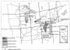
4-1-20. Hazardous Area
Reporting Service
a.
Selected FSS's provide flight
monitoring where regularly traveled VFR routes cross
large bodies of water, swamps, and mountains. This
service is provided for the purpose of expeditiously
alerting Search and Rescue facilities when required.
(See FIG 4-1-3.)
1.
When requesting the service either in
person, by telephone or by radio, pilots should be
prepared to give the following information: type of
aircraft, altitude, indicated airspeed, present
position, route of flight, heading.
2.
Radio contacts are desired at least
every 10 minutes. If contact is lost for more than
15 minutes, Search and Rescue will be alerted.
Pilots are responsible for canceling their request
for service when they are outside the service area
boundary. Pilots experiencing two-way radio failure
are expected to land as soon as practicable and
cancel their request for the service. FIG 4-1-3
depicts the areas and the FSS facilities involved in
this program.
b. Long Island Sound
Reporting Service.
The New York and
Bridgeport AFSS's provide Long Island Sound Reporting
service on request for aircraft traversing Long Island
Sound.
1.
When requesting the service, pilots
should ask for SOUND REPORTING SERVICE and should be
prepared to provide the following appropriate
information:
(a)
Type and color of aircraft;
(b)
The specific route and altitude
across the sound including the shore crossing
point;
(c)
The overwater crossing time;
(d)
Number of persons on board; and
(e)
True air speed.
2.
Radio contacts are desired at least
every 10 minutes; however, for flights of shorter
duration a midsound report is requested. If contact
is lost for more than 15 minutes Search and Rescue
will be alerted. Pilots are responsible for
canceling their request for the Long Island Sound
Reporting Service when outside the service area
boundary. Aircraft experiencing radio failure will
be expected to land as soon as practicable and
cancel their request for the service.
3. Communications.
Primary communications -
pilots are to transmit on 122.1 MHz and listen on
one of the following VOR frequencies:
(a) New York
AFSS Controls:
(1)
Hampton RCO (FSS transmits
and receives on 122.6 MHz).
(2)
Calverton VORTAC (FSS
transmits on 117.2 and receives on standard FSS
frequencies).
(3)
Kennedy VORTAC (FSS transmits
on 115.9 and receives on 122.1 MHz).
(b) Bridgeport
AFSS Controls:
(1)
Madison VORTAC (FSS transmits
on 110.4 and receives on 122.15 MHz).
(2)
Groton VOR (FSS transmits on
110.85 and receives on 122.15 MHz).
(3)
Bridgeport VOR (FSS transmits
on 108.8 and receives on 122.1 MHz).
c. Block Island
Reporting Service.
Within the Long Island
Reporting Service, the New York FSS also provides an
additional service for aircraft operating between
Montauk Point and Block Island. When requesting this
service, pilots should ask for BLOCK ISLAND REPORTING
SERVICE and should be prepared to provide the same
flight information as required for the Long Island
Sound Reporting Service.
1.
A minimum of three position reports
are mandatory for this service; these are:
(a)
Reporting leaving either Montauk
Point or Block Island.
(b)
Midway report.
(c)
Report when over either Montauk
Point or Block Island. At this time, the overwater
service is cancelled.
2. Communications.
Pilots are to transmit
and receive on 122.6 MHz.
NOTE-
Pilots are advised that 122.6 MHz is a remote
receiver located at the Hampton VORTAC site and
designed to provide radio coverage between Hampton
and Block Island. Flights proceeding beyond Block
Island may contact the Bridgeport AFSS by
transmitting on 122.1 MHz and listening on Groton
VOR (TMU) frequency 111.8 MHz.
d. Cape Cod and
Islands Radar Overwater Flight Following.
In addition to normal
VFR radar advisory services, traffic permitting, Cape
Approach Control provides a radar overwater flight
following service for aircraft traversing the Cape Cod
and adjacent Island area. Pilots desiring this service
may contact Cape RAPCON on 118.2 MHz.
1.
Pilots requesting this service should
be prepared to give the following information:
(a)
Type and color of aircraft;
(b)
Altitude;
(c)
Position and heading;
(d)
Route of flight; and
(e)
True airspeed.
2.
For best radar coverage, pilots are
encouraged to fly at 1,500 feet MSL or above.
3.
Pilots are responsible for canceling
their request for overwater flight following when
they are over the mainland and/or outside the
service area boundary.
e. Lake Reporting
Service.
Cleveland and Lansing
AFSS's provide Lake Reporting Service on request for
aircraft traversing the western half of Lake Erie;
Green Bay, Kankakee, Lansing, and Terre Haute AFSS's
provide Lake Reporting Service on request for aircraft
traversing Lake Michigan.
1.
When requesting the service, pilots
should ask for LAKE REPORTING SERVICE.
2.
Pilots not on a VFR flight
plan should be prepared to provide all information
that is normally provided for a complete VFR flight
plan.
3.
Pilots already on a VFR flight plan
should be prepared to provide the following
information:
(a)
Aircraft or flight identification.
(b)
Type of aircraft.
(c)
Near-shore crossing point or last
fix before crossing.
(d)
Proposed time over near-shore
crossing point or last fix before crossing.
(e)
Proposed altitude.
(f)
Proposed route of flight.
(g)
Estimated time over water.
(h)
Next landing point.
(i)
AFSS/FSS having complete VFR flight
plan information.
4.
Radio contacts must not exceed 10
minutes when pilots fly at an altitude that affords
continuous communications. If radio contact is lost
for more than 15 minutes (5 minutes after a
scheduled reporting time), Search and Rescue (SAR)
will be alerted.
5.
The estimated time for crossing the
far shore will be the scheduled reporting time for
aircraft that fly at an altitude that does not
afford continuous communication coverage while
crossing the lake. If radio contact is not
established within 5 minutes of that time, SAR will
be alerted.
6.
Pilots are responsible for cancelling
their request for Lake Reporting Service when
outside the service area boundary. Aircraft
experiencing radio failure will be expected to land
as soon as practicable and cancel their Lake
Reporting Service flight plan.
7. Communications.
Primary communications -
Pilots should communicate with the following
facilities on the indicated frequencies:
(a) Cleveland
AFSS Controls:
(1)
Cleveland RCO (FSS transmits
and receives on 122.35 or 122.55 MHz).
(2)
Sandusky VOR (FSS transmits
on 109.2 and receives on 122.1 MHz).
(b) Green Bay
AFSS Controls:
(1)
Escanaba VORTAC (FSS
transmits on 110.8 and receives on 122.1 MHz).
(2)
Green Bay RCO (FSS transmits
and receives on 122.55 MHz).
(3)
Manistique RCO (FSS transmits
and receives on 122.25 MHz).
(4)
Manitowoc VOR (FSS transmits
on 111.0 and receives on 122.1 MHz).
(5)
Menominee VOR (FSS transmits
on 109.6 and receives on 122.1 MHz).
(6)
Milwaukee RCO (FSS transmits
and receives on 122.65 MHz).
(7)
Falls VOR (FSS transmits on
110.0 and receives on 122.1 MHz).
(c) Kankakee
AFSS Controls:
(1)
Northbrook VORTAC (FSS
transmits on 113.0 and receives on 122.1 MHz).
(2)
Chicago Heights VORTAC (FSS
transmits on 114.2 and receives on 122.1 MHz).
(3)
Meigs RCO (FSS transmits and
receives on 122.15 MHz).
(d) Lansing AFSS
Controls:
(1) Lake Erie.
Detroit City RCO (FSS
transmits and receives on 122.55 MHz).
(2) Lake
Michigan:
[a]
Keeler VORTAC (FSS
transmits on 116.6 and receives on 122.1 MHz).
[b]
Ludington RCO (FSS
transmits and receives on 122.45 MHz).
[c]
Manistee VORTAC (FSS
transmits on 111.4 and receives on 122.1 MHz).
[d]
Muskegon RCO (FSS transmits
and receives on 122.5 MHz).
[e]
Pellston RCO (FSS transmits
and receives on 122.3 MHz).
[f]
Pullman VORTAC (FSS
transmits on 112.1 and receives on 122.1 MHz).
[g]
Traverse City RCO (FSS
transmits and receives on 122.65 MHz).
(e) Terre Haute
AFSS Controls.
South
Bend RCO's (FSS transmits and receives on
123.65/primary and 122.6/secondary MHz).
f. Everglades
Reporting Service.
This service is offered
by Miami Automated International Flight Service
Station (MIA AIFSS), in extreme southern Florida. The
service is provided to aircraft crossing the Florida
Everglades, between Lee County (Ft. Myers, FL) VORTAC
(RSW) on the northwest side, and Dolphin (Miami, FL)
VOR (DHP) on the southeast side.
1.
The pilot must request the service
from Miami AIFSS.
2.
MIA AIFSS frequency information,
122.2, 122.3, and 122.65.
3.
The pilot must file a VFR flight plan
with the remark: ERS.
4.
The pilot must maintain 2000 feet of
altitude.
5.
The pilot must make position reports
every ten (10) minutes. SAR begins fifteen (15)
minutes after position report is not made on time.
6.
The pilot is expected to land as soon
as is practical, in the event of two-way radio
failure, and advise MIA AIFSS that the service is
terminated.
7.
The pilot must notify Miami AIFSS
when the flight plan is cancelled or the service is
suspended.
4-1-21. Airport
Reservations Operations and Procedures
a.
FAA operates the Computerized Voice
Reservation System (CVRS) which is used to make
arrival and/or departure reservations at airports
designated by 14 CFR Part 93 Subpart K as High Density
Traffic Airports (HDTA). The system may also be used
to make arrival and/or departure reservations at
airports which are part of a Special Traffic
Management Program (STMP). Some STMP's may require
users to contact the controlling ARTCC to make
reservations, while others will use the CVRS to make
reservations. Pilots should check current Notices to
Airmen (NOTAM's) to determine airports included in a
special traffic management program and reservations
procedures.
b. High Density
Traffic Airports (HDTA).
1.
The FAA, by 14 CFR Part 93, Subpart
K, as amended, has designated the John F. Kennedy
International Airport (JFK), LaGuardia (LGA),
Chicago O'Hare International (ORD), Ronald Reagan
Washington National Airport (DCA), and Newark
International (EWR) Airports as high density
airports and has prescribed air traffic rules and
requirements for operating aircraft to and from
these airports. (The quota for EWR has been
suspended indefinitely.) Reservations for JFK are
required between 3:00 p.m. and 7:59 p.m. local time.
Reservations at ORD are required between 6:45 a.m.
and 9:15 p.m. local time. Reservations for LGA and
DCA are required between 6:00 a.m. and 11:59 p.m.
local time. Helicopter operations are excluded from
the requirement for a reservation.
NOTE-
Time periods for ORD are in 30-minute increments.
2.
The FAA has established an Airport
Reservations Office (ARO) to receive and process all
Instrument Flight Rules (IFR) requests for
operations at the designated HDTA's. This office
monitors operation of the high density rule and
allots reservations on a "first-come-first-served"
basis determined by the time the request is received
at the reservation office. Standby lists are not
maintained. The ARO utilizes the CVRS to make all
reservations. Users may access the computer system
using a touch tone telephone, rotary dial telephone,
or a personal computer equipped with a modem.
Requests for IFR reservations will be accepted
starting 48 hours prior to the proposed time of
operation at the affected airport. For example, a
request for an 11:00 a.m. reservation on a Thursday
will be accepted beginning at 11:00 a.m. on the
preceding Tuesday. An exception to the 48 hour
limitation is made for weekends to recognize normal
business hours. Consequently, a reservation request
for an IFR operation on Monday would be accepted on
the previous Thursday, starting at the proposed hour
of operation. Similarly, requests for IFR operations
on Tuesday would be accepted on the previous Friday,
starting at the proposed hour of operation. For
example, a request for an 11:00 a.m. reservation on
Tuesday would be accepted beginning at 11:00 a.m. on
Friday. Another exception to the 48 hour time limit
is made for users who make both an arrival and
departure reservation provided they both fall on the
same calendar day and they are both made during the
same phone call. For example, a reservation request
for an 11:00 a.m. arrival on Friday and a 4:00 p.m.
departure on Friday may be made beginning at 11:00
a.m. Wednesday.
3.
A maximum of two transactions per
phone call will be accepted.
4.
The ARO will not provide scheduling
according to planned departure/arrival time.
Assignments will be made on an hourly or 30-minute
basis, e.g., an approved reservation for 1300 covers
an operation any time between 1300 and 1359 and an
approved reservation for 0845 at O'Hare covers an
operation between 0845 and 0914.
5.
An approved reservation does not
constitute a warranty against traffic delays nor
does it guarantee arrival and/or departure within
such allocated hours. Also, a reservation does not
constitute an ATC clearance.
6.
The filing of a request for an IFR
reservation does not constitute the filing of an IFR
flight plan as required by regulation. The IFR
flight plan should be filed only after the
reservation is obtained and should be filed through
normal channels. The ARO is not equipped to accept
or process IFR flight plans.
c. IFR Reservations.
1.
If operating IFR, an IFR reservation
is required prior to takeoff for any operation to or
from a high density airport. Users may obtain IFR
reservations in either of two ways. They may file
their request with the nearest Flight Service
Station (FSS) by any available means or call the
ARO's interactive computer system via touch-tone
telephone, rotary dial telephone, or personal
computer modem.
The telephone numbers
for the ARO computer are: Using touch-tone or rotary
phone: 1-800-875-9694. For Personal Computer and
Modem: 1-800-875-9759.
Users may contact the
ARO at 703-904-4452 if they have a problem making a
reservation or have a question concerning the HDTA
regulations. (Being unable to make a reservation due
to the fact that all the slots have been allocated
is not considered as having a problem making a
reservation).
2.
When filing a request for an IFR
reservation, the pilot should be prepared to provide
the following information:
(a)
Name(s) of high density traffic
airport(s) for which the pilot wishes
reservation(s).
(b)
Date(s) and hour(s) (UTC) of
proposed operation(s).
(c) Aircraft
identification/tail number(s).
3.
Should the requested time not be
available, the user will be offered the closest time
before or after the requested time. If an alternate
time is accepted, this will be considered as an
assigned allocation unless subsequently cancelled by
the user.
4.
Users are encouraged to advise the
ARO whenever they need to change their reservation
or to cancel their IFR reservation when it is known
that the reservation will not be used. For other
than scheduled air carriers/commuters, a
cancellation should be made directly to the ARO
computer system or an FSS.
5.
The following information should be
available when cancelling a reservation:
(a)
Aircraft identification/tail
number.
(b)
Airport for which reservation was
made.
(c)
Date and Time (UTC) of reservation.
(d)
Reservation number.
6.
To ensure retention of a reservation,
a pilot holding an IFR arrival reservation must
retain IFR status until in contact with the terminal
ATC facility.
7.
Reservations are required when filing
one of the HDTA's as an alternate airport. Pilots
are encouraged to file airports other than the high
density as alternate airports.
d. Additional IFR
Reservations.
1.
If favorable conditions in the system
and at the HDTA indicate a significant delay is not
likely in the short term, the ARO may coordinate
with the HDTA tower to determine that additional IFR
reservations may be accommodated for a specific time
period. This is an additional IFR reservation as
described in 14 CFR Part 93. If additional IFR
reservations can be accommodated, they are
administered by the ARO under the procedures
described above.
2.
An operator of an IFR unscheduled
operation may take off or land an aircraft without
regard to the maximum allocation if a reservation is
obtained from ATC in accordance with the procedures
above. A reservation is granted for an additional
IFR operation only if it can be accommodated by ATC
without significant additional delay to operations
already allocated. The granting of an additional IFR
reservation is contingent upon dynamic, short-term
traffic and weather conditions. Generally,
availability of additionals will not be known more
than 8 hours in advance of the current time. If
available, IFR additionals will be granted on a
first-come-first- served basis.
3.
An operator who has been unable to
obtain a reservation under the normal 48 hour in
advance procedure may find they are able to obtain a
reservation on the scheduled day of operation when
additionals can be authorized.
e. Visual Flight
Rules (VFR) Reservations.
1.
The operator of a VFR unscheduled
operation may take off or land an aircraft under VFR
at an HDTA if a departure or arrival reservation is
obtained from the FAA ATC facility serving the HDTA.
2.
Under 14 CFR Part 93, a VFR operation
is considered to be an additional operation. VFR
additional operations may be granted by ATC if they
can be accommodated without significant delay to
operations already allocated. In addition, the
reported ceiling at the HDTA must be at least 1,000
feet and the reported ground visibility at least 3
miles.
3.
Each HDTA lies within Class B
airspace. A clearance from ATC to enter the airspace
or depart the airport under VFR constitutes an
approval for a VFR additional reservation.
4.
Any time an HDTA is not authorizing
VFR operations, a NOTAM to that effect will be
issued by the controlling ATC facility and a
recording placed on the Automated Terminal
Information Service. This information can be
obtained from any FSS or by referring to the HDTA
teletype weather report. The code "VNA" at the end
of the weather report indicates VFR arrival
reservations are not authorized. The indication will
not be made when IFR weather conditions exist.
5.
The requirements for obtaining
reservations pursuant to 14 CFR Part 93, Subpart K,
are mandatory. Failure to operate in accordance with
the CFR's may be grounds for enforcement action.
f. Special Traffic
Management Programs (STMP).
1.
Special procedures may be established
when a location requires special traffic handling to
accommodate above normal traffic demand (e.g., the
Indianapolis 500, Super Bowl, etc.) or reduced
airport capacity (e.g., airport runway/taxiway
closures for airport construction). The special
procedures may remain in effect until the problem
has been resolved or until local traffic management
procedures can handle the situation and a need for
special handling no longer exists.
2.
There will be two methods available
for obtaining slot reservations at the ATCSCC: the
web interface and the touch-tone interface. If these
methods are used, a NOTAM will be issued relaying
the web site address and toll-free telephone number.
Be sure to check current NOTAM's to determine: what
airports are included in the STMP; the dates and
times reservations are required; the time limits for
reservation requests; the point of contact for
reservations; and any other instructions.
g. Making HDTA
Reservations using the CVRS.
1. Computer Modem
Users.
A Personal
Computer (PC) may be used to make reservations on
the CVRS. Equipment required is a computer with a
modem capable of a 300 to 9600 baud rate and a
communications software program. There are several
communications software programs available from many
computer stores. The type program required is one
which is used to connect with a Bulletin Board
System (BBS). The CVRS modem data is transmitted
using No Parity, 8 data bits, and 1 stop bit
(N,8,1). Be sure your computer software is set to
these parameters.
2.
When your computer connects with CVRS,
you will be presented with a screen that will ask
you to log on. If this is the first time you have
logged onto the CVRS, you will be asked for your
name, the city you are calling from, and a password.
(Be sure to record your password for future use).
CVRS uses your name and password to save your
computer "set-up" so that the next time you call you
will have the same display. After you have logged
on, every thing you need to do involving a
reservation is menu driven. There are also several
files you can download which explain CVRS operations
in greater detail.
3. Telephone
users.
When using
the telephone to make a reservation, you are
prompted for input of information about what you
wish to do. All input is accomplished using the
keypad or rotary dial on the telephone. The only
problem with a telephone is that most keys have a
letter and number associated with them. When the
system asks for a date or time, it is expecting an
input of numbers. A problem arises when entering a
tail number. The system does not detect if you are
entering a letter (alpha character) or a number.
Therefore, when entering a tail number two keys are
used to represent each letter or number. When
entering a number, precede the number you wish by
the number 0 (zero) i.e. 01, 02, 03, 04, ... If you
wish to enter a letter, first press the key on which
the letter appears and then press 1, 2, or 3,
depending upon whether the letter you desire is the
first, second, or third letter on that key. For
example to enter the letter "N" first press the "6"
key because "N" is on that key, then press the "2"
key because the letter "N" is the second letter on
the "6" key. Since there are no keys for the letters
"Q" and "Z" CVRS pretends they are on the number "1"
key. Therefore, to enter the letter "Q", press 11,
and to enter the letter "Z" press 12.
NOTE-
Users are reminded to enter the "N" character with
their tail numbers. (See TBL 4-1-4.)
TBL 4-1-4
Codes for Tail Number
Input
|
Codes for Tail
Number Input Only |
|
A-21 |
J-51 |
S-73 |
1-01 |
|
B-22 |
K-52 |
T-81 |
2-02 |
|
C-23 |
L-53 |
U-82 |
3-03 |
|
D-31 |
M-61 |
V-83 |
4-04 |
|
E-32 |
N-62 |
W-91 |
5-05 |
|
F-33 |
O-63 |
X-92 |
6-06 |
|
G-41 |
P-71 |
Y-93 |
7-07 |
|
H-42 |
Q-11 |
Z-12 |
8-08 |
|
I-43 |
R-72 |
0-00 |
9-09 |
4.
Additional helpful key entries: (See
TBL 4-1-5.)
TBL 4-1-5
Helpful Key Entries
|
# |
After entering a
tail number, depressing the "pound key" (#) twice
will indicate the end of the tail number.
|
|
*2 |
Will take the user
back to the start of the process. |
|
*3 |
Will repeat the
tail number used in a previous reservation.
|
|
*5 |
Will repeat the
previous question. |
|
*8 |
Tutorial Mode: In
the tutorial mode each prompt for input includes a
more detailed description of what is expected as
input. *8 is a toggle on/off switch. If you are in
tutorial mode and enter *8, you will return to the
normal mode. |
|
*0 |
Expert Mode: In the
expert mode each prompt for input is brief with
little or no explanation. Expert mode is also
on/off toggle. |
4-1-22. Requests for Waivers and
Authorizations from Title 14, Code of Federal
Regulations (14 CFR)
a.
Requests for a Certificate of Waiver or
Authorization (FAA Form 7711-2), or requests for
renewal of a waiver or authorization, may be accepted
by any FAA facility and will be forwarded, if
necessary, to the appropriate office having waiver
authority.
b.
The grant of a Certificate of Waiver or
Authorization from 14 CFR constitutes relief from
specific regulations, to the degree and for the period
of time specified in the certificate, and does not
waive any state law or local ordinance. Should the
proposed operations conflict with any state law or
local ordinance, or require permission of local
authorities or property owners, it is the applicant's
responsibility to resolve the matter. The holder of a
waiver is responsible for compliance with the terms of
the waiver and its provisions.
c.
A waiver may be canceled at any time by
the Administrator, the person authorized to grant the
waiver, or the representative designated to monitor a
specific operation. In such case either written notice
of cancellation, or written confirmation of a verbal
cancellation will be provided to the holder.

|