|
7-1-1.
National Weather Service Aviation Products
a.
Weather service to
aviation is a joint effort of the National
Weather Service (NWS), the Federal Aviation
Administration (FAA), the military weather
services, and other aviation oriented groups and
individuals. The NWS maintains an extensive
surface, upper air, and radar weather observing
program; a nationwide aviation weather
forecasting service; and provides limited pilot
briefing service (interpretational). The
majority of pilot weather briefings are provided
by FAA personnel at Flight Service Stations (AFSS's/FSS's).
Aviation routine weather reports (METAR) are
taken manually by NWS, FAA, contractors, or
supplemental observers. METAR reports are also
provided by Automated Weather Observing System (AWOS)
and Automated Surface Observing System (ASOS).
REFERENCE-
AIM, Weather Observing Programs, Paragraph
7-1-11.
b.
Aerodrome forecasts
are prepared by approximately 100 Weather
Forecast Offices (WFO's). These offices prepare
and distribute approximately 525 aerodrome
forecasts 4 times daily for specific airports in
the 50 States, Puerto Rico, the Caribbean and
Pacific Islands. These forecasts are valid for
24 hours and amended as required. WFO's prepare
over 300 route forecasts and 39 synopses for
Transcribed Weather Broadcasts (TWEB), and
briefing purposes. The route forecasts are
issued 3 times daily, each forecast is valid for
15 hours. A centralized aviation forecast
program originating from the Aviation Weather
Center (AWC) in Kansas City was implemented in
October 1995. In the conterminous U.S., all
Inflight Advisories Significant Meteorological
Information (SIGMET's), Convective SIGMET's, and
Airmen's Meteorological Information (AIRMET's)
and all Area Forecasts (FA's) (6 areas) are now
issued by AWC. FA's are prepared 3 times a day
in the conterminous U.S. and Alaska (4 times in
Hawaii), and amended as required. Inflight
Advisories are issued only when conditions
warrant. Winds aloft forecasts are provided for
176 locations in the 48 contiguous States and 21
locations in Alaska for flight planning
purposes. (Winds aloft forecasts for Hawaii are
prepared locally.) All the aviation weather
forecasts are given wide distribution through
the Weather Message Switching Center Replacement
(WMSCR) in Atlanta, Georgia, and Salt Lake City,
Utah.
REFERENCE-
AIM, Inflight Weather Advisories, Paragraph 7-1-5.
c.
Weather element
values may be expressed by using different
measurement systems depending on several
factors, such as whether the weather products
will be used by the general public, aviation
interests, international services, or a
combination of these users.
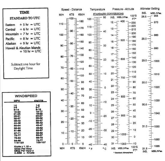
FIG 7-1-1 provides conversion tables for the
most used weather elements that will be
encountered by pilots.

7-1-2.
FAA Weather Services
a.
The FAA maintains a
nationwide network of Automated Flight Service
Stations (AFSS's/FSS's) to serve the weather
needs of pilots. In addition, NWS meteorologists
are assigned to most ARTCC's as part of the
Center Weather Service Unit (CWSU). They provide
Center Weather Advisories (CWA's) and gather
weather information to support the needs of the
FAA and other users of the system.
b. The
primary source of preflight weather briefings is
an individual briefing obtained from a briefer
at the AFSS/FSS. These briefings, which are
tailored to your specific flight, are available
24 hours a day through the use of the toll free
number (1-800-WX BRIEF). Numbers for these
services can be found in the Airport/Facility
Directory (A/FD) under "FAA and NWS Telephone
Numbers" section. They may also be listed in the
U.S. Government section of your local telephone
directory under Department of Transportation,
Federal Aviation Administration, or Department
of Commerce, National Weather Service. NWS pilot
weather briefers do not provide aeronautical
information (NOTAM's, flow control advisories,
etc.) nor do they accept flight plans.
REFERENCE-
AIM, Preflight Briefing, Paragraph 7-1-3, explains the types
of preflight briefings available and the
information contained in each.
FIG 7-1-1
Weather Elements Conversion Tables
c. Other sources of
weather information are as follows:
1.
Telephone
Information Briefing Service (TIBS) (AFSS), a
small number of Transcribed Weather Broadcast
(TWEB) locations, and telephone access to the
TWEB (TEL-TWEB) provide continuously updated
recorded weather information for short or
local flights. Separate paragraphs in this
section give additional information regarding
these services.
REFERENCE-
AIM, Telephone Information Briefing Service (TIBS),
Paragraph 7-1-7.
AIM, Transcribed Weather Broadcast (TWEB),
Paragraph 7-1-8.
2.
Weather and
aeronautical information are also available
from numerous private industry sources on an
individual or contract pay basis. Information
on how to obtain this service should be
available from local pilot organizations.
3.
The Direct User
Access Terminal System (DUATS) can be accessed
by pilots with a current medical certificate
toll-free in the 48 contiguous States via
personal computer. Pilots can receive
alpha-numeric preflight weather data and file
domestic VFR and IFR flight plans. The
following are the contract DUATS vendors:
GTE Federal Systems
15000 Conference Center Drive
Chantilly, VA 22021-3808
Computer Modem Access Number: For filing
flight plans and obtaining weather briefings:
(800) 767-9989
For customer service: (800) 345-3828
Data Transformation Corporation
108-D Greentree Road
Turnersville, NJ 08012
Computer Modem Access Number: For filing
flight plans and obtaining weather briefings:
(800) 245-3828
For customer service: (800) 243-3828
d.
Inflight weather
information is available from any FSS within
radio range. The common frequency for all AFSS's
is 122.2. Discrete frequencies for individual
stations are listed in the A/FD.
1.
Information on
In-Flight Weather broadcasts.
REFERENCE-
AIM, Inflight Weather Broadcasts, Paragraph 7-1-9.
2.
En Route Flight
Advisory Service (EFAS) is provided to serve
the nonroutine weather needs of pilots in
flight.
REFERENCE-
AIM, En Route Flight Advisory Service (EFAS),
Paragraph 7-1-4, gives
details on this service.
7-1-3.
Preflight Briefing
a.
Flight Service
Stations (AFSS's/FSS's) are the primary source
for obtaining preflight briefings and inflight
weather information. Flight Service Specialists
are qualified and certificated by the NWS as
Pilot Weather Briefers. They are not authorized
to make original forecasts, but are authorized
to translate and interpret available forecasts
and reports directly into terms describing the
weather conditions which you can expect along
your flight route and at your destination.
Available aviation weather reports, forecasts
and aviation weather charts are displayed at
each AFSS/FSS, for pilot use. Pilots should feel
free to use these self briefing displays where
available, or to ask for a briefing or
assistance from the specialist on duty. Three
basic types of preflight briefings are available
to serve your specific needs. These are:
Standard Briefing, Abbreviated Briefing, and
Outlook Briefing. You should specify to the
briefer the type of briefing you want, along
with your appropriate background information.
This will enable the briefer to tailor the
information to your intended flight. The
following paragraphs describe the types of
briefings available and the information provided
in each briefing.
REFERENCE-
AIM, Preflight Preparation, Paragraph
5-1-1, for items that are required.
b. Standard
Briefing.
You should request
a Standard Briefing any time you are planning a
flight and you have not received a previous
briefing or have not received preliminary
information through mass dissemination media;
e.g., TIBS, TWEB, etc. International data may be
inaccurate or incomplete. If you are planning a
flight outside of U.S. controlled airspace, the
briefer will advise you to check data as soon as
practical after entering foreign airspace,
unless you advise that you have the
international cautionary advisory. The briefer
will automatically provide the following
information in the sequence listed, except as
noted, when it is applicable to your proposed
flight.
1. Adverse
Conditions.
Significant
meteorological and aeronautical information
that might influence the pilot to alter the
proposed flight; e.g., hazardous weather
conditions, airport closures, air traffic
delays, etc.
2. VFR Flight Not
Recommended.
When VFR flight
is proposed and sky conditions or visibilities
are present or forecast, surface or aloft,
that in the briefer's judgment would make
flight under visual flight rules doubtful, the
briefer will describe the conditions, affected
locations, and use the phrase "VFR flight
not recommended." This recommendation is
advisory in nature. The final decision as to
whether the flight can be conducted safely
rests solely with the pilot.
3. Synopsis.
A
brief statement describing the type, location
and movement of weather systems and/or air
masses which might affect the proposed flight.
NOTE-
These first 3 elements of a briefing may be
combined in any order when the briefer
believes it will help to more clearly describe
conditions.
4. Current
Conditions.
Reported weather
conditions applicable to the flight will be
summarized from all available sources; e.g.,
METAR's/SPECI's, PIREP's, RAREP's. This
element will be omitted if the proposed time
of departure is beyond 2 hours, unless the
information is specifically requested by the
pilot.
5. En Route
Forecast.
Forecast en route
conditions for the proposed route are
summarized in logical order; i.e., departure/climbout,
en route, and descent. (Heights are MSL,
unless the contractions "AGL" or "CIG" are
denoted indicating that heights are above
ground.)
6. Destination
Forecast.
The destination
forecast for the planned ETA. Any significant
changes within 1 hour before and after the
planned arrival are included.
7. Winds Aloft.
Forecast winds aloft will be provided using
degrees of the compass. The briefer will
interpolate wind directions and speeds between
levels and stations as necessary to provide
expected conditions at planned altitudes.
(Heights are MSL.) Temperature information
will be provided on request.
8. Notices to
Airmen (NOTAM's).
(a)
Available NOTAM (D) information pertinent to
the proposed flight.
(b)
NOTAM (L) information pertinent to the
departure and/or local area, if available,
and pertinent FDC NOTAM's within
approximately 400 miles of the FSS providing
the briefing. AFSS facilities will provide
FDC NOTAM's for the entire route of flight.
NOTE-
NOTAM information may be combined with
current conditions when the briefer believes
it is logical to do so.
NOTE-
NOTAM (D) information and FDC NOTAM's which
have been published in the Notices to Airmen
Publication are not included in pilot
briefings unless a review of this
publication is specifically requested by the
pilot. For complete flight information you
are urged to review the printed NOTAM's in
the Notices to Airmen Publication and the
A/FD in addition to obtaining a briefing.
9. ATC Delays.
Any
known ATC delays and flow control advisories
which might affect the proposed flight.
10. Pilots may
obtain the following from AFSS/FSS briefers
upon request:
(a)
Information on Military Training Routes (MTR's)
and Military Operations Area (MOA's)
activity within the flight plan area and a
100 NM extension around the flight plan
area.
NOTE-
Pilots are encouraged to request updated
information from en route AFSS's.
(b)
A review of the Notices to Airmen
Publication for pertinent NOTAM's and
Special Notices.
(c)
Approximate density altitude data.
(d)
Information regarding such items as air
traffic services and rules,
customs/immigration procedures, ADIZ rules,
search and rescue, etc.
(e)
LORAN-C NOTAM's, available military NOTAM's,
and runway friction measurement value
NOTAM's.
(f)
GPS RAIM availability for 1 hour before to 1
hour after ETA or a time specified by the
pilot.
(g)
Other assistance as required.
c. Abbreviated
Briefing.
Request an
Abbreviated Briefing when you need information
to supplement mass disseminated data, update a
previous briefing, or when you need only one or
two specific items. Provide the briefer with
appropriate background information, the time you
received the previous information, and/or the
specific items needed. You should indicate the
source of the information already received so
that the briefer can limit the briefing to the
information that you have not received, and/or
appreciable changes in
meteorological/aeronautical conditions since
your previous briefing. To the extent possible,
the briefer will provide the information in the
sequence shown for a Standard Briefing. If you
request only one or two specific items, the
briefer will advise you if adverse conditions
are present or forecast. (Adverse conditions
contain both meteorological and/or aeronautical
information.) Details on these conditions will
be provided at your request. International data
may be inaccurate or incomplete. If you are
planning a flight outside of U.S. controlled
airspace, the briefer will advise you to check
data as soon as practical after entering foreign
airspace, unless you advise that you have the
international cautionary advisory.
d. Outlook
Briefing.
You should request
an Outlook Briefing whenever your proposed time
of departure is six or more hours from the time
of the briefing. The briefer will provide
available forecast data applicable to the
proposed flight. This type of briefing is
provided for planning purposes only. You should
obtain a Standard or Abbreviated Briefing prior
to departure in order to obtain such items as
adverse conditions, current conditions, updated
forecasts, winds aloft and NOTAM's, etc.
e.
When filing a
flight plan only, you will be asked if you
require the latest information on adverse
conditions pertinent to the route of flight.
f. Inflight
Briefing.
You are encouraged
to obtain your preflight briefing by telephone
or in person before departure. In those cases
where you need to obtain a preflight briefing or
an update to a previous briefing by radio, you
should contact the nearest AFSS/FSS to obtain
this information. After communications have been
established, advise the specialist of the type
briefing you require and provide appropriate
background information. You will be provided
information as specified in the above
paragraphs, depending on the type briefing
requested. In addition, the specialist will
recommend shifting to the Flight Watch frequency
when conditions along the intended route
indicate that it would be advantageous to do so.
g.
Following any
briefing, feel free to ask for any information
that you or the briefer may have missed or are
not understood. This way, the briefer is able to
present the information in a logical sequence,
and lessens the chance of important items being
overlooked.
7-1-4.
En Route Flight Advisory Service (EFAS)
a.
EFAS is a service
specifically designed to provide en route
aircraft with timely and meaningful weather
advisories pertinent to the type of flight
intended, route of flight, and altitude. In
conjunction with this service, EFAS is also a
central collection and distribution point for
pilot reported weather information. EFAS is
provided by specially trained specialists in
selected AFSS's controlling multiple Remote
Communications Outlets covering a large
geographical area and is normally available
throughout the conterminous U.S. and Puerto Rico
from 6 a.m. to 10 p.m. EFAS provides
communications capabilities for aircraft flying
at 5,000 feet above ground level to 17,500 feet
MSL on a common frequency of 122.0 MHz. Discrete
EFAS frequencies have been established to ensure
communications coverage from 18,000 through
45,000 MSL serving in each specific ARTCC area.
These discrete frequencies may be used below
18,000 feet when coverage permits reliable
communication.
NOTE-
When an EFAS outlet is located in a time zone
different from the zone in which the flight
watch control station is located, the
availability of service may be plus or minus one
hour from the normal operating hours.
b.
Contact flight
watch by using the name of the ARTCC facility
identification serving the area of your
location, followed by your aircraft
identification, and the name of the nearest VOR
to your position. The specialist needs to know
this approximate location to select the most
appropriate transmitter/receiver outlet for
communications coverage.
EXAMPLE-
Cleveland Flight Watch, Cessna One Two Three
Four Kilo, Mansfield V-O-R, over.
c.
Charts depicting
the location of the flight watch control
stations (parent facility) and the outlets they
use are contained in the A/FD. If you do not
know in which flight watch area you are flying,
initiate contact by using the words "Flight
Watch," your aircraft identification, and the
name of the nearest VOR. The facility will
respond using the name of the flight watch
facility.
EXAMPLE-
Flight Watch, Cessna One Two Three Four Kilo,
Mansfield V-O-R, over.
d.
AFSS's that provide
En Route Flight Advisory Service are listed
regionally in the A/FD's.
e.
EFAS is not
intended to be used for filing or closing flight
plans, position reporting, getting complete
preflight briefings, or obtaining random weather
reports and forecasts. En route flight
advisories are tailored to the phase of flight
that begins after climb-out and ends with
descent to land. Immediate destination weather
and terminal aerodrome forecasts will be
provided on request. Pilots requesting
information not within the scope of flight watch
will be advised of the appropriate AFSS/FSS
frequency to obtain the information. Pilot
participation is essential to the success of
EFAS by providing a continuous exchange of
information on weather, winds, turbulence,
flight visibility, icing, etc., between pilots
and flight watch specialists. Pilots are
encouraged to report good weather as well as
bad, and to confirm expected conditions as well
as unexpected to EFAS facilities.
7-1-5.
Inflight Weather Advisories
a.
The NWS issues
inflight weather advisories designated as Severe
Weather Forecast Alerts (AWW's), Convective
SIGMET's (WST's), SIGMET's (WS's), Center
Weather Advisories (CWA's), and AIRMET's (WA's).
Inflight advisories serve to notify en route
pilots of the possibility of encountering
hazardous flying conditions which may not have
been forecast at the time of the preflight
briefing. Whether or not the condition described
is potentially hazardous to a particular flight
is for the pilot and/or aircraft dispatcher in a
14 CFR Part 121 operation to evaluate on the
basis of experience and the operational limits
of the aircraft. Inflight weather advisories in
the contiguous U.S. are described and plotted
primarily using high altitude VOR's as reference
points. In Alaska and Hawaii, advisories are
described and plotted using either geographic
references or latitude/longitude coordinates.
b.
Severe Weather
Forecast Alerts (AWW's) are preliminary messages
issued in order to alert users that a Severe
Weather Bulletin (WW) is being issued. These
messages define areas of possible severe
thunderstorms or tornado activity. The messages
are unscheduled and issued as required by the
Aviation Weather Center at Kansas City,
Missouri.
1.
Each AWW is
numbered sequentially beginning January 1 of
each year.
EXAMPLE-
MKC AWW 161755
WW 279 SEVERE TSTM NY PA NJ
161830Z-170000Z
AXIS..70 STATUTE MILES EITHER SIDE OF
LINE..10W KMSS TO 20E KABE..AVIATION COORDS..60NM
EITHER SIDE/60NW KSLK - 35W KEWR..HAIL SURFACE
AND ALOFT..2 INCHES. SURFACE WIND GUSTS..65
KNOTS. MAX TOPS TO 540. MEAN WIND VECTOR
19020.
REPLACES WW 278..OH PA NY
2.
Status reports
are issued as needed on Severe Weather Watch
Bulletins to show progress of storms and to
delineate areas no longer under the threat of
severe storm activity. Cancellation bulletins
are issued when it becomes evident that no
severe weather will develop or that storms
have subsided and are no longer severe.
c.
Convective SIGMET's
(WST's) in the Conterminous U.S.: WST's concern
only thunderstorms and related phenomena
(tornadoes, heavy precipitation, hail, and high
surface winds) over the conterminous U.S. and
imply the associated occurrence of turbulence,
icing, and convective low level wind shear.
Individual WST's for each day are numbered
sequentially (00-1-99), beginning at 00Z. The
affected geographic area is contained in the
number; i.e., the first WST issued each day in
the eastern U.S. is Convective SIGMET 1E, the
second is Convective SIGMET 2E, and so forth.
WST's are issued on a scheduled basis, hourly at
55 minutes past the hour (H+55), and are valid
for two hours or until superseded by the next
hourly update. WST's are issued for any of the
following phenomena:
1.
Severe
thunderstorm due to:
(a)
Surface winds greater than or equal to 50
knots.
(b)
Hail at the surface greater than or equal to
3/4
inches in diameter.
(c)
Tornadoes.
2.
Embedded
thunderstorms.
3.
A line of
thunderstorms.
4.
Thunderstorms
greater than or equal to VIP level 4 affecting
40% or more of an area at least 3,000 square
miles.
NOTE-
Since thunderstorms are the reason for issuing
the WST, severe or greater turbulence, severe
icing, and low-level wind shear (gust fronts,
downbursts, microbursts, etc.) are implied and
will not be specified in the advisory.
d. Convective
SIGMET Bulletins.
1.
Three Convective
SIGMET bulletins, each covering a specified
geographic area, are issued. These areas are
the Eastern (E), Central (C), and Western (W)
U.S. The boundaries that separate the Eastern
from the Central and the Central from the
Western U.S. are 87 and 107 degrees West,
respectively. These bulletins are issued on a
scheduled basis, hourly at 55 minutes past the
hour (H+55), and as special bulletins on an
unscheduled basis.
2.
Each of the
Convective SIGMET bulletins will be:
(a)
Made up of one or more individually numbered
Convective SIGMET's,
(b)
Valid for two hours or until superseded by
the next hourly issuance.
(c)
The text of the bulletin consists of either
an observation and a forecast or just a
forecast.
3.
On an hourly
basis, an outlook is made for each of the
three Convective SIGMET regions. The outlook
for a particular region is appended to the
Convective SIGMET bulletin for the same
region. The convective outlook is also
appended to special Convective SIGMET's. The
outlook is reviewed each hour and revised when
necessary. The outlook is a forecast and
meteorological discussion for thunderstorm
systems that are expected to require
Convective SIGMET issuances during a time
period 2-6 hours into the future. Furthermore,
an outlook will always be made for each of the
three regions, even if it is a negative
statement.
e.
SIGMET's (WS's)
within the conterminous U.S. are issued by the
Aviation Weather Center (AWC) when the following
phenomena occur or are expected to occur:
1.
Severe or extreme
turbulence or clear air turbulence (CAT) not
associated with thunderstorms.
2.
Severe icing not
associated with thunderstorms.
3.
Duststorms,
sandstorms, or volcanic ash lowering surface
or inflight visibilities to below three miles.
4.
Volcanic
eruption.
f.
Volcanic eruption
SIGMET's are identified by an alphanumeric
designator which consists of an alphabetic
identifier and issuance number. The first time
an advisory is issued for a phenomenon
associated with a particular weather system, it
will be given the next alphabetic designator in
the series and will be numbered as the first for
that designator. Subsequent advisories will
retain the same alphabetic designator until the
phenomenon ends. In the conterminous U.S., this
means that a phenomenon that is assigned an
alphabetic designator in one area will retain
that designator as it moves within the area or
into one or more other areas. Issuances for the
same phenomenon will be sequentially numbered,
using the same alphabetic designator until the
phenomenon no longer exists. Alphabetic
designators NOVEMBER through YANKEE, except
SIERRA and TANGO are only used for SIGMET's,
while designators SIERRA, TANGO and ZULU are
used for AIRMET's.
g.
Center Weather
Advisories (CWA's).
1.
CWA's are
unscheduled inflight, flow control, air
traffic, and air crew advisory. By nature of
its short lead time, the CWA is not a flight
planning product. It is generally a Nowcast
for conditions beginning within the next two
hours. CWA's will be issued:
(a)
As a supplement to an existing SIGMET,
Convective SIGMET or AIRMET.
(b)
When an Inflight Advisory has not been
issued but observed or expected weather
conditions meet SIGMET/AIRMET criteria based
on current pilot reports and reinforced by
other sources of information about existing
meteorological conditions.
(c)
When observed or developing weather
conditions do not meet SIGMET, Convective
SIGMET, or AIRMET criteria; e.g., in terms
of intensity or area coverage, but current
pilot reports or other weather information
sources indicate that existing or
anticipated meteorological phenomena will
adversely affect the safe flow of air
traffic within the ARTCC area of
responsibility.
2.
The following
example is a CWA issued from the Kansas City,
Missouri, ARTCC. The "3" after ZKC in the
first line denotes this CWA has been issued
for the third weather phenomena to occur for
the day. The "301" in the second line denotes
the phenomena number again (3) and the
issuance number (01) for this phenomena. The
CWA was issued at 2140Z and is valid until
2340Z.
EXAMPLE-
ZKC3 CWA 032140
ZKC CWA 301 VALID UNTIL 032340
ISOLD SVR TSTM over KCOU MOVG SWWD 10 KTS ETC.
h.
AIRMET's (WA's) may
be of significance to any pilot or aircraft
operator and are issued for all domestic
airspace. They are of particular concern to
operators and pilots of aircraft sensitive to
the phenomena described and to pilots without
instrument ratings and are issued by the AWC for
the following weather phenomena which are
potentially hazardous to aircraft:
1.
Moderate icing.
2.
Moderate
turbulence.
3.
Sustained winds
of 30 knots or more at the surface.
4.
Widespread area
of ceilings less than 1,000 feet and/or
visibility less than three miles.
5.
Extensive
mountain obscurement.
i.
AIRMET's are issued
on a scheduled basis every six hours, with
unscheduled amendments issued as required.
AIRMET's have fixed alphanumeric designator with
ZULU for icing and freezing level data, TANGO
for turbulence, strong surface winds, and wind
shear, and SIERRA for instrument flight rules
and mountain obscuration.
7-1-6.
Categorical Outlooks
a.
Categorical outlook
terms, describing general ceiling and visibility
conditions for advanced planning purposes are
used only in area forecasts and are defined as
follows:
1. LIFR (Low IFR).
Ceiling less than 500 feet and/or visibility
less than 1 mile.
2. IFR.
Ceiling 500
to less than 1,000 feet and/or visibility 1 to
less than 3 miles.
3. MVFR (Marginal
VFR).
Ceiling 1,000 to 3,000 feet and/or visibility
3 to 5 miles inclusive.
4. VFR.
Ceiling
greater than 3,000 feet and visibility greater
than 5 miles; includes sky clear.
b.
The cause of LIFR,
IFR, or MVFR is indicated by either ceiling or
visibility restrictions or both. The contraction
"CIG" and/or weather and obstruction to vision
symbols are used. If winds or gusts of 25 knots
or greater are forecast for the outlook period,
the word "WIND" is also included for all
categories including VFR.
EXAMPLE-
1.
LIFR CIG-low IFR due to low ceiling.
2. IFR FG-IFR due to visibility
restricted by fog.
3. MVFR CIG HZ FU-marginal VFR due
to both ceiling and visibility restricted by
haze and smoke.
4. IFR CIG RA WIND-IFR due to both
low ceiling and visibility restricted by rain;
wind expected to be 25 knots or greater.
7-1-7.
Telephone Information Briefing Service (TIBS)
a.
TIBS, provided by
automated flight service stations (AFSS's) is a
continuous recording of meteorological and
aeronautical information, available by
telephone. Each AFSS provides at least four
route and/or area briefings. In addition,
airspace procedures and special announcements
(if applicable) concerning aviation interests
may also be available. Depending on user demand,
other items may be provided; i.e., METAR
observations, terminal aerodrome forecasts,
wind/temperatures aloft forecasts, etc.
b.
TIBS is not
intended to substitute for specialist-provided
preflight briefings. It is, however, recommended
for use as a preliminary briefing, and often
will be valuable in helping you to make a "go or
no go" decision.
c.
TIBS is provided by
Automated Flight Service Stations (AFSS's) and
provides continuous telephone recordings of
meteorological and/or aeronautical information.
Specifically, TIBS provides area and/or route
briefings, airspace procedures, and special
announcements (if applicable) concerning
aviation interests.
d.
Depending on user
demand, other items may be provided; i.e.,
surface observations, terminal forecasts,
winds/temperatures aloft forecasts, etc. A
TOUCH- TONETM telephone is necessary to fully
utilize the TIBS program.
e.
Pilots are
encouraged to avail themselves of this service.
TIBS locations are found at AFSS sites and can
be accessed by use of 1-800-WX BRIEF toll free
number.
7-1-8.
Transcribed Weather Broadcast (TWEB)
Equipment is provided at three AFSS/FSS locations
in the lower 48 States (Arcata, California;
Kankakee, Illinois; Princeton, Minnesota) and all
of Alaska, by which meteorological and
aeronautical data are recorded on tapes and
broadcast continuously over selected low-frequency
(190-535 kHz) navigational aids (L/MF ranges or H
facilities) and/or VOR's. Broadcasts are made from
a series of individual tape recordings, and
changes, as they occur, are transcribed onto the
tapes. The information provided varies depending
on the type equipment available. Generally, the
broadcast contains route-oriented data with
specially prepared NWS forecasts, Inflight
Advisories, and winds aloft plus preselected
current information, such as weather reports (METAR/SPECI),
NOTAM's, and special notices. In some locations,
the information is broadcast over the local VOR
only and is limited to such items as the hourly
weather for the parent station and up to 5
immediately adjacent stations, local NOTAM
information, aerodrome forecast (TAF) for the
parent station, adverse conditions extracted from
Inflight Advisories, and other potentially
hazardous conditions. At selected locations,
telephone access to the TWEB has been provided
(TEL-TWEB). Telephone numbers for this service are
found in the FSS and National Weather Service
Telephone Numbers section of the A/FD. These
broadcasts are made available primarily for
preflight and inflight planning, and as such,
should not be considered as a substitute for
specialist-provided preflight briefings.
7-1-9.
Inflight Weather Broadcasts
a. Weather Advisory
Broadcasts.
ARTCC's broadcast a
Severe Weather Forecast Alert (AWW), Convective
SIGMET, SIGMET, or CWA alert once on all
frequencies, except emergency, when any part of
the area described is within 150 miles of the
airspace under their jurisdiction. These
broadcasts contain SIGMET or CWA
(identification) and a brief description of the
weather activity and general area affected.
EXAMPLE-
1.
Attention all aircraft, SIGMET Delta
Three, from Myton to Tuba City to Milford,
severe turbulence and severe clear icing below
one zero thousand feet. Expected to continue
beyond zero three zero zero zulu.
2. Attention all aircraft,
convective SIGMET Two Seven Eastern. From the
vicinity of Elmira to Phillipsburg. Scattered
embedded thunderstorms moving east at one zero
knots. A few intense level five cells, maximum
tops four five zero.
3. Attention all aircraft, Kansas
City Center weather advisory one zero three.
Numerous reports of moderate to severe icing
from eight to niner thousand feet in a three
zero mile radius of St. Louis. Light or negative
icing reported from four thousand to one two
thousand feet remainder of Kansas City Center
area.
NOTE-
Terminal control facilities have the option to
limit the AWW, convective SIGMET, SIGMET, or CWA
broadcast as follows: local control and approach
control positions may opt to broadcast SIGMET or
CWA alerts only when any part of the area
described is within 50 miles of the airspace
under their jurisdiction.
b. Hazardous
InFlight Weather Advisory Service (HIWAS).
This is
a continuous broadcast of inflight weather
advisories including summarized AWW, SIGMET's,
Convective SIGMET's, CWA's, AIRMET's, and urgent
PIREP's. HIWAS has been adopted as a national
program and will be implemented throughout the
conterminous U.S. as resources permit. In those
areas where HIWAS is commissioned, ARTCC,
Terminal ATC, and AFSS/FSS facilities have
discontinued the broadcast of inflight
advisories as described in the preceding
paragraph. HIWAS is an additional source of
hazardous weather information which makes these
data available on a continuous basis. It is not,
however, a replacement for preflight or inflight
briefings or real-time weather updates from
Flight Watch (EFAS). As HIWAS is implemented in
individual center areas, the commissioning will
be advertised in the Notices to Airmen
Publication.
1.
Where HIWAS has
been implemented, a HIWAS alert will be
broadcast on all except emergency frequencies
once upon receipt by ARTCC and terminal
facilities, which will include an alert
announcement, frequency instruction, number,
and type of advisory updated; e.g., AWW,
SIGMET, Convective SIGMET, or CWA.
EXAMPLE-
Attention all aircraft. Hazardous weather
information (SIGMET, Convective SIGMET, AIRMET,
Urgent Pilot Weather Report (UUA), or Center
Weather Advisory (CWA), Number or Numbers) for
(geographical area) available on HIWAS, Flight
Watch, or Flight Service frequencies.
2.
In HIWAS ARTCC
areas, AFSS/FSS's will broadcast a HIWAS
update announcement once on all except
emergency frequencies upon completion of
recording an update to the HIWAS broadcast.
Included in the broadcast will be the type of
advisory updated; e.g. AWW, SIGMET, Convective
SIGMET, CWA, etc.
EXAMPLE-
Attention all aircraft. Hazardous weather
information for (geographical area) available
from Flight Watch or Flight Service.
3.
HIWAS
availability is shown on IFR Enroute Low
Altitude Charts and VFR Sectional Charts. The
symbol depiction is identified in the chart
legend.
7-1-10.
Flight Information Services Data Link (FISDL)
a. FISDL.
Aeronautical weather and operational information
may be displayed in the cockpit through the use
of FISDL. FISDL systems are comprised of two
basic types: broadcast systems and two-way
systems. Broadcast system components include a
terrestrial or pace-based transmitter, an
aircraft receiver, and a cockpit display device.
Two-way systems utilize transmitter/receivers at
both the terrestrial or space-based site and the
aircraft.
1.
Broadcast FISDL
allows the pilot to passively collect weather
and operational data and to call up that data
for review at the appropriate time. In
addition to text weather products, such as
METAR's and TAF's, graphical weather products,
such as radar composite/mosaic images may be
provided to the cockpit. Two-way FISDL
services permit the pilot to make specific
weather and operational information requests
for cockpit display.
2.
FISDL services
are available from three types of service
providers.
(a)
Through vendors operating under a service
agreement with the FAA using broadcast data
link on VHF aeronautical spectrum (products
and services are defined under subparagraph
c).
(b)
Through vendors operating under customer
contract on aeronautical spectrum.
(c)
Through vendors operating under customer
contract on other than aeronautical
spectrum.
3.
FISDL is a method
of disseminating aeronautical weather and
operational data which augments pilot voice
communication with Flight Service Stations (FSS's),
other Air Traffic Control (ATC) facilities or
Airline Operations Control Centers (AOCC's).
FISDL does not replace pilot and
controller/flight service specialist/aircraft
dispatcher voice communication for critical
weather or operational information
interpretation. FISDL, however, can provide
the background information which can
abbreviate and greatly improve the usefulness
of such communications. As such, FISDL serves
to enhance pilot situational awareness and
improve safety.
b. Operational Use
of FISDL.
Regardless of the
type of FISDL system being used, either under
FAA service agreement or by an independent
provider, several factors must be considered
when using FISDL.
1.
Before using
FISDL in flight operations, pilots and other
flight crew members should become completely
familiar with the operation of the FISDL
system to be used, airborne equipment to be
used, including system architecture, airborne
system components, service volume and other
limitations of the particular system, modes of
operation and the indications of various
system failures. Users should also be familiar
with the content and format of the services
available from the FISDL provider(s). Sources
of information which may provide this guidance
include manufacturer's manuals, training
programs and reference guides.
2.
FISDL does not
serve as the sole source of aeronautical
weather and operational information. ATC, FSS,
and, if applicable, AOCC VHF/HF voice is the
basic method of communicating aeronautical
weather, special use airspace, NOTAM and other
operational information to aircraft in flight.
FISDL augments ATC/FSS/AOCC services, and, in
some applications, offers the advantage of
graphical data. By using FISDL for
orientation, the usefulness of any information
received from conventional voice sources may
be greatly enhanced. FISDL may alert the pilot
to specific areas of concern which will more
accurately focus requests made to FSS or AOCC
for inflight briefings or queries made to ATC.
3.
The aeronautical
environment is constantly changing; often
these changes occur quickly, and without
warning. It is important that critical
decisions be based on the most timely and
appropriate data available. Consequently, when
differences exist between FISDL and
information obtained by voice communication
with ATC, FSS, and/or AOCC (if applicable),
pilots are cautioned to use the most recent
data from the most authoritative source.
4.
FISDL products,
such as ground-based radar precipitation maps,
are not appropriate for use in tactical severe
weather avoidance, such as negotiating a path
through a weather hazard area (an area where a
pilot cannot reliably divert around hazardous
weather, such as a broken line of
thunderstorms). FISDL supports strategic
weather decision making such as route
selection to avoid a weather hazard area in
its entirety. The misuse of information beyond
it's applicability may place the pilot and
his/her aircraft in great jeopardy. In
addition, FISDL should never be used in lieu
of an individual pre-flight weather and flight
planning briefing.
5.
FISDL supports better pilot decision making by
increasing situational awareness. The best
decision making is based on using information
from a variety of sources. In addition to
FISDL, pilots should take advantage of other
weather/NAS status sources, including, but not
limited to, Flight Service Stations, Flight
Watch, other air traffic control facilities,
airline operation control centers, pilot
reports, and their own personal observations.
c.
FAA FISDL.
The FAA's FISDL
system provides flight crews of properly
equipped aircraft with a cockpit display of
certain aeronautical weather and flight
operational information. This information is
displayed using both text and graphic format.
This system is scheduled for initial operational
capability (IOC) in the first quarter of
calendar year 2000. The system is operated by
vendors under a service agreement with the FAA,
using broadcast data link on aeronautical
spectrum on four 25 KHz spaced frequencies from
136.425 through 136.500 MHz. FISDL is designed
to provide coverage throughout the continental
U.S. from 5,000 feet AGL to 17,500 feet MSL,
except in those areas where this is unfeasible
due to mountainous terrain. Aircraft operating
near transmitter sites will receive useable
FISDL signals at altitudes lower than 5000 feet
AGL, including on the surface in some locations,
depending on transmitter/aircraft line of sight
geometry. Aircraft operating above 17,500 MSL
may also receive useable FISDL signals under
certain circumstances.
1.
FAA FISDL
provides, free of charge, the following basic
products:
(a)
Aviation Routine Weather Reports (METAR's).
(b)
Special Aviation Reports (SPECI's).
(c)
Terminal Area Forecasts (TAF's), and their
amendments.
(d)
Significant Meteorological Information (SIGMET's).
(e)
Convective SIGMET's.
(f)
Airman's Meteorological Information (AIRMET's).
(g)
Pilot Reports (both urgent and routine) (PIREP's);
and,
(h)
Severe Weather Forecast Alerts (AWW's)
issued by the FAA or NWS.
2.
The format and
coding of these products are described in
Advisory Circular AC-00-45, Aviation Weather
Services, and paragraph
7-1-28, Key to Aviation Routine Weather
Report (METAR) and Aerodrome Forecasts (TAF).
3.
Additional products, called Value-Added
Products, are available from the vendors on a
paid subscription basis. Details concerning
the content, format, symbology and cost of
these products may be obtained from the
following vendors:
(a)
BENDIX/KING WxSIGHT
Allied Signal, Inc.
One Technology Center
23500 West 105th Street
Olathe, KS 66061
(913) 712-2613
www.bendixking.com
(b)
ARNAV Systems, Inc.
16923 Meridian East
P. O. Box 73730
Puyallup, WA 98373
(253) 848-6060
www.arnav.com
d. Non-FAA FISDL
Systems.
In addition to FAA
FISDL, several commercial vendors provide
customers with FISDL on both the aeronautical
spectrum and other frequencies using a variety
of data link protocols. In some cases, the
vendors provide only the communications system
which carries customer messages, such as the
Aircraft Communications Addressing and Reporting
System (ACARS) used by many air carrier and
other operators.
1.
Operators using
non-FAA FISDL for inflight weather and
operational information should ensure that the
products used conform to the FAA/NWS
standards. Specifically, aviation weather
information should meet the following
criteria:
(a)
The products should be either FAA/NWS
accepted aviation weather reports or
products, or based on FAA/NWS accepted
aviation weather reports or products. If
products are used which do not meet this
criteria, they should be so identified. The
operator must determine the applicability of
such products to flight operations.
(b)
In the case of a weather product which is
the result of the application of a process
which alters the form, function or content
of the base FAA/NWS accepted weather
product(s), that process, and any
limitations to the application of the
resultant product should be described in the
vendor's user guidance material.
2.
An example would
be a NEXRAD radar composite/mosaic map, which
has been modified by changing the scaling
resolution. The methodology of assigning
reflectivity values to the resultant image
components should be described in the vendor's
guidance material to ensure that the user can
accurately interpret the displayed data.
3.
To ensure airman
compliance with Federal Aviation Regulations,
National Airspace System (NAS) status products
(such as NOTAM's, Special Use Airspace Status,
etc.) and other government flight information
should include verbatim transmissions of FAA
products. If these products are modified, the
modification process, and any limitations of
the resultant product should be described in
the vendor's user guidance.
7-1-11.
Weather Observing Programs
a. Manual
Observations.
With only a few
exceptions, these reports are from airport
locations staffed by FAA or NWS personnel who
manually observe, perform calculations, and
enter these observations into the (WMSCR)
communication system. The format and coding of
these observations are contained in paragraph 7-1-28, Key to Aviation
Routine Weather Report (METAR) and Aerodrome
Forecasts (TAF).
b. Automated
Weather Observing System (AWOS).
1.
Automated weather
reporting systems are increasingly being
installed at airports. These systems consist
of various sensors, a processor, a
computer-generated voice subsystem, and a
transmitter to broadcast local,
minute-by-minute weather data directly to the
pilot.
NOTE-
When the barometric pressure exceeds 31.00
inches Hg., see paragraph
7-2-2, Procedures, for the altimeter
setting procedures.
2.
The AWOS
observations will include the prefix "AUTO" to
indicate that the data are derived from an
automated system. Some AWOS locations will be
augmented by certified observers who will
provide weather and obstruction to vision
information in the remarks of the report when
the reported visibility is less than 7 miles.
These sites, along with the hours of
augmentation, are to be published in the A/FD.
Augmentation is identified in the observation
as "OBSERVER WEATHER." The AWOS wind speed,
direction and gusts, temperature, dew point,
and altimeter setting are exactly the same as
for manual observations. The AWOS will also
report density altitude when it exceeds the
field elevation by more than 1,000 feet. The
reported visibility is derived from a sensor
near the touchdown of the primary instrument
runway. The visibility sensor output is
converted to a visibility value using a
10-minute harmonic average. The reported sky
condition/ceiling is derived from the
ceilometer located next to the visibility
sensor. The AWOS algorithm integrates the last
30 minutes of ceilometer data to derive cloud
layers and heights. This output may also
differ from the observer sky condition in that
the AWOS is totally dependent upon the cloud
advection over the sensor site.
3.
These real-time
systems are operationally classified into four
basic levels:
(a) AWOS-A
only reports altimeter setting,
(b) AWOS-l
usually reports altimeter setting, wind
data, temperature, dew point, and density
altitude,
(c) AWOS-2
provides the information provided by AWOS-l
plus visibility, and
(d) AWOS-3
provides the information provided by AWOS-2
plus cloud/ceiling data.
4.
The information
is transmitted over a discrete VHF radio
frequency or the voice portion of a local
NAVAID. AWOS transmissions on a discrete VHF
radio frequency are engineered to be
receivable to a maximum of 25 NM from the AWOS
site and a maximum altitude of 10,000 feet AGL.
At many locations, AWOS signals may be
received on the surface of the airport, but
local conditions may limit the maximum AWOS
reception distance and/or altitude. The system
transmits a 20 to 30 second weather message
updated each minute. Pilots should monitor the
designated frequency for the automated weather
broadcast. A description of the broadcast is
contained in subparagraph c. There is no
two-way communication capability. Most AWOS
sites also have a dial-up capability so that
the minute-by-minute weather messages can be
accessed via telephone.
5.
AWOS information
(system level, frequency, phone number, etc.)
concerning specific locations is published, as
the systems become operational, in the A/FD,
and where applicable, on published Instrument
Approach Procedures. Selected individual
systems may be incorporated into nationwide
data collection and dissemination networks in
the future.
c. AWOS Broadcasts.
Computer-generated voice is used in AWOS to
automate the broadcast of the minute-by-minute
weather observations. In addition, some systems
are configured to permit the addition of an
operator-generated voice message; e.g., weather
remarks following the automated parameters. The
phraseology used generally follows that used for
other weather broadcasts. Following are
explanations and examples of the exceptions.
1. Location and
Time.
The location/name and the phrase "AUTOMATED
WEATHER OBSERVATION," followed by the time are
announced.
(a)
If the airport's specific location is
included in the airport's name, the
airport's name is announced.
EXAMPLE-
"Bremerton National Airport automated
weather observation, one four five six zulu;"
"Ravenswood Jackson County Airport automated
weather observation, one four five six zulu."
(b)
If the airport's specific location is not
included in the airport's name, the location
is announced followed by the airport's name.
EXAMPLE-
"Sault Ste. Marie, Chippewa County
International Airport automated weather
observation;"
"Sandusky, Cowley Field automated weather
observation."
(c)
The word "TEST" is added following
"OBSERVATION" when the system is not in
commissioned status.
EXAMPLE-
"Bremerton National Airport automated
weather observation test, one four five six
zulu."
(d)
The phrase "TEMPORARILY INOPERATIVE" is
added when the system is inoperative.
EXAMPLE-
"Bremerton National Airport automated
weather observing system temporarily
inoperative."
2. Visibility.
(a)
The lowest reportable visibility value in
AWOS is "less than
1/4."
It is announced as "VISIBILITY LESS THAN ONE
QUARTER."
(b)
A sensor for determining visibility is not
included in some AWOS. In these systems,
visibility is not announced. "VISIBILITY
MISSING" is announced only if the system is
configured with a visibility sensor and
visibility information is not available.
3. Weather.
In the
future, some AWOS's are to be configured to
determine the occurrence of precipitation.
However, the type and intensity may not always
be determined. In these systems, the word
"PRECIPITATION" will be announced if
precipitation is occurring, but the type and
intensity are not determined.
4. Ceiling and
Sky Cover.
(a)
Ceiling is announced as either "CEILING" or
"INDEFINITE CEILING." With the exception of
indefinite ceilings, all automated ceiling
heights are measured.
EXAMPLE-
"Bremerton National Airport automated
weather observation, one four five six zulu.
Ceiling two thousand overcast;"
"Bremerton National Airport automated
weather observation, one four five six zulu.
Indefinite ceiling two hundred, sky
obscured."
(b)
The word "Clear" is not used in AWOS due to
limitations in the height ranges of the
sensors. No clouds detected is announced as
"NO CLOUDS BELOW XXX" or, in newer systems
as "CLEAR BELOW XXX" (where XXX is the range
limit of the sensor).
EXAMPLE-
"No clouds below one two thousand."
"Clear below one two thousand."
(c)
A sensor for determining ceiling and sky
cover is not included in some AWOS. In these
systems, ceiling and sky cover are not
announced. "SKY CONDITION MISSING" is
announced only if the system is configured
with a ceilometer and the ceiling and sky
cover information is not available.
5. Remarks.
If
remarks are included in the observation, the
word "REMARKS" is announced following the
altimeter setting.
(a)
Automated "Remarks."
(1)
Density Altitude.
(2)
Variable Visibility.
(3)
Variable Wind Direction.
(b)
Manual Input Remarks. Manual input remarks
are prefaced with the phrase "OBSERVER
WEATHER." As a general rule the manual
remarks are limited to:
(1)
Type and intensity of precipitation.
(2)
Thunderstorms and direction; and
(3)
Obstructions to vision when the visibility
is 3 miles or less.
EXAMPLE-
"Remarks ... density altitude, two
thousand five hundred ... visibility
variable between one and two ... wind
direction variable between two four zero
and three one zero ...observed weather ...
thunderstorm moderate rain showers and fog
... thunderstorm overhead."
(c)
If an automated parameter is "missing" and
no manual input for that parameter is
available, the parameter is announced as
"MISSING." For example, a report with the
dew point "missing" and no manual input
available, would be announced as follows:
EXAMPLE-
"Ceiling one thousand overcast ...
visibility three ... precipitation ...
temperature three zero, dew point missing
... wind calm ... altimeter three zero zero
one."
(d)
"REMARKS" are announced in the following
order of priority:
(1)
Automated "REMARKS."
[a]
Density Altitude.
[b]
Variable Visibility.
[c]
Variable Wind Direction.
(2)
Manual Input "REMARKS."
[a]
Sky Condition.
[b]
Visibility.
[c]
Weather and Obstructions to Vision.
[d]
Temperature.
[e]
Dew Point.
[f]
Wind; and
[g]
Altimeter Setting.
EXAMPLE-
"Remarks ... density altitude, two
thousand five hundred ... visibility
variable between one and two ... wind
direction variable between two four zero
and three one zero ... observer ceiling
estimated two thousand broken ...
observer temperature two, dew point
minus five."
d. Automated
Surface Observing System (ASOS).
The ASOS is the
primary surface weather observing system of the
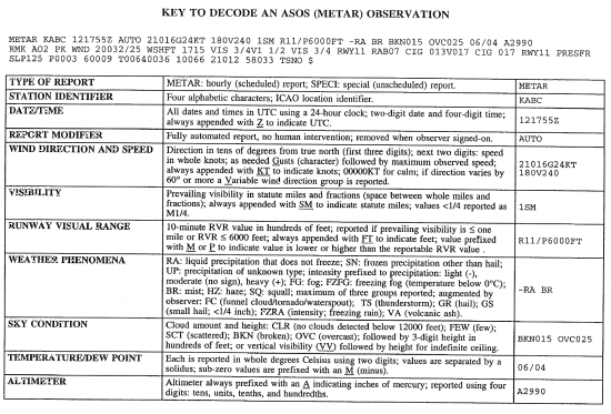
U.S.. (See Key to Decode an ASOS (METAR)
Observation: FIG 7-1-2
and FIG 7-1-3.) The
program to install and operate up to 993 systems
throughout the U.S. is a joint effort of the NWS,
the FAA and the Department of Defense. ASOS is
designed to support aviation operations and
weather forecast activities. The ASOS will
provide continuous minute-by-minute observations
and perform the basic observing functions
necessary to generate an aviation routine
weather report (METAR) and other aviation
weather information. The information may be
transmitted over a discrete VHF radio frequency
or the voice portion of a local NAVAID. ASOS
transmissions on a discrete VHF radio frequency
are engineered to be receivable to a maximum of
25 NM from the ASOS site and a maximum altitude
of 10,000 feet AGL. At many locations, ASOS
signals may be received on the surface of the
airport, but local conditions may limit the
maximum reception distance and/or altitude.
While the automated system and the human may
differ in their methods of data collection and
interpretation, both produce an observation
quite similar in form and content. For the
"objective" elements such as pressure, ambient
temperature, dew point temperature, wind, and
precipitation accumulation, both the automated
system and the observer use a fixed location and
time-averaging technique. The quantitative
differences between the observer and the
automated observation of these elements are
negligible. For the "subjective" elements,
however, observers use a fixed time, spatial
averaging technique to describe the visual
elements (sky condition, visibility and present
weather), while the automated systems use a
fixed location, time averaging technique.
Although this is a fundamental change, the
manual and automated techniques yield remarkably
similar results within the limits of their
respective capabilities.
1. System
Description.
(a)
The ASOS at each airport location consists
of four main components:
(1)
Individual weather sensors.
(2)
Data collection package(s) (DCP).
(3)
The acquisition control unit.
(4)
Peripherals and displays.
(b)
The ASOS sensors perform the basic function
of data acquisition. They continuously
sample and measure the ambient environment,
derive raw sensor data and make them
available to the collocated DCP.
2. Every ASOS
will contain the following basic set of
sensors:
(a)
Cloud height indicator (one or possibly
three).
(b)
Visibility sensor (one or possibly three).
(c)
Precipitation identification sensor.
(d)
Freezing rain sensor (at select sites).
(e)
Pressure sensors (two sensors at small
airports; three sensors at large airports).
(f)
Ambient temperature/Dew point temperature
sensor.
(g)
Anemometer (wind direction and speed
sensor).
(h)
Rainfall accumulation sensor.
3. The ASOS data
outlets include:
(a)
Those necessary for on-site airport users.
(b)
National communications networks.
(c)
Computer-generated voice (available through
FAA radio broadcast to pilots, and dial-in
telephone line).
NOTE-
Wind direction broadcast over FAA radios is
in reference to magnetic north.
4.
An ASOS/AWOS
report without human intervention will contain
only that weather data capable of being
reported automatically. The modifier for this
METAR report is "AUTO." When an observer
augments or backs-up an ASOS/AWOS site, the
"AUTO" modifier disappears.
5.
There are two
types of automated stations, AO1 for automated
weather reporting stations without a
precipitation discriminator, and AO2 for
automated stations with a precipitation
discriminator. As appropriate, "AO1" and "AO2"
shall appear in remarks. (A precipitation
discriminator can determine the difference
between liquid and frozen/freezing
precipitation).
NOTE-
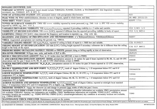
To decode an ASOS report, refer to FIG 7-1-2 and
FIG 7-1-3.
REFERENCE-
A complete explanation of METAR terminology is
located in AIM, Paragraph
7-1-28, Key to Aviation Routine Weather
Report (METAR) and Aerodrome Forecasts.
FIG 7-1-2
Key to Decode an
ASOS (METAR) Observation (Front)
FIG 7-1-3
Key to Decode an
ASOS (METAR) Observation (Back)
e.
TBL 7-1-1
contains a comparison of weather observing
programs and the elements reported.
f. Service
Standards.
During 1995, a
government/industry team worked to
comprehensively reassess the requirements for
surface observations at the nation's airports.
That work resulted in agreement on a set of
service standards, and the FAA and NWS ASOS
sites to which the standards would apply. The
term "Service Standards" refers to the level of
detail in weather observation. The service
standards consist of four different levels of
service (A, B, C, and D) as described
below. Specific observational elements included
in each service level are listed in
TBL 7-1-2.
1. Service Level
D
defines the minimum acceptable level of
service. It is a completely automated service
in which the ASOS observation will constitute
the entire observation, i.e., no additional
weather information is added by a human
observer. This service is referred to as a
stand alone D site.
2. Service Level
C is a
service in which the human observer, usually
an air traffic controller, augments or adds
information to the automated observation.
Service Level C also includes backup of ASOS
elements in the event of an ASOS malfunction
or an unrepresentative ASOS report. In backup,
the human observer inserts the correct or
missing value for the automated ASOS elements.
This service is provided by air traffic
controllers under the Limited Aviation Weather
Reporting Station (LAWRS) process, FSS and NWS
observers, and, at selected sites, Non-Federal
Observation Program observers.
Two categories of
airports require detail beyond Service Level C
in order to enhance air traffic control
efficiency and increase system capacity.
Services at these airports are typically
provided by contract weather observers, NWS
observers, and, at some locations, FSS
observers.
3. Service Level
B is a
service in which weather observations consist
of all elements provided under Service Level
C, plus augmentation of additional data beyond
the capability of the ASOS. This category of
airports includes smaller hubs or special
airports in other ways that have worse than
average bad weather operations for
thunderstorms and/or freezing/frozen
precipitation, and/or that are remote
airports.
4. Service Level
A, the
highest and most demanding category, includes
all the data reported in Service Standard B,
plus additional requirements as specified.
Service Level A covers major aviation hubs
and/or high volume traffic airports with
average or worse weather.
TBL 7-1-1
|
WEATHER
OBSERVING PROGRAMS |
|
Element
Reported |
AWOS-A
|
AWOS-1
|
AWOS-2
|
AWOS-3
|
ASOS
|
Manual
|
|
Altimeter
|
X |
X |
X |
X |
X |
X |
|
Wind
|
|
X |
X |
X |
X |
X |
|
Temperature/
Dew Point |
|
X |
X |
X |
X |
X |
|
Density
Altitude |
|
X |
X |
X |
X |
|
|
Visibility
|
|
|
X |
X |
X |
X |
|
Clouds/Ceiling
|
|
|
|
X |
X |
X |
|
Precipitation
|
|
|
|
|
X |
X |
|
Remarks
|
|
|
|
|
X |
X |
TBL 7-1-2
|
|
|
|
|
|
|
|
SERVICE
LEVEL A |
|
|
Service Level A
consists of all the elements of Service
Levels B, C and D plus the elements listed
to the right, if observed. |
10 minute
longline RVR at precedented sites or
additional visibility increments of 1/8,
1/16 and 0
Sector visibility
Variable sky condition
Cloud layers above 12,000 feet and cloud
types
Widespread dust, sand and other obscurations
Volcanic eruptions |
|
|
SERVICE
LEVEL B |
|
|
Service Level B
consists of all the elements of Service
Levels C and D plus the elements listed to
the right, if observed. |
Longline RVR at
precedented sites
(may be instantaneous readout)
Freezing drizzle versus freezing rain
Ice pellets
Snow depth & snow increasing rapidly remarks
Thunderstorm and lightning location remarks
Observed significant weather not at the
station remarks |
|
|
SERVICE
LEVEL C |
|
|
Service Level C
consists of all the elements of Service
Level D plus augmentation and backup by a
human observer or an air traffic control
specialist on location nearby. Backup
consists of inserting the correct value if
the system malfunctions or is
unrepresentative. Augmentation consists of
adding the elements listed to the right, if
observed. During hours that the observing
facility is closed, the site reverts to
Service Level D. |
Thunderstorms
Tornadoes
Hail
Virga
Volcanic ash
Tower visibility
Operationally significant remarks as deemed
appropriate by the observer |
|
SERVICE
LEVEL D |
|
This level of
service consists of an ASOS continually
measuring the atmosphere at a point near the
runway. The ASOS senses and measures the
weather parameters listed to the right.
|
Wind
Visibility
Precipitation/Obstruction to vision
Cloud height
Sky cover
Temperature
Dew point
Altimeter |
7-1-12.
Weather Radar Services
a.
The National
Weather Service operates a network of radar
sites for detecting coverage, intensity, and
movement of precipitation. The network is
supplemented by FAA and DOD radar sites in the
western sections of the country. Local warning
radar sites augment the network by operating on
an as needed basis to support warning and
forecast programs.
b.
Scheduled radar
observations are taken hourly and transmitted in
alpha-numeric format on weather
telecommunications circuits for flight planning
purposes. Under certain conditions, special
radar reports are issued in addition to the
hourly transmittals. Data contained in the
reports are also collected by the National
Center for Environmental Prediction and used to
prepare national radar summary charts for
dissemination on facsimile circuits.
c.
A clear radar
display (no echoes) does not mean that there is
no significant weather within the coverage of
the radar site. Clouds and fog are not detected
by the radar. However, when echoes are present,
turbulence can be implied by the intensity of
the precipitation, and icing is implied by the
presence of the precipitation at temperatures at
or below zero degrees Celsius. Used in
conjunction with other weather products, radar
provides invaluable information for weather
avoidance and flight planning.
d.
All En Route Flight
Advisory Service facilities and AFSS's have
equipment to directly access the radar displays
from the individual weather radar sites.
Specialists at these locations are trained to
interpret the display for pilot briefing and
inflight advisory services. The Center Weather
Service Units located in ARTCC's also have
access to weather radar displays and provide
support to all air traffic facilities within
their center's area.
e.
Additional
information on weather radar products and
services can be found in AC 00-45, Aviation
Weather Services.
REFERENCE-
Pilot/Controller Glossary, Radar Weather
Echo Intensity Levels.
AIM, Thunderstorms, Paragraph
7-1-26.
A/FD, Charts, NWS Upper Air Observing Stations
and Weather Network for the location of specific
radar sites.
7-1-13.
ATC Inflight Weather Avoidance Assistance
a. ATC Radar
Weather Display.
1.
Areas of radar
weather clutter result from rain or moisture.
Radars cannot detect turbulence. The
determination of the intensity of the weather
displayed is based on its precipitation
density. Generally, the turbulence associated
with a very heavy rate of rainfall will
normally be more severe than any associated
with a very light rainfall rate.
2.
ARTCC's use
Narrowband Radar which provides the controller
with two distinct levels of weather intensity
by assigning radar display symbols for
specific precipitation densities measured by
the narrowband system.
b. Weather
Avoidance Assistance.
1.
To the extent
possible, controllers will issue pertinent
information on weather or chaff areas and
assist pilots in avoiding such areas when
requested. Pilots should respond to a weather
advisory by either acknowledging the advisory
or by acknowledging the advisory and
requesting an alternative course of action as
follows:
(a)
Request to deviate off course by stating the
number of miles and the direction of the
requested deviation. In this case, when the
requested deviation is approved, navigation
is at the pilot's prerogative, but must
maintain the altitude assigned by ATC and to
remain within the specified mileage of the
original course.
(b)
Request a new route to avoid the affected
area.
(c)
Request a change of altitude.
(d)
Request radar vectors around the affected
areas.
2.
For obvious
reasons of safety, an IFR pilot must not
deviate from the course or altitude or flight
level without a proper ATC clearance. When
weather conditions encountered are so severe
that an immediate deviation is determined to
be necessary and time will not permit approval
by ATC, the pilot's emergency authority may be
exercised.
3.
When the pilot
requests clearance for a route deviation or
for an ATC radar vector, the controller must
evaluate the air traffic picture in the
affected area, and coordinate with other
controllers (if ATC jurisdictional boundaries
may be crossed) before replying to the
request.
4.
It should be
remembered that the controller's primary
function is to provide safe separation between
aircraft. Any additional service, such as
weather avoidance assistance, can only be
provided to the extent that it does not
derogate the primary function. It's also worth
noting that the separation workload is
generally greater than normal when weather
disrupts the usual flow of traffic. ATC radar
limitations and frequency congestion may also
be a factor in limiting the controller's
capability to provide additional service.
5.
It is very
important, therefore, that the request for
deviation or radar vector be forwarded to ATC
as far in advance as possible. Delay in
submitting it may delay or even preclude ATC
approval or require that additional
restrictions be placed on the clearance.
Insofar as possible the following information
should be furnished to ATC when requesting
clearance to detour around weather activity:
(a)
Proposed point where detour will commence.
(b)
Proposed route and extent of detour
(direction and distance).
(c)
Point where original route will be resumed.
(d)
Flight conditions (IFR or VFR).
(e)
Any further deviation that may become
necessary as the flight progresses.
(f)
Advise if the aircraft is equipped with
functioning airborne radar.
6.
To a large
degree, the assistance that might be rendered
by ATC will depend upon the weather
information available to controllers. Due to
the extremely transitory nature of severe
weather situations, the controller's weather
information may be of only limited value if
based on weather observed on radar only.
Frequent updates by pilots giving specific
information as to the area affected,
altitudes, intensity and nature of the severe
weather can be of considerable value. Such
reports are relayed by radio or phone to other
pilots and controllers and also receive
widespread teletypewriter dissemination.
7.
Obtaining IFR
clearance or an ATC radar vector to
circumnavigate severe weather can often be
accommodated more readily in the en route
areas away from terminals because there is
usually less congestion and, therefore, offer
greater freedom of action. In terminal areas,
the problem is more acute because of traffic
density, ATC coordination requirements,
complex departure and arrival routes, adjacent
airports, etc. As a consequence, controllers
are less likely to be able to accommodate all
requests for weather detours in a terminal
area or be in a position to volunteer such
routing to the pilot. Nevertheless, pilots
should not hesitate to advise controllers of
any observed severe weather and should
specifically advise controllers if they desire
circumnavigation of observed weather.
c.
Procedures for Weather Deviations and Other
Contingencies in Oceanic Controlled Airspace.
1.
When the pilot
initiates communications with ATC, rapid
response may be obtained by stating "WEATHER
DEVIATION REQUIRED" to indicate priority is
desired on the frequency and for ATC response.
2.
The pilot still
retains the option of initiating the
communications using the urgency call
"PAN-PAN" 3 times to alert all listening
parties of a special handling condition which
will receive ATC priority for issuance of a
clearance or assistance.
3.
ATC will:
(a)
Approve the deviation.
(b)
Provide vertical separation and then approve
the deviation; or
(c)
If ATC is unable to establish vertical
separation, ATC shall advise the pilot that
standard separation cannot be applied;
provide essential traffic information for
all affected aircraft, to the extent
practicable; and if possible, suggest a
course of action. ATC may suggest
that the pilot climb or descend to a
contingency altitude (1,000 feet above or
below that assigned if operating above FL
290; 500 feet above or below that assigned
if operating at or below FL 290).
PHRASEOLOGY-
STANDARD SEPARATION NOT AVAILABLE, DEVIATE
AT PILOT'S DISCRETION; SUGGEST CLIMB (or
descent) TO (appropriate altitude); TRAFFIC
(position and altitude); REPORT DEVIATION
COMPLETE.
4.
The pilot will
follow the ATC advisory altitude when
approximately 10 NM from track as well as
execute the procedures detailed in paragraph
7-1-13c5.
5.
If
contact cannot be established or revised ATC
clearance or advisory is not available and
deviation from track is required, the pilot
shall take the following actions:
(a)
If possible, deviate away from an organized
track or route system.
(b)
Broadcast aircraft position and intentions
on the frequency in use, as well as on
frequency 121.5 MHz at suitable intervals
stating: flight identification (operator
call sign), flight level, track code or ATS
route designator, and extent of deviation
expected.
(c)
Watch for conflicting traffic both visually
and by reference to TCAS (if equipped).
(d)
Turn on aircraft exterior lights.
(e)
Deviations of less than 10 NM or operations
within COMPOSITE (NOPAC and CEPAC) Airspace,
should REMAIN at ASSIGNED altitude.
Otherwise, when the aircraft is
approximately 10 NM from track, initiate an
altitude change based on the following
criteria:
TBL 7-1-3
|
Route
Centerline/Track |
Deviations >10 NM |
Altitude
Change |
|
EAST
000 - 179°M |
LEFT
RIGHT |
DESCEND 500
FEET
CLIMB 500 FEET |
|
WEST
180-359°M |
LEFT
RIGHT |
CLIMB 500
FEET
DESCEND 500 FEET |
|
Pilot
Memory Slogan: "East right up, West
right down." |
(f)
When returning to track, be at assigned
flight level when the aircraft is within
approximately 10 NM of centerline.
(g)
If contact was not established prior to
deviating, continue to attempt to contact
ATC to obtain a clearance. If contact was
established, continue to keep ATC advised of
intentions and obtain essential traffic
information.
7-1-14.
Runway Visual Range (RVR)
There are currently two configurations of RVR in
the NAS commonly identified as Taskers and New
Generation RVR. The Taskers are the existing
configuration which uses transmissometer
technology. The New Generation RVR's were deployed
in November 1994 and use forward scatter
technology. The New Generation RVR's are currently
being deployed in the NAS to replace the existing
Taskers.
a.
RVR values are
measured by transmissometers mounted on 14-foot
towers along the runway. A full RVR system
consists of:
1.
Transmissometer
projector and related items.
2.
Transmissometer
receiver (detector) and related items.
3.
Analogue
recorder.
4.
Signal data
converter and related items.
5.
Remote digital or
remote display programmer.
b.
The transmissometer
projector and receiver are mounted on towers 250
feet apart. A known intensity of light is
emitted from the projector and is measured by
the receiver. Any obscuring matter such as rain,
snow, dust, fog, haze or smoke reduces the light
intensity arriving at the receiver. The
resultant intensity measurement is then
converted to an RVR value by the signal data
converter. These values are displayed by readout
equipment in the associated air traffic facility
and updated approximately once every minute for
controller issuance to pilots.
c.
The signal data
converter receives information on the high
intensity runway edge light setting in use (step
3, 4, or 5); transmission values from the
transmissometer and the sensing of day or night
conditions. From the three data sources, the
system will compute appropriate RVR values.
d.
An RVR
transmissometer established on a 250 foot
baseline provides digital readouts to a minimum
of 600 feet, which are displayed in 200 foot
increments to 3,000 feet and in 500 foot
increments from 3,000 feet to a maximum value of
6,000 feet.
e.
RVR values for
Category IIIa operations extend down to 700 feet
RVR; however, only 600 and 800 feet are
reportable RVR increments. The 800 RVR
reportable value covers a range of 701 feet to
900 feet and is therefore a valid minimum
indication of Category IIIa operations.
f.
Approach categories
with the corresponding minimum RVR values. (See
TBL 7-1-4.)
TBL 7-1-4
Approach Category/Minimum RVR Table
|
Category
|
Visibility (RVR)
|
|
Nonprecision
|
2,400 feet
|
|
Category I
|
1,800 feet
|
|
Category II
|
1,200 feet
|
|
Category IIIa
|
700 feet
|
|
Category IIIb
|
150 feet
|
|
Category IIIc
|
0 feet
|
g.
Ten minute maximum
and minimum RVR values for the designated RVR
runway are reported in the body of the aviation
weather report when the prevailing visibility is
less than one mile and/or the RVR is 6,000 feet
or less. ATCT's report RVR when the prevailing
visibility is 1 mile or less and/or the RVR is
6,000 feet or less.
h.
Details on the
requirements for the operational use of RVR are
contained in FAA AC 97-1, "Runway Visual Range (RVR)."
Pilots are responsible for compliance with
minimums prescribed for their class of
operations in the appropriate CFR's and/or
operations specifications.
i.
RVR values are also
measured by forward scatter meters mounted on
14-foot frangible fiberglass poles. A full RVR
system consists of:
1.
Forward scatter
meter with a transmitter, receiver and
associated items.
2.
A runway light
intensity monitor (RLIM).
3.
An ambient light
sensor (ALS).
4.
A data processor
unit (DPU).
5.
Controller
display (CD).
j.
The forward scatter
meter is mounted on a 14-foot frangible pole.
Infrared light is emitted from the transmitter
and received by the receiver. Any obscuring
matter such as rain, snow, dust, fog, haze or
smoke increases the amount of scattered light
reaching the receiver. The resulting measurement
along with inputs from the runway light
intensity monitor and the ambient light sensor
are forwarded to the DPU which calculates the
proper RVR value. The RVR values are displayed
locally and remotely on controller displays.
k.
The runway light
intensity monitors both the runway edge and
centerline light step settings (steps 1 through
5). Centerline light step settings are used for
CAT IIIb operations. Edge Light step settings
are used for CAT I, II, and IIIa operations.
l.
New Generation
RVR's can measure and display RVR values down to
the lowest limits of Category IIIb operations
(150 feet RVR). RVR values are displayed in 100
feet increments and are reported as follows:
1.
100-feet
increments for products below 800 feet.
2.
200-feet
increments for products between 800 feet and
3,000 feet.
3.
500-feet
increments for products between 3,000 feet and
6,500 feet.
4.
25-meter
increments for products below 150 meters.
5.
50-meter
increments for products between 150 meters and
800 meters.
6.
100-meter
increments for products between 800 meters and
1,200 meters.
7.
200-meter
increments for products between 1,200 meters
and 2,000 meters.
7-1-15.
Reporting of Cloud Heights
a.
Ceiling, by
definition in the CFR's and as used in aviation
weather reports and forecasts, is the height
above ground (or water) level of the lowest
layer of clouds or obscuring phenomenon that is
reported as "broken," "overcast," or
"obscuration," e.g., an aerodrome forecast (TAF)
which reads "BKN030" refers to height above
ground level. An area forecast which reads
"BKN030" indicates that the height is above mean
sea level.
REFERENCE-
AIM, Key to Routine Weather Report (METAR) and
Aerodrome Forecasts (TAF), Paragraph 7-1-28, defines "broken,"
"overcast," and "obscuration."
b.
Pilots usually
report height values above MSL, since they
determine heights by the altimeter. This is
taken in account when disseminating and
otherwise applying information received from
pilots. ("Ceiling" heights are always above
ground level.) In reports disseminated as
PIREP's, height references are given the same as
received from pilots, that is, above MSL.
c.
In area forecasts
or inflight advisories, ceilings are denoted by
the contraction "CIG" when used with sky cover
symbols as in "LWRG TO CIG OVC005," or the
contraction "AGL" after, the forecast cloud
height value. When the cloud base is given in
height above MSL, it is so indicated by the
contraction "MSL" or "ASL" following the height
value. The heights of clouds tops, freezing
level, icing, and turbulence are always given in
heights above ASL or MSL.
|